Dictation questions. Dictation questions All-Russian geographical dictation November 20 questions
"All-Russian geographical dictation"Name the northernmost continental point of Russia.
What is the largest subject of the Russian Federation in terms of area, in which the easternmost of the peoples of the Turkic language group lives?
Name the city located in the Pacific Ocean, where the Sukhoi Superjet 100 passenger aircraft is manufactured.
Name the subject of the Russian Federation in which the construction of the easternmost cosmodrome of Russia is underway.
Name the city of the Russian Federation, in which, not far from the obelisk "Center of Asia", at the confluence of Biy-Khem and Ka-Khem, the Yenisei begins.
Name the largest of the Siberian cities located beyond the Arctic Circle, it is the center of mining and smelting of copper and nickel.
Name the rocks - a UNESCO natural heritage site, located along the Lena River.
Name the highest volcano in Russia.
Name the only river flowing from Lake Baikal.
Arrange the basins of Russian rivers in sequence corresponding to the direction from west to east: A) Khatanga; B) Indigirka; B) Onega; D) Nadym.
Select from the list a city located in the drainage basin of the Kara Sea: A) Yakutsk; B) Irkutsk; D) Naryan-Mar; D) Magadan.
Arrange the subjects of the Russian Federation in sequence from north to south: A) the Republic of Kalmykia; B) Republic of Ingushetia; C) the Republic of Mari El; D) Republic of Karelia.
Name the mountain system within which the wettest (according to the average annual precipitation) territory in Russia is located.
What is the date and time on the clock of a tourist climbing to the top of Elbrus, when on the clock of his friend, who is resting on the shores of Peter the Great Bay, 5 am on May 1?
“In Kandalaksha, dazzling mountains covered the horizon with snow domes. At the roadbed, the Niva River with black clear water roared like a continuous waterfall. Then Lake Imandra passed - not a lake, but a sea - all in blue ice, surrounded by steps of blue and white mountains. Khibiny slowly went to the south with smoothed domes. What peninsula did K.G. Paustovsky?
About this current city-millionaire D.N. Mamin-Sibiryak wrote: “In the motley environment of Russian cities ... it is really a “living knot” ... At the pass itself, two large rivers almost meet - Iset and Chusovaya. It was at this point that Tatishchev outlined the future city ... The Iset River ... connected the mining region itself with the blessed [land] - a golden bottom, where forests, pastures and steppe Siberian black soil were widely scattered.
“Conversations and descriptions of Vaigach, which the Dutch call Nassav Strait, hearing in Holland, many nobles zealously undertook to send another large parcel in order to pass to China and India ... Barens was appointed leader on the largest of the two ships that were sent from Amsterdam. ..". What geographical object bears the name of the mentioned M.V. Lomonosov of the Dutch navigator?
“... Our guys ... were flying at that moment on a small An-2 plane north of the New Siberian Islands, where there are points of the De Long Islands: Jeannette Island, Henrietta Island, and Zhokhov Island are also there ... "(O. M. Kuvaev). In which sea are the De Long Islands located?
“... This is a virgin and primeval forest, consisting of cedar, black birch, Amur fir, elm, poplar, Siberian spruce, Manchurian linden, Dahurian larch, ash, Mongolian oak ... cork tree ... And all this was mixed up by a vineyard , creepers and sultanas. What kind of Russian forest is V.K. Arseniev?
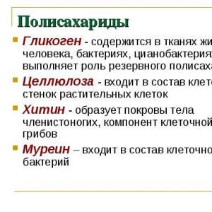
Name a phenomenon of a global scale, which is spread over 60% of the territory of Russia. It is most widely represented in Eastern Siberia and Transbaikalia. The greatest depth of distribution of this phenomenon (1370 m) is noted in the upper reaches of the Vilyui River in Yakutia.
What is the name of the hot springs that periodically throw out fountains of hot water and steam, which are common in areas of volcanic activity, for example, on the Kamchatka Peninsula?
What is the indicator that characterizes the number of inhabitants per 1 km 2 of territory and determines the demographic and economic potential of a country or region.
What is the process of urban growth and an increase in the proportion of the urban population called?
On a map at a scale of 1:10,000, the distance between points is 10 cm. What distance on the ground does this correspond to?
Name the oldest and deepest lake in the world, which contains 20% of all fresh water on the planet.
Answers:
1. Permafrost. 2. Geysers. 3. Population density; 4. urbanization; 5. 1 km; 6. Lake Baikal; 7. Cape Chelyuskin on Taimyr; 8. Republic of Sakha-Yakutia;9. Komsomolsk-on-Amur; 10. Amur region; 11. the city of Kyzyl - the capital of the Republic of Tuva; 12. city of Norilsk; 13. Lena Pillars; 14. Klyuchevskoy volcano as part of Klyuchevskaya Sopka - 4850 m; 15. Angara river; 16. Onega-Nadym-Khatanga-Indigirka;17. Irkutsk; 18. Karelia-Mariy-El-Kalmykia-Ingushetia;19. northwestern Caucasus; 20. 22:00 April 30; 21. Kola Peninsula; 22. Yekaterinburg, 23. Barents Sea; 24. East-Siberian Sea; 25. Far Eastern Ussuri taiga
On November 20, the All-Russian geographical dictation was held throughout the country. In Orenburg, one of the venues for it was the Orenburg State University. The conference hall of the scientific library of OSU on the 7th floor was almost full by the beginning of the dictation. There were students, schoolchildren, geography teachers who also tested their knowledge, and other people interested in geography. My favorite subject at school was geography, I had several atlases and I liked to study and look at them, so it was interesting to test my knowledge.
Before the start of the dictation, representatives of the university and the guest of honor Alexander Alexandrovich Chibilev, Russian geographer, academician of the Russian Academy of Sciences, doctor of geographical sciences, professor, delivered a welcoming speech.
As a warm-up, docents of the university held a small quiz of questions similar to those that will be in the dictation. Those who answered correctly received atlases and books about the reserves of the Orenburg region from Alexander Alexandrovich Chibilev as a gift.

Then there was a short briefing on how to fill out the participant's questionnaire. The dictation is conducted anonymously, you do not need to indicate your last name and first name, only general information: gender, age, education, field of activity for compiling statistics.
The dictation consists of 30 questions, which could be conditionally divided into three sections, questions on the knowledge of geographical terms and names, questions about the location of geographical objects and questions where it was necessary to guess a geographical object from excerpts from works of art.
The time for writing the dictation is 45 minutes. A video was launched through the projector, where questions were read out and there was a timer for each question, the time for the answer was different depending on the complexity. Each question was accompanied by a picture, which in most cases was also a good clue.
In general, the questions are not very difficult, more than half should definitely be correct. But some I already know that I answered incorrectly (
I did not like that some of the people sitting next to each other conferred and voiced their supposed answers. Still, this is a test of their knowledge, and not a collective answer.
They said that the results will be known at the end of December, we will wait!
Those who did not go to the dictation in person can take the online dictation. It will last until November 23 inclusive and end at 14:00 Moscow time. Here you can see the results immediately. This is another option with questions similar to those that were in the face-to-face dictation. I have already passed the online dictation and scored 71 points out of a hundred. Now I will wait for the results of the full-time dictation, for some reason it seems to me that the results here should be better.

Copied questions. I want to show my geography teacher tomorrow. It is a pity that only one option has been prepared for the online dictation ... I tried again: 65 b. I'll google the answers later, at my leisure. Below I give the answers that helped me score my 49 b.
Delete
1. What is the name of an imaginary line on the surface of the globe that connects the North and South Poles at the shortest distance?
2. What is the name of the interface between warm and cold air masses in the lower part of the atmosphere?
3. What is the name of a city located near a larger city and gravitating towards it in economic and cultural terms?
She gave wrong answers to the first three questions.
4. What is the name of the part of the river valley that is flooded during floods or during floods? Answer: floodplain.
5. Indicate the combination of natural zones and soils characteristic of the territory of the Central Federal District (it is enough to indicate the letter):
A) forest-steppe - red soils;
B) northern taiga - brown soils;
C) mixed forests - soddy-podzolic soils.
Answer: V
6. Select from the list the object with the lowest salinity of water (it is enough to indicate the letter):
A) Sivash Bay;
B) the White Sea;
B) the Gulf of Finland;
D) the Black Sea.
7. What does this symbol mean on topographic maps?
Answer: shrubs.
8. Arrange the mountain systems in descending order of their maximum absolute height (fill in the numbers):
1) Altai; 2) Caucasus; 3) Sikhote-Alin; 4) Khibiny.
9. The name of this people of Russia is translated as “real person”, and the outdated name is Samoyeds. The number in Russia is about 45 thousand people, most of them live along the coast of the Arctic Ocean from the Kola Peninsula to Taimyr. The main occupations are reindeer herding, fishing, and hunting. The name of the people is present in the names of two subjects of the Russian Federation. Name the people.
Answer: Eskimos
10. This folk craft bears the name of a village in the Moscow region, where it originated at the beginning of the 19th century. Traditional handicrafts are metal trays painted with oil paints, usually with a pattern of a flower bouquet. Name the industry.
Answer: Zhostovo.
11. What is the name of solid atmospheric precipitation that forms on the surface of the earth and plants at negative soil temperatures, cloudy skies and light winds?
Answer: frost. (Perhaps frost, I don’t argue.)
12. Name the natural zone of Russia where oak and hazel grow, oriole and wild boar live.
Answer: forests.
13. Arrange the settlements in the direction from north to south (put in the letters):
A) Vologda; B) Salekhard; B) Khabarovsk; Novosibirsk city.
14. Name the archipelago, which is the northernmost island territory of Russia.
15. Select from the list a city where the sun can sometimes be seen at midnight (just specify the letter):
A) Syktyvkar; B) Murmansk; B) Omsk; D) Tomsk.
Answer: B.Continuation.
16. The Novgorod Kremlin and the Church of Peter and Paul on Sinichya Gora are included in the list of UNESCO World Heritage Sites. The distance between them in a straight line is 1.5 kilometers. What will it be equal to on a map at a scale of 1:50,000? Give your answer in centimeters.
Confused by the numbers...
17. Select from the list the subject of the Russian Federation, a significant part of which is located in the subarctic climate (it is enough to indicate the letter):
A) the Republic of Karelia;
B) the Republic of Tatarstan;
C) Tyumen region;
D) Perm region.
Answer: A.
18. Name the tributary of the Ob River, which crosses two state borders before entering the territory of Russia.
19. Indicate in which city from the list sunrise occurs earlier than others (it is enough to indicate the letter):
A) Yakutsk;
B) Okhotsk;
B) Khanty-Mansiysk;
D) Veliky Ustyug.
20. Name the subject of the Russian Federation in which the time differs from Kamchatka by 10 hours.
Answer: Kaliningrad.
21. Select from the list the river, the lower reaches of which are shown on the satellite image (it is enough to indicate the letter):
A) Volga;
B) Lena;
B) Selenga;
D) Yenisei.
I think the hardest question...
22. Name the Hero City of Russia, one of the largest ports of the Black Sea, located on the shores of the Tsemesskaya Bay.
23. Name the sea washing the coast of Russia, which is characterized by the highest tides. The sea is rich in fish, seafood and hydrocarbons. Previously, it was called Kamchatka. In its southern part there are the Odessa Bay and the Gulf of Patience.
Answer: Sea of Okhotsk.
24.Select a pair of objects from the list that are not geographically related to each other (just specify a letter):
A) Lake Taimyr - the Taimyr Peninsula;
B) Bering Island - Bering Sea;
C) Bely Island - White Sea;
D) the Kamchatka River - the Kamchatka Peninsula.
Answer: B. (I've never heard of Bely Island, so I chose B).
25. Name the city, the ancient capital of North-Eastern Russia, at present - the regional center on the Klyazma River, which is part of the Golden Ring of Russia tourist route.
26. What natural area does Vasily Dokuchaev write about:
“... it seems to be so densely occupied by some kind of plant that nothing else, apparently, can fit here: either it is covered with purple spots - these are anemones in bloom, then whole meadows take on a blue azure color - these are forget-me-nots; at other times you can find large areas completely covered with fragrant thyme ... ".
Answer: steppe.
27. Find out the city described in the poem by Alexander the North:
This city in five centuries
Standing on the edge of the coast
The border of snow, eternal ice,
The capital of rivers, forests, swamps.
Standing on a centuries-old path
Nobody can get around.
All ships met here
That from the White Sea they went to people.
Met Norwegians and Slavs,
Met the Dutch, the British
The Varangians went to the last battle
And the Swedes are beaten astern.
By the age-old by this river
The Pomors built the city...
Answer: Arkhangelsk
28. “The great strategist moved at a shooting pace along the mountain road leading around Mashuk to the place of the duel between Lermontov and Martynov, past sanatoriums and rest houses. Overtaken by buses and two-horse carriages, Ostap went to Proval (Ilya Ilf and Evgeny Petrov). The landmark of which city is considered to be the failure mentioned in the excerpt?
Answer: Pyatigorsk
29. Name the territory described in the story of Konstantin Paustovsky:
“This region lies ... between Vladimir and Ryazan, not far from Moscow, and is one of the few surviving forest islands, the remnant of the “great belt of coniferous forests.” In ... the region you can see forest lakes with dark water, vast swamps covered with alder and aspen.
Answer: Meshchera.
30. Name the expedition that took place in 1937-1938, in which Ivan Papanin, Evgeny Fedorov, Ernst Krenkel and Pyotr Shirshov, depicted on a postage stamp, became famous.
Answer: North Pole. (I confess, I didn’t know about such an expedition. My intuition didn’t let me down: I looked at the postage stamp in the assignment and decided that, perhaps, the North Pole. It turns out that I was right. Then I read about the expedition on the Internet. The expedition members are real heroes!)
Hello, Natalya Borisovna!
49 points is also not bad! Maybe try another version? Again? Just for myself to remember... Or better yet, open an online dictation, google the answers, write them down in a notebook and learn the answers! That's definitely useful!
And literary questions were hard for me - I need to work on myself))))
To use the preview of presentations, create a Google account (account) and sign in: https://accounts.google.com
Slides captions:
Question 1 Name a global phenomenon that is spread over 60% of the territory of Russia. It is most widely represented in Eastern Siberia and Transbaikalia. The greatest depth of distribution of this phenomenon (1370 m) is noted in the upper reaches of the Vilyui River in Yakutia.
Question 2 What are the names of hot springs that periodically throw out fountains of hot water and steam, which are common in areas of volcanic activity, for example, on the Kamchatka Peninsula?
Question 3 What is the indicator that characterizes the number of inhabitants per 1 km 2 of territory and determines the demographic and economic potential of a country or region.
Question 4 What is the name of the process of urban growth and increase in the proportion of the urban population?
Question 5 On a map at a scale of 1:10,000, the distance between points is 10 cm. What distance (in kilometers) on the ground does this correspond to?
Question 6 Name the oldest and deepest lake in the world, which contains 20% of all fresh water on the planet.
Question 7 What is the northernmost continental point of Russia.
Question 8 What is the largest subject of the Russian Federation in terms of area, in which the easternmost of the peoples of the Turkic language group lives?
Question 9 Name the city located in the Pacific Ocean where the Sukhoi Superjet 100 passenger aircraft is manufactured.
Question 10 What is the subject of the Russian Federation, in which the construction of the easternmost cosmodrome of Russia is underway.
Question 11 Name the peninsula located to the west of the Gulf of Ob, the subsoil of which contains the richest reserves of natural gas.
Question 12 The largest seaport in southern Russia, located in this hero city, often suffers from strong cold winds that rapidly “fall” from the mountains. Name this city.
Question 13 Name the UNESCO natural heritage island that the 180th meridian passes through. This island is also called the "polar bear nursery".
Question 14 What is the highest point of the Altai Mountains.
Question 15 Name the city where the Trans-Siberian Railway crosses the Ob River.
Question 16 Arrange the mouths of Russian rivers in sequence corresponding to the direction from east to west: A) Pechora; B) Taz; B) Kolyma; D) Angara. Enter the letters in the correct order in the text field.
Question 17 Select from the list a city that is located in the drainage basin of the Caspian Sea: Voronezh Krasnodar Tver Kursk Smolensk
Question 18 Arrange the subjects of the Russian Federation in order from east to west: A) the Chechen Republic; B) Kaliningrad region; C) Perm region; D) Chukotka Autonomous Okrug.
Question 19 What is the name of the sea or lake that washes the wettest (according to the average annual precipitation) territory of Russia.
Question 20 What is the date and time on the watch of a tourist climbing to the top of Klyuchevskaya Sopka, when on the clock of his friend, resting on the Curonian Spit, 20:00 on June 12?
Question 21 “For the first time I saw from the distance of the sea… the entire solemn turn of its shores from Cape Fiolent to Karadag. For the first time I realized how beautiful this land is, washed by one of the most festive seas on the globe. We are approaching the shores, colored with dry and sharp colors ... The vineyards were already aflame with rust, the snow-covered peaks of Chatyr-Dag and Ai-Petri were already visible. What peninsula did K.G. Paustovsky?
Question 22 In what city did M.Yu. Lermontov? “The view from three sides is wonderful. To the west, the five-domed Beshtau turns blue, like “the last cloud of a scattered storm”; Mashuk rises to the north, like a shaggy Persian hat, and covers the entire part of the sky; it’s more fun to look to the east: below in front of me ... healing springs rustle, a multilingual crowd rustles, - and there, further, the mountains are piled up like an amphitheater, bluer and foggier, and on the edge of the horizon stretches a silver chain of snowy peaks, starting with Kazbek and ending with the two-headed Elborus ... ".
Question 23 “... In winter, the sea winds thaw, and from the mother earth they bring frosts with them, because in St. thaw breathe." Which sea M.V. Lomonosov calls Normansky?
Question 24 “Anadyr depression. It is very flat, and Anadyr wags a huge boa constrictor along it ... “Anadyr is a yellow river,” - you can call the essay like that later. Tundra and lakes throughout the depression. It is difficult to understand what is more: either lakes or land” (O.M. Kuvaev). What sea does this river flow into?
Question 25 “Great trees formed a green tent. And under it - dense thickets of hazel, bird cherry, honeysuckle, elderberry and other shrubs and small trees. In some places, a gloomy dark spruce forest has moved in. On the outskirts of the clearing, a large pine tree spread its branches, under the shade of which a young Christmas tree nestled ... And then again birches, poplar with its gray trunk, mountain ash, linden, the forest is getting thicker and darker. What kind of Russian forest is L.M. Leonov?
On November 20, 2016 at 12:00 local time, the All-Russian Geographical Dictation will take place in 85 constituent entities of the Russian Federation. The large-scale event organized by the Russian Geographical Society on the initiative of the Chairman of the Board of Trustees of the Russian Geographical Society, President of the Russian Federation Vladimir Putin, will be held in Russia for the second time. As in 2015, the text of the dictation was compiled in three versions for the regions of the Far East, Siberia and Central Russia. Questions will be devoted, first of all, to the geography of Russia. Among the main objectives of the educational action is an independent assessment of the geographical literacy of Russians, the motivation of citizens to study the geography of their country. Anyone can take part in the All-Russian Geographical Dictation educational campaign, regardless of age and education.
On November 20, 2016 at 14:00, an online dictation starts on the website dictant.rgo.ru. It will last from November 20-23 (until 14:00 Moscow time).
In the city of Muravlenko on the basis of MBOU "School No. 3 named after A.I. Pokryshkin” (YaNAO, Muravlenko, Shkolnaya st. 17, rooms 1,2,3,4) organized a platform for conducting a geographical dictation. Applications for participation in the Dictation are accepted by e-mail school [email protected] uomur. org, by phone 8(34938)44300. The application must contain the following information: 1. Full name of the participant 2. Gender 3. Occupation
Contact person Koltykova Irina Vladimirovna. Phone: 89088525391
e-mail: [email protected]
Schedule of the site in Muravlenko, MBOU "School No. 3 named after A.I. Pokryshkin":
11:00 - the beginning of the site, the gathering of participants in the All-Russian geographical dictation.
11:00 -12:00 - collection, registration of participants and issuance of forms for participants in the Dictation (at this time, popular science videos, TV shows, animated films, commercials are shown on the site);
12.00-12.15 - quiz, briefing on filling out forms for writing Dictation;
12.15-13.00 - writing a dictation.
13:00-13:30 collection of completed forms for writing Dictation;
13.30 - closing of the site.
We invite everyone to take part in the event!