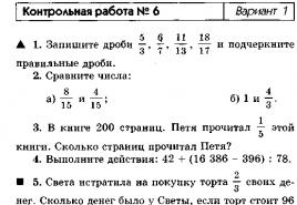
Verification work number 14 in geography. Verification and control works on geography
Date: ___________
Purpose: To identify the degree of assimilation of educational material for __________ academic. year.
2. Who is considered the "father of geography". He also outlined the idea of the sphericity of the Earth and quite accurately calculated the length of the equator and the radius of the Earth?
3.Write in your own words what UNESCO is.
4. What device can be used to determine the time from the Sun?
5. Which of the listed terrestrial planets are superfluous?
a) Mercury, Venus, Earth, Mars b) Mercury, Venus, Earth, Mars, Neptune) Mercury, Venus, Earth, Mars, Jupiter
6. For the first time you made the assumption that the Earth does not have the shape of an ideal ball?
a) Archimedes b) Aristotle c) Newton
7. Relate the days of the vernal and autumnal equinoxes and the days of the summer and winter solstices. Write your answer in pairs.
A) the day of the vernal equinox 1) December 22
B) the day of the summer solstice 2) September 23
B) the day of the autumnal equinox 3) March 21
D) the day of the winter solstice 4) June 22
a) match b) do not match
9. In what direction does the Earth rotate around its axis?
10. List the geographic consequences of the axial rotation of the Earth?
11. In which zones of illumination of the Earth are all four seasons observed?
12. List the internal structure of the Earth.
13. Where is the earth's crust thicker?
a) under the oceans b) under the continents
14. What causes earthquakes and volcanic eruptions?
15. Examples of sedimentary rocks are?
a) sand, gypsum, coal, pumice b) sand, gypsum, coal
16. Examples of metamorphic rocks can be?
a) slate, marble b) marble, basalt
17. On the earth's surface, right above the earthquake source, ____? _____ is located, which can cover an area of up to several tens of square kilometers.
18. If the source of an earthquake is under the ocean floor, then long waves are formed over the water surface. Such waves move very quickly, reaching the coast and falling on them with great force, bringing with them destruction. What are these waves called?
19. What is the name of the air shell of the earth?
a) hydrosphere b) atmosphere c) lithosphere
20. What layer of the atmosphere contains ozone?
a) stratosphere b) troposphere c) thermosphere d) mesosphere
21. What is the name of the state of the atmosphere at a given time and in a given area?
a) climate b) weather
22. What is the name of the device with which the wind direction is determined?
a) hygrometer b) weather vane c) rain gauge 23. What is the name of the device for determining the temperature and humidity of the air?
a) rain gauge b) hygrometer c) thermometer
24. What is the name of the part of the ocean, separated by land areas or underwater uplifts of the bottom, which differs from it in the properties of water, currents and living organisms?
a) bay b) strait c) sea d) ocean
25. Which of the following is not an ocean?
a) Barents b) North-Arctic c) Atlantic d) Indian e) Quiet
26. Is it true that the largest peninsula on Earth is the Arabian Peninsula, and the largest peninsula in Russia is Taimyr?
a) yes b) no
27. The place where the river originates is called?
a) mouth b) source
28. To the basin of which ocean do the rivers belong: Yenisei, Lena, Ob?
a) Quiet b) Atlantic c) Indian d) Arctic
KS in geography in grade 5
option
1. What science studies geographic objects, processes and phenomena in the geographic envelope of our planet?
a) geology b) geography c) biology
2. Who is considered the "father of geography". He also outlined the idea of the sphericity of the Earth and quite accurately calculated the length of the equator and the radius of the Earth?
a) Eratosthenes b) Herodotus c) Aristotle
3. Natural objects include: a) football field b) swimming pool c) swamp d) playground
a) level b) gnomon c) barometer
5. What method of geographical research was used in compiling this text? Tropical forests occupy a significant part of the world's forest area and are the main source of valuable timber. It is a huge storehouse of food, technical, medicinal and other useful plants.
6. Which of the listed terrestrial planets are superfluous?
a) Mercury, Venus, Earth, Mars b) Mercury, Venus, Earth, Mars, Neptune
c) Mercury, Venus, Earth, Mars, Jupiter
7. Select the geographic implications of the Earth's axial rotation?
a) there is a change of seasons b) there is a change of day and night
8. Do the dates of the onset of astronomical seasons and phenological phenomena in our area coincide?
a) match b) do not match
a) polar b) moderate c) equatorial
A) Solar system B) geographic pole
KS in geography in grade 5
"Introduction. Earth is a planet of the solar system "
Option 2
1. The word "geography" in translation from Greek means: a) agriculture b) land descriptions) geography
2.The first to determine the size of the globe a) Pythagoras b) Eratosthenes c) Aristotle) Ptolemy
3 Man-made objects include: a) a hill b) a pool c) a swamp d) an island
4 .. What device can be used to determine the time from the Sun?
a) gnomon b) barometer c) level
5. What geographical research methods can be used to confirm this information: Rainforests occupy large areas on both sides of the equator in America, Africa, in the southern and southeastern parts of Asia and the adjacent islands, in Australia. the famous victoria regia grows.
6.Specify, between the orbits of which planets is the orbit of the planet Earth?
1) between Saturn and Uranus 3) Between Mars and Venus
2) between Mercury and Venus 4) between Uranus and Pluto
7. Choose the geographic consequences of the Earth's motion in the circumsolar orbit?
a) there is a change of seasons b) there is a change of day and night
8. In what direction does the Earth rotate around its axis?
a) from west to east b) from east to west
9. In which zones of illumination of the Earth are all four seasons of the year observed?
a) equatorial b) polar c) moderate
10. Write a definition of the following concepts:
A) geography B) day length
KS in geography in grade 5
"Internal structure of the Earth"
Option 1
A.1 What is the lithosphere?
1.the earth's crust and the upper part of the mantle; 3.the air shell.
2. the water shell of the Earth; 4. the aquatic shell of the Earth.
A.2 What occupies most of the Earth's volume?
A.3.What layer is not distinguished in the continental crust?
1.granite; 2. sedimentary; 3.sandy; 4. basalt.
A.4 What method allows you to study the interior of the Earth?
1. drilling wells; 2.underground; 3.seismic; 4. space.
A.5 What rocks are not sedimentary?
1.clastic; 2. chemical; 3.organic; 4.magmatic.
A.6. What is superfluous from the point of view of the origin of the volcano?
1.harlo; 2. glory; 3.crater; 4.epicenter.
A.7. The formation of a tsunami is associated with ……………… ..
1.volcanoes; 2. earthquake; 3. slow fluctuations; .4.reelf
A.8.What is the name of the device with which you can fix the vibrations of the earth's crust.
1. jeweler; 2.echo sounder; 3.seismograph; 4.transportator.
A.9 What is the name of the hole at the top of the volcano?
Q.1 What is the name of the area of the earth's surface where tremors of the greatest strength are observed? ______________________________
The set of irregularities in the land surface is called …………………………
C.1 What determines the height of the volcano's cone?
C.2 Why do geysers form?
KS in geography in grade 5
"Internal structure of the Earth"
Option 2
A.1 Indicate the outer layer of the Earth.
1.The core; 2.mantle; 3.earth crust; 4.the outer core.
A.2. Please provide the correct statement.
1.The thickness of the earth's crust is the same everywhere.
2.The oceanic crust is thicker than the mainland.
3.The continental crust is thicker than the oceanic one.
A.3.What layer besides sedimentary does the oceanic crust contain?
1.granite; 2.peat; 3.sandy; 4. basalt.
A.4 Indicate the subgroup of rocks.
1.clastic; 2. sedimentary; 3.metamorphic; 4.magmatic.
A.53.Specify the rock of igneous origin.
1.granite; 2.marble; 3.sand; 4.quartzite.
A.6 Which part is related to the earthquake?
1.harlo; 2.magma; 3. focus; 4.crater.
A.7. The formation of geysers is associated with ………… ..
1.Earthquake; 2. a volcano; 3.relief; 4. plains.
A.8 What is the name of the place in the earth's crust where the displacement and rupture of rocks occurs?
1.epicenter; 2.magma; 3. hearth; 4. crater.
A.9. Along the shores of which ocean is the seismic belt of the Earth?
1.North Arctic; 2. Atlantic; 3. Quiet; 4.Indian.
B.1 Science that studies the origin of seismic waves in the bowels of the Earth
____________________________________________________________
B.2 Insert the missing word.
The excess of one point over another on the earth's surface is called ………………………………………….
C.1 What is the difference between lava and magma?
C.2 Why do the areas of distribution of geysers and volcanoes coincide?
KS in geography in grade 5
"Atmosphere"
Option 1
A1 What is the lower limit of the atmosphere?
A) the earth's surface B) the level of the World Ocean
C) upper boundary of the mantle D) upper boundary of the troposphere
A2.What gas is dominant in the atmosphere?
A) oxygen B) hydrogen C) nitrogen d) carbon dioxide.
A3.What layer of the atmosphere protects the Earth's surface from destructive action?
A) troposphere B) stratosphere C) thermosphere D) ozone
A4.What layer of the atmosphere is above the troposphere?
A) stratosphere B) mesosphere C) thermosphere D) exosphere
A5.What is the significance of the Earth's atmosphere?
D) all answers are correct
A6.What is not a weather element?
A) temperature B) pressure C) cloudiness D) annual precipitation
1.Atmospheric pressure A. hygrometer
2.Precipitation B. weathervane
3.Humidity V.barometer
4.wind force G. thermometer
5.Temperature E. Rain gauge B2. Insert the missing words.
When carbon dioxide enters the atmosphere, the heat emitted from the Earth is trapped in the atmosphere. This phenomenon is usually called ____________________________________________________
A) atmosphere B) mirages
KS in geography in grade 5
"Atmosphere"
Option 2
A1 What layer of the atmosphere is farthest from the Earth?
A) stratosphere B) troposphere C) mesosphere D) thermosphere
A2.What gas in the atmosphere provides combustion processes?
A) carbon dioxide B) nitrogen C) oxygen D) helium
A3 In what layer does the weather change?
A1 in the ozone B) in the troposphere C) in the mesosphere D) in the thermosphere
A4. How do scientists study the atmosphere?
A) meteorological stations B) meteorological rockets
C) artificial satellites D) all answers are correct A5. What is the significance of the Earth's atmosphere?
A) air is necessary for breathing B) meteoric bodies burn in it
C) it protects the Earth from strong heating and cooling
D) all answers are correct
A6.What is the state of the lower atmosphere at a given time and place called?
A) climate B) air C) weather D) air mass
B1. Set the correspondence between the weather element and the measuring device:
1.temperature A.hygrometer
2.Precipitation B. weathervane
3.wind strength V.barometer
4.Humidity H. Thermometer
5atmospheric pressure D. rain gauge
B2 Insert the missing words.
A person feels comfortable at a temperature of ___________________
And the relative humidity is within _____________________________
C1 Write a definition of the following concepts:
A) troposphere B) hail
Geography test
Topic: "Hydrosphere". Grade 5
Option 1.
Part 1.
1. By area of the Atlantic Ocean
A) second only to the Quiet;
B) surpasses the Pacific, Indian and Arctic;
C) surpasses the Arctic, but inferior to the Pacific and Indian.
D) second only to the Indian.
2. Fill in the blanks.
Salt waters of the hydrosphere account for _____%, and _____% are fresh waters.
3. Inland seas are
A) Black and Red; B) Arabian and North;
C) Greenlandic and Japanese; D) Kara and Baltic.
4. Among the listed lakes, the deepest is
A) Air North; B) Baikal; C) Victoria; D) Top.
5. The Bay of Bengal refers to the ocean:
A) Indian; B) Quiet;
C) Atlantic; D) Arctic.
6. Among the listed islands, the largest by area is the island
A) Sakhalin; B) Greenland; C) Tierra del Fuego; D) Sri Lanka.
7. Indicate three states of water in nature: 1 ……. 2 …… 3 …….
8. The longest river in the world
A) Amazon; B) Mississippi; C) Neil; D) Mekong.
9. Arrange the oceans in order of decreasing area: A) Indian; B) Quiet; C) Arctic; D) Atlantic.
10. Covering glaciation is widespread
A) in Greenland; B) in the Himalayas;
C) in the Pamirs; D) in the Cordilleras.
Part 2.
1. Establish the correspondence "sea - ocean to which it belongs"
A) Red; 1) Quiet;
B) Baltic; 2) Arctic;
B) Barents; 3) Indian;
D) Beringovo; 4) Atlantic.
2. Establish which natural object the sailors and passengers of the ship collided with.
Suddenly, the ice mountain sparkling in the sun began to quickly move away from the steamer, and at that moment the ship's hull experienced a sharp jolt. The amazed sailors and passengers saw that the steamer was lying on a huge ice floe and with every second it was rising higher and higher above the surface of the water _______________________________________________________________
3. What numbers indicate the following concepts?
A) Source
B) River basin
C) estuary
D) Watershed
E) Inflow
4. Which word should be removed from the list? Explain how the following concepts are combined?
river, stream, lake, glacier, ocean, key, swamp
5. What is a river?
Geography test
Topic: "Hydrosphere". Grade 5
Option 2.
Part 1.
1. In terms of average depth, the second after the Pacific Ocean is ... the ocean
A) Atlantic; B) Arctic; C) Indian.
2. Fill in the blanks.
3. The marginal sea is
A) Red; B) Black;
C) Beringovo; D) Mediterranean.
4. The saltiest lake in the World Ocean is
A) Dead; B) Baikal;
C) Caspian; D) Air North.
5. The Strait of Gibraltar connects
A) North and Baltic seas;
B) the Pacific and Arctic Ocean;
C) Red Sea and Indian Ocean;
D) Mediterranean Sea and Atlantic Ocean.
6. The largest island in the Land of Greenland is located off the coast of the mainland
A) Eurasia; B) North America;
C) Africa; D) South America.
7. Indicate three properties of water that it does not have: 1 ……. 2 …… 3 …….
8. The highest waterfall in the world:
A) Victoria; B) Niagara; C) Angel; D) Khon.
9. Among the rivers listed, the largest river system is formed by the river
A) Volga; B) Amazon; C) Ganges; D) Neil.
10. Arrange the oceans in order of increasing area: A) Indian; B) Quiet; C) Northern Arctic; D) Atlantic.
Part 2.
1. Set the correspondence "bay - ocean to which it belongs"
A) Guinean; 1) Quiet;
B) Mexican; 2) Arctic;
B) Bengali; 3) Atlantic;
4) Indian.
2. Determine what natural process is referred to in this poem.
Although it is not very easy to believe in it,
But the Volga has water in the Limpopo River.
And traveling as a cloud of steam,
The waters from the Volga flow to Niagara.
Volga water both in Baikal and in the Nile,
And in Tanganyika, and in our apartment.
I. Yakimov ______________________________________
3. What word should be excluded from the list? Explain how the following concepts are combined?
river, tributary, source, tide, estuary, basin, channel
4. What letters are marked on the water cycle diagram?
1) Evaporation
2) Moisture transfer
3) Precipitation
4) Rivers
5) Groundwater
5. What is a lake?
Final test in geography in grade 5
Option 1.
Part A.
1. The word "geography" in translation from Greek means: a) agriculture b) land description c) land science 2. The number of objects created by man includes: a) a hill b) a basin c) a swamp d) an island
3. Select the geographic consequences of the Earth's motion in the circumsolar orbit?
a) there is a change of seasons b) there is a change of day and night
4.What part belongs to the earthquake?
A) vent; b) magma; c) hearth; d) crater.
5. What is the name of the place in the earth's crust where the displacement and rupture of rocks occurs?
A) epicenter; b) magma; c) hearth; d) crater.
6. The formation of the tsunami is associated with ……………… ..
A) volcanoes; b) an earthquake; c) slow vibrations; d) relief
7. What gas in the atmosphere provides combustion processes?
A) carbon dioxide B) nitrogen C) oxygen D) helium
8. In what layer does the weather change?
A) in the ozone B) in the troposphere C) in the mesosphere D) in the thermosphere
9.Set the correspondence between the weather element and the measuring device:
1.temperature A.hygrometer
2.Precipitation B. weathervane
3.wind strength V.barometer
4.Humidity H. Thermometer
10. Fill in the blanks.
The hydrosphere accounts for _____% of the Earth's surface, and _____% of the land.
11. The saltiest lake in the World Ocean is
A) Dead; B) Baikal;
C) Caspian; D) Air North.
12. Indicate three properties of water, which it does not have: 1 ……. 2 …… 3 …….
13. Arrange the oceans in order of increasing area: A) Indian; B) Quiet; C) Northern Arctic; D) Atlantic.
14. Taiga forests are not characterized by: a) birch b) pine c) spruce d) larch.
15. The savannas are inhabited by: a) giraffe; b) moose; c) hippopotamus; d) gorilla.
Part C Write the definition of the following concepts: A) biosphere B) thunderstorm Part C For what purpose does a person create protected areas?
Final test in geography in grade 5
Option 2.
Part A.
1. What science studies geographic objects, processes and phenomena in the geographic envelope of our planet?
a) geology b) geography c) biology
2. Natural objects include: a) football field b) swimming pool c) swamp d) playground
3. Select the geographic implications of the Earth's axial rotation?
a) there is a change of seasons b) there is a change of day and night
4.What is the lithosphere?
A) the earth's crust and the upper part of the mantle; B) air shell.
B) the watery shell of the Earth; d) the water shell of the Earth.
5. What is superfluous in terms of the origin of the volcano?
A) vent; b) lava; B) crater; d) epicenter.
6. What is the name of the place in the earth's crust where the displacement and rupture of rocks occurs? A) epicenter; b) magma; c) hearth; d) crater.
7. What gas is dominant in the atmosphere?
A) oxygen B) hydrogen C) nitrogen d) carbon dioxide.
8. What layer of the atmosphere protects the Earth's surface from destructive action? A) troposphere B) stratosphere C) thermosphere D) ozone
9.Set the correspondence between the weather element and the measuring device:
1.temperature A.hygrometer
2.Precipitation B. weathervane
3.wind strength V.barometer
4.Humidity G. Thermometer
5.atmospheric pressure D. rain gauge
10. Fill in the blanks.
Salt waters of the hydrosphere account for _____%, and _____% are fresh
11. Among the lakes listed, the deepest is
A) Air North; B) Baikal; C) Victoria; D) Top.
12. Indicate three states of water in nature: 1 ……. 2 …… 3 …….
13.Part the oceans in order of decreasing area: A) Indian; B) Quiet; C) Northern Arctic; D) Atlantic
.14. It is not typical for the steppes: a) tulip b) feather grass c) fern d) irises.
15. The taiga is inhabited by: a) giraffe; b) moose; c) hippopotamus; d) flying squirrel.
Part C Write a definition of the following concepts: A) troposphere B) hail
Part C For what purpose is a person with
is creating a biosphere reserve?
Test papers
In these control works, the following designations are adopted:
▲ - tasks of the basic level of complexity;
■ - tasks of an increased level of complexity, performed in two to four steps;
♦ - tasks of a high level of complexity, requiring the application of knowledge in a non-standard situation.
Test work No. 1 Option 1
▲ 1. Draw a line segment AB and mark point C on it. Measure the line segments AB and ST.
Draw a line MN , the length of which is 4 cm 8 mm. Mark points on it TO and R so that the point R lay between the points M and TO.
On the coordinate ray, the unit segment of which is equal to the length of one cell of the notebook, mark the points A (2), B (6), D (8), C (11).
Mark the points D and.E . OS, crossing a straight line DE , and beam MK, straight line DE.
Compare the numbers:
a) 40 200 and 40 020; b) 830 018 and 808 310.
■ X , if its coordinate is a natural number, greater than 11, but less than 13.
♦7. Write down a four-digit number that is less than 1019 and ends with 9.
Test number 1 Option 2
▲ 1. Draw a line segment KM and mark a point on it R. Measure the segments KM and RM.
Draw a line AB, the length of which is 5 cm 4 mm. Mark on it points C and D so that point C lies between points D and V.
On the coordinate ray, the unit segment of which is equal to the length of one cell of the notebook, mark the points M (3), N ( 5), P (7), T (13).
Mark points A and V. Draw a straight line through them. Trace the beam OP, crossing a straight line AB, and beam MX , not crossing line AB.
Compare the numbers:
a) 2,000,050 and 2,005,000; b) 63 208 and 62 803.
■ 6. Mark a point on the coordinate line E, if its coordinate is a natural number less than 15 but greater than 13.
♦7. Write down a five-digit number greater than 99 988 and ending with 5.
Test work number 2Option 1
A 1. Perform the action:
a) 40 658 + 289 532; b) 594 136 - 47 185.
a) more than 11 282;
b) less than 37 123.
3. There are 243 sheets of paper in the red folder. In blue -
54 sheets less. There is so much paper in a green folder
how many in red and blue together. How many sheets
papers in three folders together?
■
actions:
a) 1385 + 548 + 615; b) 937 - (137 + 794).
♦5. In a triangle ABC
parties AS and Sun equal,
AS= 15 cm 6 mm. Side AB 6 cm 8 mm less
parties Sun. Calculate the perimeter of a triangle ABC
.
Test work number 2Option 2
A 1. Perform the action:
a) 399 645 + 80 261; b) 178 214 - 94 153.
2. Calculate by how much is the number 27 843:
a) more than 24 625;
b) less than 58 974.
3. Apples, plums and pears were brought to the store. Yab
lok - 438 kg, pears by 69 kg less. The drain was delivered
as many as apples and pears together. How many
kilograms of fruit delivered to the store?
■4. Calculate by choosing a convenient order.
actions:
a) 241 + 2427 + 373; b) (654 + 289) - 354.
♦5. Perimeter of the triangle CMR equal to 37 cm 5 mm.
Side KM equal to 11 cm 4 mm, side MP
shorter than her
2 cm by 6 mm. Find the side length KR.
Test work number 3 Option 1
A 1. Perform the steps: 1899 - 3 * (427 + 173).
a) 375 + a -175 if a = 89;
b) m + P, if m = 99, P= 261.
3. Solve the equation:
a) X+ 24 = 43; b) 99 - at= 87.
■4. In the assembly hall there are several school
kov. After 7 students entered it, and 9
left, 99 students remained in the hall. How many students
was it originally in the assembly hall?
♦5. On the segment AB point marked TO. Find the length
well cut AB, if AK= 45 cm, segment KB
shorter
segment AK on the m
see Simplify the resulting expression
value and calculate its value if:
a) m = 24; b) m = 44.
Test work number 3 Option 2
A 1. Perform the steps: 490 + (582 - 32): 5. 2. Find the value of the expression:
a) 181 - with + 19 if With= 163;
b)x - y, if X= 193, at= 43.
3. Solve the equation:
a) 37 + X= 64; b) y - 27 = 45.
■4. The store sells tape recorders. After tog
how they brought another 35 tape recorders, and sold 12,
the store now has 93 tape recorders. How many were there
originally in the store?
♦5. On the segment AB marked points WITH and D
so
dot D
lies between the points C and B. Find the lengths
segment DB
,
if AB = 56 cm, AS= 16 cm and CD
= n
c m
Simplify the resulting expression and find its meaning.
reading if:
a) P= 18; b) n = 29.
Test№ 4 Option 1
A 1. Perform the action:
a) 658-13; 6) 401-79;
c) 6370: 98; d) 29 116: 58
2. In a triangle ABC side AB equal to 56 cm It is larger than the side Sun 4 times. Find the lengths of the sides Sun and AC, if the sum of the lengths of all sides of the triangle is 130 cm.
■3. Find the root of the equation 15 y = 15: y and
check.
♦4. In the store you need to pack 343 kg of cottage cheese.
What is the smallest number of packages containing
3 kg of cottage cheese each, needed for packaging
cottage cheese?
Test work No. 4 Option 2
A 1. Perform the action:
a) 294 * 24; 6) 85 * 603;
c) 1312: 16; d) 7224: 24.
2. In a triangle CMR side KM equal to 13 cm. It is smaller than the side MP 2 times. Find the lengths of the sides MP and KR, if the sum of the lengths of all sides of the triangle CMR equal to 59 cm.
■3. Find the root of the equation 10 * x = x: 10i
check.
♦4. By rail, you need to transport 830 tons of grain
on the. What is the smallest number of wagons that I can accommodate
containing 30 tons of grain each, it is necessary to transport
ki grain?
Test work number 5Option 1
A 1. Simplify the expression:
a) 20y + 7 y; b) 42a - a.
2. Find the meaning of the expression:
a) 23 - 69: 3 + 21; b) (396 - 341) 8- 104.
3. 44 books were placed on two shelves. One of
they got 14 more books than the other.
How many books did you put on each shelf?
■4. Find the meaning of the expression 8 2 - 2 3 + 44.
♦5. Petya has several coins of 50 kopecks each. His
friend the same amount of coins for 5 kopecks. How much money do you have.
each of them, if Petya has 270 kopecks more,
than his friend?


Test work number 5Option 2
▲ 1. Simplify the expression:
a) 13x - 12x; b) 51 T + T.
2. Find the meaning of the expression:
a) 49 + 41 11 - 300 b) 88 + (129 + 15): 12.
3. There are 52 pencils in two boxes. In one of them
16 fewer pencils than the other. how many
pencils in each box?
■ 4. Find the value of the expression 7 3 + b 2 - 79.
♦ 5. The same number of pupils of 5 "A" and 5 "B" grades went to the theater. Pupils of 5 "A" class used a bus, the fare of which is 10 rubles. Pupils 5 "B" used a fixed-route taxi, which costs 15 rubles. The fare for all students from school to the theater was 450 rubles. How many students from each class went to the theater?
Examination work number 8Option 1
A. 1. Write down the numbers as decimal fractions

2. Compare the numbers:
a) 0.26 and 0.27; b) 1.5 and 1.51; c) 2.1 and 1.85.
3. Perform the action:
a) 2.3 + 5.4; b) 5.7 + 0.332; c) 0.708 + 11.353;
d) 8.3 - 5.4; e) 3.9 - 1.785.
■ 4. Round the number 35.631 up to:
a) hundredths; b) units.
♦ 5. The boat sails upstream of the river at a speed of 15.3 km / h. The speed of the river is 2.9 km / h. Find your own speed of the boat and its speed along the river.
Examination work number 8 Option 2
A 1. Write down the numbers in the form of decimal fractions

Compare the numbers: a) 0.53 and 0.54; b) 2.3 and 2.31; c) 3.2 and 2.75.
Perform the action:
a) 1.6 + 3.3; b) 6.4 + 0.795; c) 9.495 + 0.306;
d) 9.5 - 6.8; e) 7.5 - 2.493. ■ 4. Round the number 27.375 up to:
a) tenths; b) units.
♦ 5. The motor ship sails along the river at a speed of 32.4 km / h. The speed of the river is 2.8 km / h. Find your own speed of the ship and its speed upstream of the river.
Test work number 9Option 1
A 1. Perform the action:
a) 304-45; 6) 4.5-16; c) 4.07 * 28;
d) 2616: 8; e) 17.78: 7;
f) 26.03: 95.
Find the meaning of the expression 12.378 * y, if: a) y = 10; b) at= 10 000.
Find the value of the expression 48.7: m , if: a) m = 10; b) m = 100.

5. Find the meaning of the expression
53-0,92 + 10,08: 42.
♦6. Two motorcyclists are going towards each other.
The speed of one is 38 km / h, the other is 46 km / h.
Now the distance between them is 80 km. What is the distance
Will there be between them in 0.6 hours?
Test work number 9Option 2
▲ 1. Perform action
a) 206 * 65; 6) 3.5 * 18; c) 2.07 * 37;
d) 3942: 9; e) 82.44: 12; f) 47.94: 85.
Find the meaning of expression 3.51 X, if: a) X= 10; b) X= 1000.
Find the meaning of expression 61.6: R, if: a) p = 10; 6) p = 100.
■4. Present the numbers as decimal fractions
![]()
5. Find the value of the expression 53 * 3.72 — 2,72: 17.
♦6. Two cyclists ride towards each other.
One at a speed of 13 km / h, the other at 14 km / h. This
an hour the distance between them is 10 km. What is the distance
will be between them in 0.3 hours?
Test work number 10Option 1
A 1. Perform the action:
a) 21 * 0.56; 6) 4.31 * 1.2; c) 3.02 6.4;
d) 7.6: 0.2; e) 7.14: 1.4; f) 39: 0.39.
Find the value of the expression 2.3 * x + 7.21: X if x =0,01.
51,3; 53,7; 57,3.
■4. The arithmetic mean of two numbers is 4.6
One of them is 1.3 times larger than the other. Find less
neck number.
♦5. From two piers simultaneously set off
two motor ships towards each other. The first one has
own speed 24.5 km / h and floats with the flow
rivers. Own speed of the second is 28.5 km / h. Sko
the rate of the river flow is 2.5 km / h. How many hours are they
meet if the distance between the marinas is
185.5 km?
Test work number 10Option 2
▲ 1. Perform the action:
a) 64 * 2.1; 6) 6.08-3.5; c) 4.3 2.9;
d) 9.2: 0.4; e) 3.84: 2.4; f) 48: 4.8.
Find the meaning of the expression 8.1 X+ 81,5 : X, if X= 0,01.
Find the arithmetic mean of numbers
12,9; 24,3; 18,6.
■4. The arithmetic mean of two numbers is 7.2.
One number is 1.4 times smaller than the other. Find less
neck number.
♦5. Two motor boats sailed at the same time from
two villages towards each other with the same
natural speed of 12.5 km / h. Distance between
villages 80 km. The speed of the river is 2.5 km / h.
In how many hours will the boats meet?
Test work N2 11Option 1
▲
which is 4 cm, and the width is 2.5 cm. Express your answer in
square millimeters.
Calculate the volume of a rectangular parallelepiped, the dimensions of which are 3 dm, 1 dm, 2 dm.
Follow steps: 3: 0.75 + (37 - 34.7) * 6.6.
Use the path formula s = v * t and find those values t , if v = 100 m / min, s = 200 m.
■
figures. All dimensions are in meters.

♦6. The length of the rectangle is 35 cm. How much
its area will decrease if the width of the rectangle
decrease by 4 cm?
Test work No. 11Option 2
▲ 1. Calculate the area of the rectangle, the length of
the second is 6 dm, and the width is 1.5 dm. Express your answer in
square centimeters.
Calculate the volume of a rectangular parallelepiped, the dimensions of which are 5 cm, 2 cm, 3 cm.
Do the steps: (45 - 42.6) 3.3 + 9: 7.5.
Use the path formula s = v t and find the value v , if s = 100 m, t = 5 minutes.
■5. Use the rectangular volume formula
parallelepiped and calculate the volume of the depicted
figures. All measurements are in centimeters.

♦6. The width of the rectangle is 28 cm.
to increase its area if the length is straight
increase the square by 5 cm?
Test work number 12Option 7
a) 0.37; b) 1.3.
a) 7%; b) 25%.
Find 10% of 150.
Find the meaning of the expression
2,75*1,2 + 0,82: 0,8.
■5. Find the number whose 30% is 6.
♦6. There are 40 schools in the volleyball section.
nicknames. Among them, 16 are girls. What percentage of
total number of students are girls?
Test work number 12Option 2
A 1. Write down the decimal fraction using percent:
a) 0.71; b) 2.1.
2. Write down in decimal:
a) 3%; b) 45%.
Find 5% of 120.
Find the meaning of the expression
2,575: 2,5-4,25*0,16.
■5. Find the number 25% of which equals 9.
♦6. 160 trees were planted in the park. Among them, 48
linden. What percentage of the number of planted trees
are linden trees?
Test work number 13Option 1
A 1. Build:
a) angle CAB , equal to 53 °;
b) angle KMN , equal to 90 °;
c) angle POE, equal to 118 °.
Ray OE divides the corner COD COD , if / LCOE = 68 °, / LEOD = 37 °.
■
30% of a right angle.
5. In a triangle ABC injection A equal to 50 °, angle V is equal to 75 °. Calculate the degree measure of the angle C.
♦ 6. Beam MP
divides the unfolded corner KMN
for two
corner. Calculate their degree measures if the angle CMR
2.6 times smaller than the angle PMN
.
Test work number 13Option 2
A 1. Build:
a) angle YOU, equal to 28 °;
b) angle MNK , equal to 154 °;
c) angle EPO, equal to 90 °.
Draw two corners - sharp and obtuse. Label and measure them. Record your measurements.
Ray VC divides the corner ABC on two corners. Calculate the degree measure of the angle ABC , if / LABK = 54 °, Z . KBC = 68 °.
■4. Plot the angle, the degree measure of which is the composition
Hides 45% of a flattened corner.
5. In a triangle BCD angle С is equal to 90 °, angle D is equal to 35 °. Calculate the degree measure of the angle V.
♦6. Beam OR divides a right angle IOC on two corners.
Calculate their degree measures if the angle MPA by 18 °
more angle ROCK.
Final control workOption 1
A 1. Follow the steps:
a) 21 * 192 + 11 988: 37;
b) (1.09- 3.8 * 0.15): 2.6.
One tractor driver can sow a field of 22.9 hectares in one day. The second is 8 hectares more. How many days will it take for two tractor drivers to sow a 215.2 hectare field when working together?
The area of the rectangular field is 28 hectares. Its length is 700 m. Calculate the width of the field.
■4. Plot the angle, the degree measure of which is the composition
Hides 25% of a flattened corner.
♦5. From two cities to meet a friend at the same time
two cyclists left for a friend. Their speeds are equal
11.5 km / h and 13.5 km / h. After 0.8 hours, the distance between
do by cyclists was 95.8 km. Find the distance
between cities.
Final control workOption 2
A 1. Follow the steps:
a) 17 * 214 + 20 496: 48;
b) (2.07- 3.5 * 0.14): 7.9.
One mill can process 10.2 tons of grain in one day. On the other - 3 tons less. How many days can 104.4 tons of grain be processed if both mills are used simultaneously?
The area of the rectangular forest area is 27 hectares. Its width is 300 m. Calculate the length of the section.
■4. Plot the angle, the degree measure of which is the composition
60% of a right angle.
♦5. Of two villages, the distance between which
equals 103.8 km, drove out simultaneously towards
two motorcyclists to each other. Speed of one
65.5 km / h, another - 60.5 km / h. What is the distance
will be between riders 0.6 hours after their
check out?
1:10 ____________________ 1: 1000 ____________________
1:500 _____________________ 1: 150 ____________________
Which of these scales is the smallest? ______________________________
1: 40 000 000 ___________________________________________________________
1: 600 000 ___________________________________________________________
1: 2000 ____________________________________________________________
1:50 000 _____________________________________________________________
H 1 cm - 70 m _____________________________________________________
H 1 cm - 500 m _____________________________________________________
H 1 cm - 6 km _____________________________________________________
1 cm - 300 km _____________________________________________________
4. Determine which of the scales represented in each pair is larger (put a> or
5. Determine the scale of the maps if the distance of 300 km on map A is 3 cm, and on map B - 10 cm.
Which map is the larger scale? _____________________________________
______________________________________________________________________________
Verification work on the topic "Scale" option 2
1. Determine how many times the distance is reduced on plans built to scale:
1:40 ____________________ 1: 10 000 ____________________
1:3000 _____________________ 1: 1500 ____________________
Which of these scales is the smallest? ___________________________________
2. Write down the numerical scale named.
1: 500 000 ___________________________________________________________
1: 25 000 000 ___________________________________________________________
1: 400 ____________________________________________________________
1: 1000 _____________________________________________________________
3. Calculate how many times the distance on the terrain is greater than on the plan, if the terrain is shown to scale:
H 1 cm - 700 m _____________________________________________________
H 1 cm - 30 m _____________________________________________________
1 cm - 20 km _____________________________________________________
H 1 cm - 800 km _____________________________________________________
4. Determine which of the scales represented in each pair is larger (put a> or
5. Determine the scale of the maps if the distance of 400 km on map A is 5 cm, and on map B - 8 cm.
A ______________________________________________
B _______________________________________________
Which map is the larger scale? ____________________________________________
Preview:
Arctic Ocean practice test
1. The Arctic Ocean washes the shores ...
a. South America and Eurasia b. Eurasia and North America
B. North America and Africa City of Africa and Australia
2. Arctic Ocean ...
a. intersected by the northern tropic and prime meridian
b. crossed by the northern tropic and not crossed by the prime meridian
V. is not crossed by the northern tropic and is crossed by the prime meridian
G. does not intersect either the northern tropic or the prime meridian
3. The largest islands in area are located in the ocean off the coast ...
a. Europe b. North America in. South America Asia
4. The age of the earth's crust, which forms the bottom topography, ... relative to the lithosphere of the surrounding continents
A. younger b. the same in. more ancient
5. More than half of the bottom area of the Arctic Ocean falls on ...
A. shelf b. mid-ocean ridges in. deep sea trenches
6. The main source of heat for the Arctic Ocean is ...
a. solar energy b. internal energy of the earth
B. warm waters of the Atlantic Ocean d. Warm atmosphere
7. Most of the atmospheric precipitation over the ocean falls in the form ...
a. rain b. hail in. snow g. fog
8. The lowest salinity of the Arctic Ocean water is in ...
a. the Atlantic part b. the Pacific Ocean part in. the North Pole area
9. In summer compared to winter, the salinity of the Arctic Ocean ...
a. above b. the same in. below
10. From the seas of the Arctic Ocean practically does not freeze ...
a. Barents b. Norwegian c. Kara city East Siberian
11. The largest areas in the ocean are covered with ice when the Sun is at its zenith above
a. northern tropic b. equator at. southern tropic
12. The greatest diversity of organic life in the ocean is noted ...
a. in the Pacific and Atlantic regions
B. in the Atlantic area and near the mouths of large rivers
V. near the mouths of large rivers and in the central part
in the central part and near the Pacific Ocean region
13. The largest animal in the Arctic Ocean is ...
A. walrus b. seal in. polar bear m. penguin
14. The most important geographical discoveries in the ocean area were carried out in ...
centuriesa. XVI - XVII b. XVII - XVIII centuries XVIII - XIX. XIX - XX
15. The main goal of the expeditions of Frobisher, Hudson, Baffin in the Arctic Ocean a. ocean coastline studies
b. search for the northeast passage to the Pacific Ocean
B. Search for the Northwest Passage to the Pacific Ocean
D. reaching the North Pole
16. For shipping purposes, the Arctic Ocean is mainly used ...
A. Russia b. USA in. Canada Iceland
17. The main object of fishing in the Arctic Ocean ... fish
a. salmon b. sturgeon c. cod g. perch
18. The largest oil deposits on the ocean shelf have been discovered ...
a. in the Kara and Norwegian seas
b. in the Norwegian Sea and off the coast of Alaska
V. off the coast of Alaska and in the Barents Sea
G. in the Barents and East Siberian seas
19. The energy resources of the Arctic Ocean began to be used ...
a. Iceland and Norway b. Norway and Russia c. Russia and the USA USA and Canada
20. In summer, the temperature of the waters of the Arctic Ocean ...
a. does not change b. varies from freezing point to 5 ° С
V. decreases, rises to 25 ° C
21. Old Russian name of the Arctic Ocean ... sea
a. Dead b. Ice v. Cold Studenoye
Preview:
Verification work on the topic "Atmosphere and Climates of the Earth" Option 1
1) What data does the climate map contain?
A. Temperature and precipitation data
B. Wind data
B. Pressure data
D. All answers are correct.
2) The line connecting points with the same temperatures on the map is called:
A. Isobar B. Isotherm C. Isochron G. Isohypsum
3) Which of the two statements is correct?
A. Air moves from an area of increased pressure to an area of decreased
B. Air moves from an area of low pressure to an area of increased
4) The air temperature increases when moving from the poles to the equator, because it changes:
A. Direction of winds B. Structure of the atmosphere
B. Composition of air D. Angle of incidence of sun rays
5) What air mass the properties correspond to - hot and dry:
6) Determine which climatic zone the statement corresponds to - it is hot and humid all year round: A. Arctic B. Moderate
B. Tropical D. Equatorial
7) Which of the listed winds are constant?
A. Breeze B. Monsoon W. Passat G. Fen
8) In what latitudes is the area of high pressure?
A. Equatorial latitudes B. Tropical latitudes C. Temperate latitudes
9) Identify a low rainfall area using a climate map?
A. Amazonian lowland B. Japanese islands C. North Africa
10) Determine the average July temperature on the Antarctic coast using the climate map.
Verification work on the topic "Atmosphere and Climates of the Earth" Option 2
1) When moving from the poles to the equator, the amount of solar heat received by the territory:
A. Increases B. Does not change B. Decreases
2) The maximum amount of precipitation falls:
A. At the equator B. At the poles C. At tropical latitudes
3) Determine which climatic zone the statement corresponds to - it is hot all year round, there is little rainfall:
A. Arctic B. Moderate C. Tropical D. Equatorial
4) In what latitudes is the area of low pressure?
A. Equatorial latitudes B. Tropical latitudes C. Polar latitudes
5) Which air mass corresponds to the properties - cold and dry:
A. Arctic B. Moderate C. Tropical D. Equatorial
6) Which of the following winds are constant?
A. Westerly winds B. Monsoon C. Northeastern winds D. Fen
7) The cause of the "greenhouse" effect is:
A. Thinning of the ozone layer
B. Decrease in oxygen in the air
B. An increase in the amount of water vapor and carbon dioxide in the atmosphere
8) How many climatic zones are there on Earth?
A. 7 B. 13 C. 6
9) Identify an area with a lot of rainfall using a climate map?
A. Amazonian lowland B. Antarctica C. Central Australia
10) Determine the average July temperature in northern Africa using the climate map.
Preview:
Verification work on the topic "Southern continents" Option 1
1. Africa is located in all four hemispheres of the world.
2. In the eastern part of Africa, the Great Rifts stretch.
3. Africa is the wettest continent.
4. The capital of Australia is the city of Canberra.
5. The cry is an animal native to Australia.
6. The immigrant population mainly arrived in Australia from England.
7. Penguins are endemic inhabitants of Antarctica.
8. The lowest temperature in Antarctica was recorded in the area of the Mirny station.
10. The Amazon is the longest river on Earth.
Verification work on the topic "Southern continents" Option 2
Determine how true the following statements are, and, if necessary, give the correct answer.
1. Cape Cabo Branco - the western extreme point of South America.
3. Most of Africa is located in the subequatorial climatic zone.
4. Australia lies entirely in the southern hemisphere.
5. Australia has many large rivers and lakes.
6. The expedition of R. Amundsen was the first to reach the South Pole.
7. Antarctic oases - areas with rich vegetation.
8. Pampa is the South American steppes.
9. South America has the highest waterfall in the world.
10. Velvichia is a plant endemic to the deserts of Australia.
Verification work on the topic "Southern continents" option 3
Determine how true the following statements are, and, if necessary, give the correct answer.
1. The chinchilla and condor live in the humid forests of the Amazon.
2. The Andes are rich in copper and silver ores.
3. Lake Victoria is located in South America.
4. Most of Africa lies in the southern hemisphere.
5. Antarctica was discovered by J. Cook.
6. The average ice thickness in Antarctica is 2000 m.
7. Kangaroo and emu are depicted on the coat of arms of Australia.
8. Eucalyptus is a tall tree that sheds bark.
9. The highest point in Africa is Kilimanjaro.
10. The deepest lake in Africa - Nyasa.
Verification work on the topic "Southern continents" Option 4
Determine how true the following statements are, and, if necessary, give the correct answer.
1.Samum is a strong hot wind in the Sahara Desert.
2. The Congo River flows into the Atlantic Ocean.
3. The most highly developed state in Africa is South Africa.
4. Platypus and echidna live only in Africa.
5. Australia bred the world's best sheep.
6. Most of Australia is located in the tropical zone.
7. The struggle to reach the first South Pole was led by Amundsen and Scott.
8. Antarctica can be called the highest continent.
9. South America is washed by the Pacific and Indian Oceans.
10. H. Columbus named the local residents Indians.
Preview:
Verification work on the theme "World Ocean" Option 1
- The main volume of water on Earth is contained in:
- glaciers 2) swamps 3) rivers 4) oceans
- Land waters include: 1) seas and glaciers 2) lakes and bays 3) straits and canals 4) swamps and groundwater
- The sea, which is usually located on the shelf and continental slope and is only partially separated from the ocean by peninsulas, islands and underwater uplifts, are called:
- inter-island 2) internal 3) marginal 4) mainland
- precipitation
- evaporation
3) sun rays
5) cloud formation
5. Determine which ocean it can be said that it washes the shores of two continents.
6. The highest tides on Earth (18 meters) are noted in ...
1) Gulf of Fundy 2) Bering Strait 3) Gulf of Guinea 4) Gulf of Mexico
7. incorrect.
1) The highest and most destructive waves are tsunamis.
2) The most famous canals are Suez and Panama.
3) Water accumulates heat faster than land, and then gives it off faster.
4) Water appeared on Earth a long time ago - more than 4 billion years ago.
Answer the questions.
Verification work on the theme "World Ocean" option 2
- At what temperature does ocean water freeze:
- 0 о С 2) -4 о С 3) +2 о С 4) -10 о С
- Land waters include: 1) swamps and glaciers 2) seas and bays 3) lakes and straits 4) swamps and seas
- A part of the sea or ocean that goes deep into the land is ...
- strait 2) sea 3) bay 4) channel
- Recover the correct sequence of events from the listed words: (write the answer in numbers, separated by commas)
- precipitation
- evaporation
3) sun rays
4) warming up the earth's surface
5) cloud formation
5. Determine which ocean it can be said that it washes the shores of five continents.
1) Pacific Ocean 2) Atlantic Ocean 3) Arctic Ocean 4) Indian Ocean
6. The highest tides in our country are noted in ...
1) Gulf of Fundy 2) Sea of Okhotsk 3) Caribbean Sea 4) Gulf of Mexico
7. Which of the following statements is wrong.
1) In the ocean, powerful water flows are formed - currents.
2) The highest waves are observed between 40 o and 50 o S, where the strongest winds blow.
3) One of the most powerful ocean currents is the Gulf Stream.
4) The distance between the crest and the bottom of the wave is called the wavelength.
Answer the questions.1) What properties do the waters of the World Ocean have?
2) What is the significance of the hydrosphere for humans?
Preview:
https://accounts.google.com
Preview:
To use the preview, create yourself a Google account (account) and log into it: https://accounts.google.com
Preview:
Verification work on the topic
Option 1
1 .In which of the following cities in Russia is there a large full-cycle metallurgical plant?
1) Kostroma 2) Krasnodar 3) Smolensk 4) Novokuznetsk
1) Moscow 2) Stavropol 3) Yaroslavl 4) Tula
1) Krasnodar 2) Lipetsk 3) Cherepovets 4) Sayanogorsk
1) Vladivostok 2) Stavropol 3) Chelyabinsk 4) Norilsk
5. Which of the following cities is the center of bus production?
1) Kurgan 2) Murmansk 3) Arkhangelsk 4) Magadan
6. Which of the following cities is a major center for copper and nickel smelting?
1) Lipetsk 2) Norilsk 3) Chelyabinsk 4) Cherepovets
7. Which of the following cities in Russia are major centers of shipbuilding and ship repair?
1) St. Petersburg and Chita 2) Stavropol and Chelyabinsk
3) Nizhny Novgorod and Vladivostok 4) Perm and Tolyatti
1) Magadan 2) Saint Petersburg 3) Bratsk 4) Murmansk
9. In which of the following cities nitrogen fertilizers are produced?
1) Syktyvkar 2) Moscow 3) Cherepovets 4) Rostov-on-Don
10. In which of the following regions of Russia is the largest area under sugar beet?
1) Arkhangelsk 2) Amur 3) Pskov 4) Voronezh
11. In which of the following republics is the oil industry developed? 1) Kabardino-Balkarian 2) Karelia
3) Bashkortostan 4) Udmurtia
12. In which of the listed regions of Russia is the coal mining industry one of the main sectors of the economy?
1) Trans-Baikal Territory 3) Astrakhan Region
2) Leningrad Region 4) Komi Republic
13. In October 2011, the first stage of a modern rice processing complex was put into operation in the Krasnodar Territory, including a rice plant, a packing plant, a warehouse terminal, an administrative building and the entire complex of engineering structures. Factory capacity – 40–45 thousand tons of raw rice per year. Whatcontributed to the choice on the territory of the region of a place for the construction of a rice processing complex?
14. JSC Tula Combine Plant» - one of the largest agricultural engineering enterprises in Russia. The basis of modern production specialization is: a complex of grain harvesting equipment, complexes of forage harvesting equipment for harvesting silage, haylage and hay. All designs of models of agricultural machines are developed taking into account modern technologies. How can you explain the location of the production of agricultural combines in the city of Thule?
15. A quarter of the world's forest resources are concentrated in Russia. Our country is a major supplier of round timber to the world market: now exports from Russia account for almost half of world exports. It is known that it is much more profitable to export the products of the timber processing and pulp and paper industries than round timber. The Ministry of Industry and Energy has approved five investment projects for timber processing enterprises. One of the projects -construction of a pulp and paper mill in the Kirov region. Explain what features of the Kirov region determined the choice of thisregion for the construction of a pulp and paper mill.
16. Anzhersky machine-building plant - JSC "Anzheromash", - is located in the city of Anzhero-Sudzhensk, Kemerovo region. The company produces equipment for the needs of the mining industry. Main products -mine conveyors, machine tools, machines, widely used in modern mining production, are of high quality. How can you explain the location of mining equipment production in the city of Anzhero-Sudzhensk (Kemerovo region)?
17. Nadvoitsky aluminum smelter (town of Nadvoitsy, about 200 km north of Petrozavodsk) was founded in 1954 Main products – primary aluminum in ingots, aluminum powders, aluminum powder, aluminum casting alloys, silumin (aluminum-silicon alloy).How can you explain the location of aluminum production in the city of Nadvoitsy?
Verification work on the topic
"Main industries and intersectoral complexes of Russia" Option 2
1. Which of the following cities in Russia is a major center of the aluminum industry?
1) Krasnodar 2) Lipetsk 3) Krasnoyarsk 4) Ryazan
2. In which of the following cities in Russia is tractor construction developed? 1) Moscow 2) Stavropol 3) Norilsk 4) Volgograd
3. In which of the following cities in Russia does a large full-cycle metallurgical plant operate?
1) Arkhangelsk 2) Tula 3) Krasnodar 4) Magnitogorsk
4. Which of the following cities in Russia is a major center of the automotive industry?
1) Nizhny Novgorod 2) Cherepovets 3) Vladivostok 4) Petrozavodsk
5. Which of the following cities in Russia is the center of the pulp and paper industry?
1) Rostov-on-Don 2) Orenburg 3) Syktyvkar 4) Murmansk
6. In which of the listed regions of Russia is the largest volume of natural gas production?
1) Yamalo-Nenets Autonomous Okrug 2) Krasnodar Territory
3) Astrakhan Region 4) Komi Republic
7. In which of the listed regions of Russia is the timber industry one of the leading industries?
1) Kursk region 2) Republic of Tatarstan
3) Republic of Karelia 4) Stavropol Territory
8. In which of the listed regions of Russia, the natural conditions are most favorable for the development of sheep breeding?
1) Komi Republic 2) Republic of Kalmykia
3) Murmansk region 4) Magadan Region
9. Which of the following citiesis a major center for non-ferrous metallurgy?
1) Lipetsk 2) Magnitogorsk 3) Volkhov 4) Cherepovets
10. In which of the listed regions of Russia is the largest area under sunflower?
1) Ivanovskaya 2) Orenburgskaya 3) Nizhny Novgorod 4) Kirovskaya
11. Which of the following minerals is mined in the Volga region? 1) oil 2) iron ores 3) coal 4) copper ores
12. In which of the following areas of Central Russia is iron ore mining carried out (Kursk Magnetic Anomaly)?
1) Belgorodskaya 2) Tverskaya 3) Kaluga 4) Ryazan
13.In 2012 in the Belorechensky district of the Krasnodar Territory, commissioning ofoperation of an enterprise for the production of juices and juice drinks. Design capacity of the new enterprise – 250 mln liters of juice per year. Explain what contributed to the construction of a new enterprise for the production of juices and juice drinks in the Belorechensk region?
14. " Novomoskovskiy Azot» is one of the largest chemical enterprises in Russia: every ninth ton of domestic ammonia and nitrogen fertilizers is produced here. The plant is currently fully modernized, which allows it to be a highly efficient enterprise. The production of nitrogen fertilizers is raw material intensive. How can you explain the location of the production of nitrogen fertilizers in the city of Novomoskovsk (Tula region)?
15. OJSC Lipetsk tractor» is one of the largest tractor manufacturers in Russia.One of the latest models is the LTZ-155 integral universal row-crop tractor, which has unique technological capabilities and ensures the introduction of promising agricultural technologies in agriculture. What features of the economy of the Lipetsk region contributed to the placement of a tractor plant in the city of Lipetsk?
16. The Volgograd Aluminum Smelter (VgAZ) is part of the United Company Russian Aluminum (UC Rusal). Among the consumers of the plant's products are enterprises of the aircraft building, machine-building, electrical engineering industries, as well as industrial and civil construction companies and manufacturers of consumer goods. Explain the choice of the city of Volgograd for the construction of an aluminum plant?
17. OJSC "Sokolsky PPM" – one of the oldest enterprisespulp and paper industryRussia. The plant is located on the banks of the Sukhona River in the Vologda Oblast.At the end of the last century at OJSC "Sokolsky PPM"reconstruction was carried out. Also, a project was implemented to introduce environmentally friendly chlorine-free pulp bleaching. At present, the mill produces 25 types of high-quality paper, sulphite unbleached pulp, etc. What contributed to the creation of the Sokolsk PPM in the Vologda region?
Preview:
Option 1
1. What winds have the greatest impact on the climate of the east and south of Eurasia?
1) western 2) trade winds 3) monsoons 4) northern
2. What climatic zone is typical for the greater territory of Eurasia?
1) equatorial 2) tropical
3) arctic 4) moderate
3. What climatic zone are we talking about? The temperature of the warmest month is close to zero or negative. The amount of precipitation is also very little.
3) arctic 4) moderate
4. Determine the type of climate in the temperate zone, which is characterized by cool summers and mild winters with little snow (0 O C), a lot of precipitation throughout the year, cloudy weather.
1) marine 2) continental 3) arctic 4) monsoon
5. Determine the climatic zone from the description of the weather. Hot and cloudless weather sets in in summer. Rains are frequent in winter, but warm, the temperature stays above 0 about S.
1) subequatorial 2) tropical
3) subtropical 4) moderate
1) Sumatra Island a) temperate marine
2) Yangtze river b) subtropical monsoon
3) Arabian Peninsula c) subequatorial
4) Elikoritania Island d) equatorial
5) Hindustan peninsula e) tropical desert
7. The Italian region of Tuscany has been declared a natural disaster zone, and the authorities have introduced a state of emergency on its territory. This area was hit by heavy downpours, which led to flooding of neighborhoods and even entire areas in settlements in this part of Italy, as well as causing the formation of powerful mudflows and landslides. Bad weather caused the collapse of not only houses, but also bridges. The Italian rescue services promptly began to eliminate the consequences of the flood. What time of the year the amount of atmospheric precipitation on the Apennine Peninsula is greatest? Explain why.
8. Due to the rise in the water level in the Brahmaputra River, caused by prolonged torrential rains, at least 200 villages were flooded in the eastern Indian state of Assam. According to ITAR-TASS, referring to the statement of local authorities, at least 180 thousand people were injured. In Assam, houses are flooded, roads are destroyed, electricity is cut off. Rescuers are working in the disaster area.What time of year and whyIs there a rainy season in India?
9. In the city of Seville (Spain), a solar power plant of more than 600 mirrors provides electricity to more than 6,000 homes. The amount of solar radiation reaching the Earth's surface differs by seasons and depends on the geographical latitude of the point.What time of year and whythe amount of solar radiation received in Spain per 1 m 2 the earth's surface, the greatest?
1) A 2) B 3) C 4) D
Verification work on the topic "Climate of Eurasia"
Option 2
1. Indicate the wettest place in Eurasia.
1) the Indian subcontinent 2) about. Greenland
3) Cherrapunji (in the foothills of the Himalayas) 4) Caucasus
2. What winds have the greatest impact on the climate of the European part of Eurasia?
1) western 2) southern winds of the Sahara 3) monsoons 4) northern
3. Determine the climatic zone by its description. Dry and cold air prevails here all year round. The temperature stays below 0 throughout the year. O C, severe frosts in winter.
1) subarctic 2) subtropical
3) arctic 4) moderate
4. Determine the type of climate in the temperate zone, which is characterized by warm summers and cold winters with little snow with severe frosts (up to -50 O C), little precipitation throughout the year, permafrost.
3) moderate continental 4) monsoon
5 ... For this temperate climate, which is characterized by hot summers with bright sun and blue skies; mild wet winter.
1) marine 2) continental
3) Mediterranean 4) monsoon
6. Match a pair: geographic feature - climate type.
1) M. Chelyuskin a) moderate monsoon
2) p. Cupid b) subtropical continental
3) Yamal Peninsula c) subequatorial
4) Philippine Islands d) arctic
5) Tien Shan e) subarctic
7. Heavy rains continue in the northeastern regions of China. The total amount of precipitation was 2 times higher than the normal rate for this time of the year. In Liaoning province, rivers overflowed their banks. Some villages were on the verge of flooding. What time of year and why is there a rainy season in northeastern China (on the Pacific coast)?
8. In July 2003, Italy's minister for the protection of the population said that an unprecedented heat and lack of rain could lead to a state of emergency in southern Italy. If it does not rain in the next two weeks, the authorities may start cutting off the water. Electricity consumption also increased significantly as many residents started using air conditioners.What climatic zoneis the southern part of Italy and why is it usually hot and dry in this area in summer?
9. Bad weather hit the Mediterranean resort of Antalya (Turkey), causing temporary interruptions in the airport. The stormy wind and torrential rains disrupted traffic in the city and suburbs of Antalya. Roads and streets were under water.What time of the year is the highest rainfall on the Mediterranean coast of Turkey?Explain why.
10. Analyze the climatogram and determine which letter on the map represents the point whose climate characteristics are reflected in the climatogram.
1) A 2) B 3) C 4) D
Preview:
Option 1
1. According to the state structure, China is:
2. Find the error in the list of characteristics of the Japanese population:
1) multinational country 3) high life expectancy
2) low average mortality 4) low natural population growth
3. Highlight the religion that is most widespread in India:
1) Christianity 2) Islam 3) Buddhism 4) Hinduism
4. Find an error in the list of types of products for the production of which China ranks first in the world: 1) steel 2) cotton fabrics 3) televisions 4) cars
5. In which part of India is the main wheat growing area located:
1) in the north 2) in the south 3) in the west 4) in the east
6. Highlight the main center of the Japanese automotive industry:
7. Choose the correct answer. Seikan is:
1) high-speed railroad Tokyo - Osaka 3) world's largest nuclear power plant
2) the world's longest railway tunnel 4) the national Japanese theater
8. Select the indicators for which Japan is one of the first places in the world:
1) natural population growth 4) average life expectancy
2) average population density 5) level of urbanization
3) ethnic diversity of the population
1) Japan is one of the ten most populous countries in the world.
2) Japan has the first type of reproduction.
3) Nikko is the sacred mountain of the Japanese.
4) Japan produces the most steel and cellulose in the world.
5) By the size of the territory, China is second only to Russia.
6) China independently launches spacecraft and satellites.
7) In 1999, Macao, the last shard of the Portuguese colonial empire, passed under the sovereignty of China.
8) Jammu and Kashmir is the only state in India dominated by Sikh Indians.
10. Answer the questions:
1) The main agricultural regions of China are called "yellow China", "green China", "dry China", "cold China". In which parts of China are these areas located, and what specialization do they have?
2) Why, of all the economically developed countries, the "shift to the sea" of the economy received the most vivid expression in Japan? Why did Japan become a pioneer in the construction of supertankers, coal carriers, ore carriers, car carriers?
Verification work on the theme "Countries of Asia: China, Japan, India"
Option 2
1. Select the largest urban agglomeration in China:
1) Beijing 2) Shanghai 3) Xianggang (Hong Kong) 4) Harbin
2. Identify the industry in the development of which Japan is one of the first places in the world:
1) production of mineral fertilizers 3) production of electronics
2) aluminum production 4) pulp and paper industry
3. India ranks first in the world in terms of livestock:
1) sheep and goats 2) cattle and buffaloes 3) pigs 4) camels
4. The basis of the fuel and energy complex in China is:
1) oil 2) gas 3) coal 4) nuclear energy
5) Highlight the two most widespread religions in Japan:
1) Christianity and Confucianism 3) Confucianism and Buddhism
2) Buddhism and Shintoism 4) Shintoism and Christianity
6. Select the largest city in India:
7. What is the self-name of the Chinese? 1) Kuomintang 2) Taoists 3) Han 4) huaqiao
8. Select the indicators for which China does not rank first in the world:
1) population 3) number of villages 5) number of cities of millionaires
2) the absolute number of citizens 4) natural population growth 6) the total number of urban settlements
9. Select the correct statements.
1) By the type of government, Japan is an absolute monarchy.
2) Animal husbandry prevails in the structure of agriculture in Japan.
3) The most populous city in China is Beijing.
4) China produces the most computers and robots in the world.
5) In terms of the total length of land borders (22 thousand km), China is second only to Russia.
6) One of the most important tenets of China's religion is the division of society into castes.
7) The official language of India is English.
8) In terms of total industrial production, India ranks tenth in the world, but in terms of national income per capita - only 102nd.
10. Answer the questions.
1) How to explain the rapid growth of the Chinese economy?
2) What agricultural zones have formed on the territory of India. In which parts of the country are these zones located, and what specialization do they have?
Verification work on the theme "Countries of Asia: China, Japan, India"
Option 3
1.The subjects of the federation in India are:
1) states and allied territories 3) allied territories and provinces
2) provinces and regions 4) provinces and states
2. Determine the mode of transport that is not available in Japan:
1) railway 2) aviation 3) inland waterway 4) sea
3. The cultivation of rice and tea is widespread in China:
1) in the northeast 2) in the southeast 3) in the southwest 4) in the northwest
4. Until 1947, India was a colony:
1) UK 2) France 3) Spain 4) USA
5. Select the main subsector of agriculture in Japan:
1) growing wheat 3) growing rice
2) growing vegetables 4) breeding cattle
6. Indicate which zone in China is the most developed in socio-economic terms:
1) Eastern (seaside) 2) Central 3) Western 4) all zones are developed approximately equally
7. Highlight the main center of the Japanese automotive industry:
1) Tokyo 2) Nagoya 3) Osaka 4) Sapporo
8. Select the economic indicators for which China ranks first in the world:
1) oil production 3) pork production 5) steelmaking 7) TV production
2) coal mining 4) cotton fabric production 6) livestock 8) car production
9. Select the correct statements.
1) Japan has the first type of reproduction.
2) Nikko is the sacred mountain of the Japanese.
3) Animal husbandry prevails in the structure of agriculture in Japan.
4) The most populous city in China is Beijing.
5) In terms of total industrial production, India ranks tenth in the world, but in terms of national income per capita - only 102nd.
6) China produces the most computers and robots in the world.
7) In terms of the total length of land borders (22 thousand km), China is second only to Russia.
8) By the type of government, Japan is an absolute monarchy.
10. Answer the questions.
1) Why is India called a country of very great contrasts?
2) In the 50s of the twentieth century, the industry of Japan developed along an evolutionary path, but in the 70s, the revolutionary path of development began to prevail in industry. Explain what is the essence of this development of the Japanese economy.
Verification work on the theme "Countries of Asia: China, Japan, India"
Option 4
1. Find an error in the list of features of the geographical location of Japan:
1) an archipelago state 3) is located at the junction of Eurasia and the Pacific Ocean
2) predominantly flat territory 4) is characterized by high seismicity of the territory:
2. The most densely populated in China is:
1) northern part 2) western part 3) eastern part 4) all parts to approximately the same extent
3. The largest seaport of India and the "economic capital" of the west of the country is the city:
1) Delhi 2) Mumbai (Bombay) 3) Kolkata (Kolkata) 4) Chennai (Madras)
4. The least socially and economically developed of the major Japanese islands is:
1) Hokkaido 2) Honshu 3) Shikoku 4) Kyushu
5. According to the state structure, India is:
1) a unitary monarchy 3) a unitary republic
2) federal monarchy 4) federal republic
6. Pastoralism is the main branch of agriculture:
1) in the northeast of China 3) in the southeast of China
2) in the southwest of China 4) in the northwest of China
7. China and India are in the first and second places among the countries of the world in terms of area:
1) arable land 2) irrigated land 3) meadows and pastures 4) non-irrigated land
8. Select the economic indicators for which Japan ranks first in the world:
1) production of cars 3) production of robots 5) production of consumer electronics
2) production of fabrics 4) production of machine tools 6) production of electricity
9. Select the correct statements.
1) One of the most important tenets of China's religion is the division of society into castes.
2) The official language of India is English.
3) In 1999, Macao, the last shard of the Portuguese colonial empire, passed under the sovereignty of China.
4) Jammu and Kashmir is the only state in India dominated by Sikh Indians.
5) Japan is one of the ten most populous countries in the world.
6) Japan produces the most steel and cellulose in the world.
7) By the size of the territory, China is second only to Russia.
8) China independently launches spacecraft and satellites.
10. Answer the questions.
2) In which states of India are interethnic relations aggravated and why?
Preview:
Latin America Test Option 1
Part A.
A1. The state of Bolivia is located in
1) Central Africa 2) Central America 3) South America 4) West Indies
1) Brazil 2) Japan 3) USA 4) France
A3. Which of the following countries has the longest life expectancy?
1) Bulgaria 2) Brazil 3) Italy 4) Ethiopia
A4. Which statement about the population of Mexico is correct?
- Spanish is the official language of the country.
- The share of rural residents prevails in the total population.
- By the number of inhabitants, it is included in the top ten countries of the world.
- The religion of the majority of the believing population is Protestantism.
A5.
1) Venezuela 2) Pakistan 3) Colombia 4) India
A6. Which of the following countries has the highest GDP per capita?
1) Brazil 2) China 3) Poland 4) Sweden
A7. In which of the following countries is the share of hydroelectric power stations in electricity production maximal?
1) Brazil 2) Algeria 3) France 4) Iran
A8. Which of the following regions is characterized by negative natural population growth?
1) East Africa 3) Southeast Asia
2) Eastern Europe 4) Latin America
A9. Countries with the largest reserves of forest resources -
A10.
1) Norway 2) Japan 3) Morocco 4) Suriname
Part B.
IN 1. Establish a correspondence between the country and its capital.
The country | Capital |
1) Turkey | A) Cairo |
2) Peru | B) Ankara |
3) Egypt | C) La Paz |
D) Lima |
IN 2. Choose from the list of three countries leading in the world in the production of copper.
A) Chile B) Saudi Arabia C) USA D) Belarus E) Peru E) Sweden
AT 3. Identify the country by its short description.
It is the second largest country on the mainland. It remained a Spanish colony for three centuries. Its nature is rich and varied. The country is located in three climatic zones. The main wealth is fertile soils, which, combined with a mild climate in most of the country, contributed to the development of grain farming and beef cattle breeding here. The capital is a major seaport and the main industrial center of the country.
Part C.
C1.
C2. What are the consequences of urbanizationin Latin America?
Latin America test option 2
Part A.
A1 .The State of Paraguay is located in
1) South Africa 2) Central America 3) South America 4) West Indies
A2 Which of the following countries has the largest population?
1) Argentina 2) Nigeria 3) Canada 4) Germany
A3 ... Which of the following countries has the longest life expectancy?
1) Portugal 2) Brazil 3) Egypt 4) Japan
A4. Which statement about the population of Brazil is correct?
- The largest part of the population is located in the interior regions of the country.
- Spanish is the state language in the country.
- According to the number of inhabitants, it is included in the "top five" countries of the world.
- The majority of the population are rural residents.
A5. Which of the following countries is OPEC?
1) Turkmenistan 2) Kuwait 3) Brazil 4) India
A6 Which of the following countries has the highest GDP per capita?
1) Sudan 2) China 3) Finland 4) Peru
A7. Which of the following countries produces the most steel?
1) Brazil 2) Venezuela 3) Chile 4) Bolivia
A8. Which of the following regions is characterized by the lowest natural population growth?
1) Australia and Oceania 3) Southwest Asia
2) Latin America 4) Western Europe
A9 ... Countries with the largest reserves of forest resources -
1) Mongolia and Sweden 3) India and Argentina
2) Canada and Brazil 4) Australia and New Zealand
A10. Which of the following states is a republic by the form of government?
1) Peru 2) Spain 3) Lesotho 4) Egypt
Part B.
IN 1... Establish a correspondence between the country and its capital.
IN 2.Select three countries that are the main trading partners of the United States:
A) Canada B) Brazil C) Mexico D) Japan E) Chile E) Venezuela
AT 3.Identify the country by its short description.
This country has a favorable economic and geographical position: it borders on a highly developed country, has access to two oceans. The capital is one of the most ancient cities in America. Centers of ancient civilization have been preserved on the territory of the country. There are large reserves of non-ferrous metal ores, and oil production is high. A sufficiently high level of economic development allows it to be characterized as "key" in the group of developing countries.
Part C.
C1.Why China, Brazil, Chile, India, Venezuela locate and develop non-ferrous metallurgy. Give at least two reasons.
C2.What are the features of urbanizationin Latin America?
Preview:
Tests to validate the "US Macroareas" theme
1. Find the options where the characteristics of cities and territories of the United States are correctly indicated, and the macro-regions in which they are located.
A) Northeast megalopolis - "the main street of the country" - the Midwest.
B) New York - "trendsetter and the capital of culinary" - Northeast
C) Florida - "sunny state" - West
D) Lakeside - "agricultural granary" - South
E) Hawaii - "Islands of pineapple and tourism" - West
2. Which of the following characteristics applies to the US Northern Industrial Belt?
C) The belt specializes in the production of labor-intensive and energy-intensive products, formed in recent decades
E) The belt formed on the coast of the Gulf of Mexico
3. What agricultural belts have formed in the northern central plains near the Great Lakes?
A) Corn B) Tobacco C) Cotton D) Livestock (meat) E) Dairy
4. Select the options that correctly indicate the cities and megalopolises to which they belong.
A) Boston - Northeast
B) Washington - California
C) Chicago - Lakeside
D) Detroit - California
E) New York - Priozerny
E) San Francisco - Northeast
5. Find the option that incorrectly indicates the "title" assigned to the American city.
A) Detroit - "automobile capital"
B) Los Angeles - the "aerospace" capital
C) Seattle - Boeing's home
D) Chicago - "the capital of culinary"
E) Houston - the "petrochemical capital"
6. Which of the following characteristics applies to the Central and Southern California industrial belt?
A) The main industry of specialization is oil refining and petrochemicals
B) Share in US industrial production - 50%
C) Within this belt, the automotive industry, machine tool building, agricultural engineering and shipbuilding are concentrated.
D) The newest science-intensive industries prevail in the belt
7. What agricultural belt has formed in the Great Plains?
A) Corn B) Milk C) Cotton D) Tobacco E) Wheat
8. In which of the variants all the listed cities belong to the same megalopolis?
A) San Jose, San Diego, Washington
A1. In terms of area, North America is inferior to:
1) Antarctica 2) Africa 3) South America 4) Australia
A2. North America does not have a climate zone
1) arctic 2) moderate 3) tropical 4) equatorial
A3 The Great Lakes, a single water system, does not include a lake:
1) Huron 2) Ontario 3) Winnipeg 4) Eri
A4. The easternmost point of North America - Cape
1) Mitchell 2) Robson 3) Whitney 4) McKinley
Part B.
IN 1. Establish a correspondence between the country and the nationality of the Europeans who founded their colonies here. Country Nationality of Europeans
1) Canada A) British
2) Mexico B) Spaniards
3) USA B) French
2. From the following, select three rivers that belong to the Atlantic Ocean basin: 1) Columbia 2) Mississippi 3) Yukon
4) Mackenzie 5) St. Lawrence 6) Rio Grande
AT 3. From the listed bays, select three that are located off the coast of North America: A) Hudson b) Alaska c) Labrador
D) Davis e) California f) Bering
A) In the temperate and subtropical belts of the mainland, the features of the climate are determined by the proximity of the territory to the ocean.
B) The basins of most lakes are of glacial-tectonic origin.
C) North America is not rich in minerals.
D) The northern part of the mainland is distinguished by a richer and more diverse organic world than the southern one.
E) The major cities of Los Angeles and San Francisco are located on the Atlantic coast ..
E) Florida is the largest resort area in the United States.
It is one of the largest countries in the world in terms of size. Located in the northern hemisphere. Its shores are washed by the waters of three oceans. The westernmost part of the country is mountainous. It is exceptionally rich in forest resources, fur-bearing animals, fresh water supplies, and various minerals. It has a land border with only one state. The capital is not the largest city in the country.
Part C.
Test "North America" Option 2
Part A
A1 North America is located in the hemispheres
1) north, south and west 3) north, south and east
2) north and east 4) north and west
1) in the Appalachians 2) in the Cordillera 3) in the Great Plains 4) in the Rocky Mountains
A3 North America is separated from the mainland by the Bering Strait:
1) Australia 2) Africa 3) Eurasia 4) South America
A4. The northernmost point of North America - Cape
A5. The indigenous population of North America (Indians and Eskimos) belong to the race: 1) Caucasian 2) Mongoloid 3) Equatorial 4) intermediate
Part B.
IN 1. Establish a correspondence between a landform and its location on the mainland. Landform Location on the mainland
1) Appalachian Mountains A) east
2) Great Plains B) West
3) Cordillera B) center
IN 2. From the listed rivers, select three that belong to the Pacific Ocean basin: 1) Columbia 2) Colorado 3) Niagara 4) Missouri 5) St. Lawrence 6) Yukon
AT 3. From the listed peninsulas, select three that are on mainland North America:
A) Hudson b) Alaska c) Labrador d) Newfoundland e) Florida f) Victoria
AT 4. Choose three correct statements about North America:
A) All major landforms of the mainland are stretched from west to east.
B) Most of the rivers flow into the Pacific Ocean.
C) The mainland is very rich in lakes, most of which are concentrated on the Canadian Shield and its outskirts.
D) Permafrost is widespread in the north of the continent.
E) The Central Plains are one of the most densely populated and developed parts of the continent.
E) A lot of oil is produced on the coast and shelf of the Hudson Bay.
AT 5. Identify the country by its short description.
It is one of the largest countries in the world in terms of size. Located in the northern hemisphere. Its shores are washed by the waters of three oceans. It has a land border with only two states. The westernmost part of the country is mountainous. The natural conditions are very diverse. The third country in the world in terms of population, second only to China and India. About 80% of the population lives in cities. In the south of the country - the main region for the extraction of minerals, primarily oil and natural gas.
Part C.
C1. What natural hazards are typical for North America?
C2. What are the consequences of European colonization?
3. Which regions of Russia are leading in sheep breeding?
1) Central Russia, European South and Western Siberia
2) Volga region, European South and Eastern Siberia
3) Ural, Eastern Siberia and the Volga region
4) Central Russia, European South and Volga region
4. The most important grain crop in Russia is:
A) corn B) rice C) wheat D) rye
5. Set correspondences:
- Cereals A) fiber flax
- Industrial crops B) rye
C) buckwheat
D) sunflower
E) sugar beet
6.
- wheat A. Amur region
- tea B. Tver region
3) soybeans V. Krasnodar Territory
G. Orenburg region
7. The link of the agro-industrial complex is not
A) food industry B) production of mineral fertilizers
C) agriculture. D) forestry
8. Select three districts that are leading in the production of light industry products.
9.
1.Sugar A) raw
2.confectionery B) consumer
3.dairy B) raw and consumer
4.bakery
10.
1.textile A) raw material
2.shoes B) consumer
3.Sewing B) raw materials and consumer
4. primary processing of wool
11. Chum - a conical tent covered with bedspreads made of reindeer skins. Chum is adapted to a nomadic lifestyle in harsh climatic conditions. Which of the listed peoples has a chum as a traditional dwelling?
1) Mari 2) Bashkirs 3) Evens 4) Kalmyks
12. The main traditional occupation of the Khanty of the Ob region and the peoples of the Amur region (Negidal, Nanai, Nivkh, Udege) -
1) fishing 2) horse breeding 3) fishing for sea animals 4) sheep breeding
13.
1) Koryaks 2) Mari 3) Mansi 4) Sami
14. In 2013, in Volgodonsk (Rostov Region), the construction of a plant for deep processing of grain began. The plant will produce compound feed, gluten, and a highly efficient source of the main amino acid L-Lysine. It is planned that the annual capacity of the enterprise will be 250 thousand tons of grain. 200 new jobs will be created. Explain the location of this enterprise in the Rostov region.
15. Lipetsk Tractor OJSC is one of the largest tractor manufacturers in Russia. One of the latest models is the LTZ-155 integral universal row-crop tractor, which has unique technological capabilities and ensures the introduction of promising agricultural technologies in agriculture. What features of the Lipetsk region economy contributed to the location of the tractor plant in Lipetsk?
Verification work
on the topic "Agriculture and agro-industrial complex"
Option 2
1. Agricultural production is different from industrial
1) high science intensity
2) uniformity of distribution throughout the country
3) a high proportion of modern equipment
4) the seasonality of production
2. Which regions of Russia are leading in terms of the number of pigs?
1) Central Russia and the European South
2) Volga region and European South
3) the Urals and the Volga region
4) Central Russia and the Volga region
3. The main part of the fish catch in the country falls on:
1) the seas of the Pacific Ocean
2) Black and Baltic seas
3) Barents and Baltic seas
4) seas of the Arctic Ocean
4. Which of the following crops is produced in Russia in first place in the world?
1) buckwheat 2) rice 3) corn 4) wheat
5. Set correspondences:
- Cereals A) sugar beets
- Industrial crops B) soybeans
C) oats
D) corn
E) rice
6. Set the correspondences: agricultural crop - subject of the Russian Federation.
Agricultural crop constituent entity of the Russian Federation
- fiber flax A. Murmansk region
- rice B. Smolensk region
3) corn V. Primorsky Territory
G. Voronezh region
7. The main link of the agro-industrial complex is
1) light industry 2) trade 3) agriculture 4) science
8. Select three districts that produce the bulk of food.
1) Central Russia 2) European South 3) Volga region
4) European North 5) European North-West 6) Ural
9. Establish a correspondence between the food industry and the factors of the location of its enterprises
1. teahouse A) raw
2.canning B) consumer
3.meat B) raw and consumer
4.pasta
10. Establish a correspondence between the branches of light industry and the factors of the location of its enterprises
1.Sewing A) Commodity
2.silk B) consumer
3.flaxseed B) raw material and consumer
4. primary processing of leather
11. Which of the listed peoples of Russia is a traditional occupation of agriculture?
1) Nenets 2) Chuvash 3) Chukchi 4) Khanty
12. The traditional occupation of the peoples of which of the listed regions of Russia is pasture sheep breeding?
1) Republic of Karelia 2) Chukotka Autonomous District 3) Republic of Dagestan 4) Nenets Autonomous District
13. Which of the listed peoples of Russia are traditional occupations of hunting, marine hunting and fishing?
1) Chuvash and Mari 2) Eskimos and Aleuts
3) Buryats and Tuvinians 4) Karachais and Kabardians
14. Lebedyanskiy sugar factory (Lipetsk region) is one of the largest sugar factories in the region. The modernization of the sugar refinery made it possible to increase its capacity and create an almost completely waste-free production. Currently, several types of sugar are produced on modern equipment. Explain the location of this enterprise in the Lipetsk region.
15. In 2013, cooperation with European companies allowed the staff of OJSC Vyazemsky Machine-Building Plant (Smolensk Region) to start producing high-performance flax harvesting equipment. Within the framework of the established joint ventures, all the necessary technical documentation was transferred to VSW. Vyazemsk machine builders not only produce, but also serve new flax harvesting machines. What factors make it expedient to locate the production of the agricultural machinery specified in the text on the territory of the Smolensk region?
Titova Lyudmila Nikolaevna, teacher of geography and biology of the 1st qualification category.
author
Classes ==.
Biology 8, 11, grades
Geography 8,10,11 grades
Kim
Final test on geography for the year
Option Ⅰ
Where is the earth's crust thickest? On the West Siberian Plain; In the Himalayas; At the bottom of the ocean; In the Amazonian lowland. Seismic belts of the Earth are formed: At the boundaries of the collision of lithospheric plates; At the boundaries of collisions and ruptures of lithospheric plates; In the area with the highest speed of movement of lithospheric plates. What data does the climate map contain? Air temperature and precipitation data; Data on atmospheric pressure and winds; All answers are correct. What is the name of the line connecting points with the same temperatures on the map? Isotherm; Isobar; Isochronous; Isohypsum. What primarily influences the formation of various belts of atmospheric pressure at the earth's surface? Relief; Uneven distribution of solar heat depending on latitude; Uneven heating of the ocean and land; Rotation of the Earth. Which of the following processes is not a manifestation of internal forces? The process of absorption of solar energy by the Earth; The process of movement of lithospheric plates; The process of introducing the mantle into the earth's crust; The process of shaking the earth's crust. The activated parts of the earth's crust include: Platforms; Areas of new folding (young mountains); Areas of ancient folding (old mountains). If the relief of the territory is flat, then mainly there are: Folded area; Platform. Determine the type of climate according to the description: Lower atmospheric pressure prevails here. Due to the high position of the Sun above the horizon, air temperatures are high here all year round. Due to the prevalence of upward currents in this climate, a large amount of precipitation falls throughout the year. On which continents is this type of climate represented?
What determines the salinity of ocean waters? Give at least two reasons.
Answer:________________________________________________________
The area of Africa is a) 30.3 thousand km2
b) 30.3 million km2
c) 303 million km2
The northernmost point of the mainland is Cape a) Ras Khafun
b) Ras-Engela
c) Almadi
Most of Africa is located between a) the equator and the northern tropic b) the equator and the southern tropic c) the northern and southern tropics Crossed South Africa from west to east, explored the Zambezi River a) Vasco da Gama
b) David Livingston
c) N.I. Vavilov
The Atlas Mountains are located a) on an ancient platform b) in an area of new folding
c) in the area of ancient folding
The relief of Africa is dominated by a) lowlands
b) hills and plateaus
The highest peak in Africa a) Kenya
b) Toubkal
c) Kilimanjaro city
The highest temperature on Earth (+ 58 ° C) was recorded in a) Tripoli
in Algeria
The formation of the Namib coastal desert is associated with a) mountainous relief on the coast b) with the influence of Antarctica
c) with a cold Benguela current
The longest river in Africa a) Congo
The longest freshwater lake in the world a) Victoria
c) Tanganyika
Natural zone occupying 40% of the mainland area a) equatorial forests
b) savannah
c) deserts
Most changed by human economic activity a) deserts
b) equatorial forests
c) savannah
The largest country in Africa by area a) Algeria
b) Egypt
Pygmies, Nilots, Tutsis belong to the race a) Caucasian b) equatorial c) intermediate gorillas, okapi, 3. Deserts c) thorny shrubs, lizards, snakes, scorpions 27. Set the correspondence Climatic zone Climate features 1. Equatorial a) change of TBM and UVM, hot dry summers and wet winters 2. Tropical b) warm and humid c throughout the year 3. Subtropical c) hot, dry, dominance of TBM
28. Give definitions
Climate is ... _________________________________________________________
The reserve is ... _____________________________________________________
29. Determine the extent of Africa from west to east along the equator.
Answer:__________________________________
Option ⅠⅠ
Where is the earth's crust thinnest? In the Cordilleras; In the Himalayas; At the bottom of the ocean; In the Amazonian lowland. Surface currents of the World Ocean depend on: Topography of the ocean floor; Constant winds of the Earth; Ebb and flow; Land relief. On which maps can you find the dependence of the relief on the features of the earth's crust? Physical map of the world and the map "The structure of the earth's crust"; Map "Structures of the Earth's crust" and a map of natural zones; Geological map and map of natural areas. The direction of the winds on the climate map is shown by: Isotherms; Isolines; Arrows; Isohypses. Why is Africa the hottest continent? Most of Africa is located between the tropics; The largest deserts in the world are located here; Africa is washed by the warmest ocean of the Earth - Indian. Which of the following processes is not a manifestation of external forces? The process of absorption of solar energy by the Earth; Wind erosion; The process of movement of lithospheric plates; The process of the formation of ravines. Resilient areas of the earth's crust include: Platforms; Areas of new folding (young mountains); Areas of ancient folding (old mountains). If the relief of the territory is mountainous, then mainly there are: Folded region; Platform. Determine the type of climate according to the description: temperature in January -10 ..- 15 ℃, temperature in July +20 .. + 25 ℃. Precipitation occurs throughout the year, but with a summer maximum. Annual precipitation is 250-300mm. On which continents is this type of climate represented?
The Pacific Volcanic Ring contains 80% of all modern active volcanoes. How can this be explained? Give at least two reasons.
Answer:_____________________________________________________________
In terms of territory, Africa is inferior to a) Eurasia
b) North America
In South America
The extreme eastern point of the mainland is Cape a) Ras Engela
b) Ras Khafun
c) Needle
13. Unlike other continents, Africa is crossed by a) the southern polar circle b) the prime meridian
c) almost in the middle of the equator
14. Circled South Africa, opened the sea route to India a) Vasco da Gama
b) David Livingston
c) V.V. Juncker
15. At the base of most of the continent lies a) an area of ancient folding b) an area of new folding
c) ancient platform
16. Raised to a height of more than 1000 m a) North and South Africa b) South and East Africa
c) North and West Africa
17. The highest mountains are a) Cape
b) Draconic
18. In most of Africa, the average annual air temperature a) from 10 to 20 ° С
b) below 10 ° С
c) above 20 ° С
The maximum amount of precipitation falls a) on the Ethiopian Highlands b) on the southwestern slopes of Mount Cameroon
c) in the Congo basin
The deepest river in Africa a) Zambezi
The largest lake in area a) Victoria
c) Tanganyika
Natural zone occupying 30% of the mainland area a) equatorial forests
b) savannah
c) deserts
The worst natural disaster in Africa a) droughts
b) floods
c) earthquakes
Largest country by population a) Egypt
b) Nigeria
Arabs, Egyptians, Libyans belong to the race a) Caucasian b) equatorial
c) intermediate
Set the correspondence Natural zone Plants, animals 1. Equatorial forests a) aloe, euphorbia, jackals, hyenas 2. Savannah b) palms, ebony, okapi, chimpanzees 3. Deserts c) grasses, umbrella acacias, zebras, hippos Set the correspondence Climate zone Climate features 1. Equatorial a) 2 seasons: dry winter and wet summer, change of computers and TVM 2. Subequatorial b) constancy, high tº, high humidity 3. Tropical c) hot, dry, large daily amplitude tº Give definitions Relief is ... _____________________________________________________ A desert is ... ______________________________________________________ Determine the extent of Africa from north to south at 20º E
Answer:_______________________________________________________
ANSWERS
Option Ⅰ
9- Equatorial, South America, Africa, Eurasia.
10- Evaporation, precipitation, river confluence.
26-1b; 2a; 3c.
27-1b; 2c; 3a.
28- Climate is a long-term weather regime typical for a given area.
A reserve is an area where natural complexes are preserved in their natural state.
29-43 degrees-9 degrees = 34 degrees.
34grad. x 111.3 km = 3784.2 km
Option ⅠⅠ
9- Moderate continental, S. America, South America, Eurasia.
10- Location of plate boundaries, difference in thickness of oceanic and continental plates, heavy traffic.
26-1b; 2c; 3a.
27-1b; 2a; 3c.
28- Relief is a set of irregularities of the earth's surface, differing in size, origin and age.
Desert is a natural area where there is very little rainfall, vegetation is very rare or absent.
29-32 degrees + 35 degrees = 67 degrees.
67grad. x 111.3 km = 7457.1 km
This input the test in geography is intended for students in grade 9 general education profile. The test is designed for 1 lesson (40-45 minutes).
Evaluation criteria
Each correct answer in Part I is worth one point.
Each correct answer in Part II is worth two points. If half or most of the correct answers to the question posed are given, then they are evaluated by 1 point.
The maximum number of points for completing work is 33.
1-11 points - "2";
12-19 points - "3";
20-25- "4";
26-33- "5"
1 OPTION
PART I.
1. How many countries border on Russia by land?
A) 12; B) 14; B) 16; D) 17
2.What seas is Russia washed by in the north:
A) Red and Mediterranean;
B) the Kara Sea and the Laptev Sea;
C) Baltic and Black;
D) Okhotsk and Japanese
3. In 1937-1938, the North Pole station drifted on an ice floe. Led the drift ...
A) S.V. Obruchev;
B) O.Yu. Schmidt;
C) I.D. Papanin;
D) L.S. Berg
4. Name the mountains that are located between the Black and Caspian Seas:
A) Tien Shan;
B) the Caucasus;
C) Sayan;
D) Ural
5. On what tectonic structures are the most extensive plains of Russia located?
A) on platforms
B) in the middle arrays
D) on shields
6.The cold pole of the northern hemisphere is located:
A) in Yakutia;
B) at the North Pole;
C) on the island of Severnaya Zemlya;
D) on the islands of Novaya Zemlya
7. Name the type of climate typical for Western Siberia:
A) Continental
B) Monsoon
C) Sharply continental
D) Moderate continental
8. The ratio of the fall of the river to its length is called:
A) Bias;
B) Fall;
C) Mode;
D) Flood
9.What food do most rivers in the Russian Federation have:
A) Rain;
B) Snow;
C) Mixed;
D) Glacial
10. Which of the vegetation representatives does not belong to the tundra community:
A) Moss;
B) Lichen;
C) Feather grass;
D) Cranberries
11. The most common trees in Russia?
A) Pine
B) Oak
C) Aspen
D) Larch
12. In which region of Russia is the most fertile soil?
A) Caspian lowland
D) Valdai Upland
13. In Western Siberia, there are reserves:
A) Non-ferrous metals;
B) Oil, coal gas;
B) Coal, copper, gas;
D) Potassium salts and phosphorites
14.On the territory of the Russian Plain are not located:
A) Aldan River;
B) Caspian lowland;
C) Northern Dvina River;
D) Oz. Ilmen
15. The Volga River originates at:
A) Volga Upland
B) Timan Ridge
C) Valdai Upland
D) Central Russian Upland
16. In the area of what folding did the Ural Mountains form?
A) Baikal
B) Cenozoic
C) Caledonian
D) Hercynian
17. On which of the following natural areas are active volcanoes located?
A) Wrangel Island
B) Kuril Islands
C) Primorye
D) Chukotka Peninsula
PART II.
1.If it is 16 hours in Moscow (2 hours), then in Krasnoyarsk (6 hours) ...
A) 8; B) 16; IN 20; D) 12
2. Spread the soils of Russia as the thickness of the humus horizon decreases, starting with the largest;
A) Sod-podzolic
B) Chernozems
C) Podzolic
D) Tundra-gley
3. The south of the Far East is characterized by a ……… climate with precipitation, the bulk of which falls …… ..
1.Moderate A) Spring
2.Moderate continental B) Summer
3.Subtropical B) Autumn
4. Monsoon D) Winter
4.Set correspondence:
Natural area Nomenclature
1.Russian Plain A) Narodnaya
2.Western Siberia B) Northern Uvaly
3. Mountains of Southern Siberia B) Kuznetsk Alatau
4. Ural D) Siberian Uvaly
5.Choose the correct humidification ratio if the evaporation rate in the area is 650 mm and the annual precipitation is 560 mm:
A) K> 1 sufficient moisture; B) K<1 увлажнение недостаточное;
C) K> 1 moisture is insufficient; D) K> 1 excessive moisture
6. Identify the states that have a land border with Russia:
A) Norway
B) Kazakhstan
C) Armenia
D) China
E) Moldova
E) Turkmenistan
7.Set match:
Republic Capitals
1.Karelia A) Petrozavodsk
2.Komi B) Magas
3.Ingushetia B) Nalchik
D) Syktyvkar
A) Nizhnyaya River …….
B) …… Uvaly
C) Central Siberian ...
D) Valdai ...
OPTION 2
PART I.
1) What is the area of Russia?
A) 14.7 million square kilometers;
B) 16.7 million sq. Km;
B) 17.1 million sq. Km;
D) 18.6 million sq. Km.
2. Which of the seas does not belong to the Atlantic Ocean basin?
A) Azov; B) Barents; C) Black; D) Baltic
3. Primorye and Priamurye explored:
A) A.I. Kruzenshtern;
B) E. Khabarov;
C) F.F.Bellingshausen;
D) S. Dezhnev
4. The top of which mountains is Belukha:
A) Ural;
B) Sayan;
C) Altai;
D) Caucasus
5. On what tectonic structures are the highest mountains in Russia?
A) on platforms
B) in movable folded belts
B) in the middle arrays
D) on shields
6. The amount of solar radiation on the territory of Russia in the direction from north to south:
A) Decreases;
B) Increases;
C) Does not change
7. What type of climate is typical for Eastern Siberia:
A) Continental
B) Monsoon
C) Sharply continental
D) Moderate continental
8. The excess of the source of the river over the mouth is:
A) High water
B) Fall of the river
C) River slope
D) River mode
9. For which of the named rivers is summer flood typical:
A) Volga B) Cupid
C) Terek D) Pechora
10. Which of the representatives of the animal world does not belong to the steppe community:
A) Gopher B) Hamster
C) Jerboa D) Deer
11. Which tree is the symbol of Russia?
A) Pine B) Birch
C) Aspen D) Larch
12. In which regions of Russia tundra-gley soils prevail?
A) Taimyr Peninsula B) Timan Ridge
C) Sakhalin Island D) Northern Ridges
13. In which natural area of our country the main reserves of diamonds are concentrated:
A) On the Russian Plain;
B) In the mountains of Southern Siberia;
C) In Eastern Siberia;
D) In the Far East
14.In the mountains of Southern Siberia are not located:
A) Apple Ridge;
B) Aldan Highlands;
C) Stanovoy ridge;
D) Chersky ridge
15. What region of Russia has the poorest soils?
A) Caspian lowland
B) Central Russian Upland
C) Stavropol Upland
D) Valdai Upland
16. In the area of what folding did the Caucasus mountains form?
A) Baikal B) Cenozoic
C) Caledonian D) Hercynian
17. On which of the following natural areas are the hot springs located?
A) Primorye B) Priamurye
C) Kamchatka D) Chukotka
PART II.
1.If in Moscow (2 hours) 8 hours, then in Magadan (10 hours) ...
A) 7; B) 11; B) 16; D) 21
2. Spread the soils of Russia as the thickness of the humus horizon increases, starting with the smallest;
A) Sod-podzolic B) Chernozems
C) Podzolic d) Tundra-gley
3. The natural region of Eastern Siberia is characterized by an absolute minimum of temperatures, which is especially evident ………, and a type of climate has developed ………
1.Moderate A) Spring
2.Moderate continental B) Summer
3.Subtropical B) Autumn
4. Sharp-continental D) In winter
4.Set correspondence:
Natural area Nomenclature
1. Caucasus A) Cupid;
2. Eastern Siberia B) Lena;
3.Dalny East B) North. Dvina;
4.Russian plain D) Kuban
5.Choose the correct humidification coefficient if the evaporation rate in the area is 375 mm and the annual precipitation is 460 mm:
A) K> 1 sufficient moisture;
B) K<1 увлажнение недостаточное;
C) K> 1 moisture is insufficient;
D) K> 1 excessive moisture
6. Name the capitals of the states bordering on Russia:
A) Yerevan D) Ashgabat
B) Kiev E) Chisinau
To Minsk
D) Tbilisi
7.Set match:
Republic Capital
1.Buryatia A) Ulan-Ude
2.Mariy-El B) Cheboksary
3.Chuvashia B) Saransk
D) Yoshkar-Ola
8.Continue Geographic Names:
A) The Podkamennaya River ……. B) …… Uvaly
C) Central Russian ... D) Caspian ...
Answer key
|
Job No. |
Option 1 |
Option 2 |
|
PARTI. |
||
|
PARTII. |
||
|
Tunguska Northern (Siberian) Plateau Elevation |
Tunguska Northern (Siberian) Elevation Lowland |
|