The practical importance of geobotanical research. Promising directions of scientific research
Belarusian State University
Department of Biology
Department of Botany
Geobotany
Lecture course
For students of the Faculty of Biology
Minsk
Editorial and Publishing Council of BSU
2004, protocol no.
Tikhomirov Val. N. Geobotany: a course of lectures. - Minsk: BSU, 2004 .-- p.
This publication sets out the main provisions of modern geobotany - the science of vegetation: the main environmental factors affecting plants and plant communities, the formation, composition, structure of phytocenoses, their variability and changes in time, the main provisions of the classification and geobotanical zoning of vegetation. Intended for students of the Faculty of Biology.
UDC 681.9 (075.8)
© Tikhomirov Val. N., 2004
INTRODUCTION ................................................. .................................................. .................................................. ............ 5
Geobotany as a science ............................................... .................................................. ............................ 6
The main stages of development of geobotany.................................................................................................... 11
The history of the study of the vegetation cover of Belarus........................................................................... 18
Influence of the main ECOLOGICAL factors on plants and plant communities 22
General understanding of environmental factors............................................................................... 22
Abiotic factors.................................................................................................................................. 28
Light..................................................................................................................................................................... 28
Heat.................................................................................................................................................................. 31
Water.................................................................................................................................................................... 32
Air................................................................................................................................................................ 35
Soils and grounds............................................................................................................................................. 38
Relief................................................................................................................................................................ 44
Biotic factors..................................................................................................................................... 47
The relationship of plants with each other........................................................................................ 51
The relationship between plants and their consorts............................................................... 62
Specificity of species in terms of environmental impact...................................................................................... 71
Ecological-phytocenotic strategies of plants................................................................................ 74
Competitive exclusion and ecological niche formation.................................................... 78
Composition and structure of plant communities (synmorphology) ................. 82
Composition of plant communities.............................................................................................................. 82
Floristic composition of phytocenoses................................................................................................... 83
Composition of life forms............................................................................................................................ 92
Population composition. Structure and dynamics of cenopopulations.................................. 97
Spatial structure of phytocenoses....................................................................................... 108
Vertical structure of phytocenosis................................................................................................. 109
Horizontal structure of phytocenosis............................................................................................. 114
Functional structure of phytocenosis............................................................................................... 121
Dynamics of plant communities (syndynamics) ............................................ .. 125
Variability of phytocenoses over time.................................................................................................. 125
Daily variability of phytocenoses................................................................................................ 126
Seasonal variability of phytocenoses................................................................................................. 126
Multi-year variability of phytocenoses (fluctuations)........................................................ 130
Age-related variability of phytocenoses............................................................................................. 135
Succession............................................................................................................................................................ 137
Autogenous successions............................................................................................................................. 139
Allogeneic successions............................................................................................................................. 144
Vegetation classification (syntaxonomy) ............................................. .... 152
Physiognomic approach............................................................................................................................. 155
Dominant and dominant-determinant vegetation classification................. 157
Ecological-floristic classification (Braun-Blanquet system)............................................. 161
Vegetation ordination ................................................ .................................................. .......... 164
Geobotanical zoning ................................................ ............................................ 168
Man and his role in changing the vegetation cover ................................. 171
INTRODUCTION
This textbook is a presentation of lectures on the course "Geobotany" given by the author for the 2nd year students of the Faculty of Biology of the Belarusian State University. When lecturing and preparing this publication, we faced two main problems. First, the limited scope of the course (only 18 lecture hours) forces us to be extremely selective in the selection of material for lectures. So, in the course of lectures, we are forced to abandon the consideration of such undoubtedly important sections of geobotany as methods of geobotanical research, productivity of phytocenoses, typology of forest vegetation in Belarus, mapping of vegetation; the issues of discreteness and continuity of vegetation, classification and ordination of vegetation, geobotanical zoning are presented in a concise form. These issues are further analyzed with a greater or lesser degree of detail in the summer training practice in geobotany, where students master the basic methods of geobotanical research, highlight individual phytocenoses and determine the presence or absence of clear boundaries between them, classify them and map the vegetation area, determine the reasons for the change productivity of various components of phytocenoses.
Another serious problem facing us was the lack of knowledge of the students in general ecology, plant ecology and population plant ecology. This is due to the fact that they listen to the course of general ecology only in the 3rd year, ecology and population ecology of plants are listened to only as special courses at the Department of Botany for the 4th and 6th courses, respectively. This forced us to include in this book such sections as a general idea of environmental factors, a description of the main abiotic and biotic environmental factors, the concept of an ecological niche, and a general idea of the life forms and cenopopulations of plants. In our opinion, without exposing these issues (although they do not directly relate to geobotany), it is impossible to outline the sections related to the composition, structure, and dynamics of phytocenoses.
The author expresses his deep gratitude to A. A. Kagalo, V. V. Mavrishchev, T. M. Mikheeva, and V. V. Sarnatskiy for viewing the manuscript and for valuable critical comments that have made it possible to improve the content and structure of this book.
Geobotany as a science
Geobotany (from Greek ge- land and botanicos- relating to plants) is the science of the vegetation cover of the Earth as a set of plant communities. Geobotany studies the composition, structure, classification, patterns of formation, development and distribution of the vegetation cover of the Earth and its relationship with the environment. It covers the entire range of relationships within one plant community, between individual communities, as well as between the plant community and its natural environment. The term "geobotany" for the study of vegetation was proposed in 1866 simultaneously and independently of each other by the Russian botanist F. I. Ruprecht and the German botanist A. Grisebach.
Before proceeding to the consideration of the structure of geobotany, one should dwell on some terms and, first of all, on such as "flora" and "vegetation". Flora- a historically formed set species plants in a certain area. Floristics studies flora, the history of their formation, the distribution of individual species (species ranges) in a certain area, their distribution, etc. In this case, the main unit of floristry is view as a taxonomic category.
Vegetation Is a collection plant communities (phytocenoses) on any territory, that is, a set of plants growing on any area, regardless of how close the plants are and how strong the interactions between them are (Vasilevich, 1983). Vegetation is characterized not only by the species composition, but mainly by the abundance of species, their spatial structure, dynamics, and ecological links arising within communities.
Phytocenosis- “any specific grouping of plants, throughout the space it occupies, is relatively homogeneous in appearance, floristic composition, in terms of existence” (Shennikov, 1964: 12). A phytocenosis is a part (autotrophic block) of a more complex system - biocenosis, which, in addition to phytocoenosis, also includes a zoocenosis (a set of animals) and a microbocenosis (a set of microorganisms). The totality of the biocenosis occupied by the biocenosis of space and ecotope(modes of the environment of the biocenosis: air, water, temperature-radiation, mineral nutrition, etc.) form biogeocenosis... Functionally, the biogeocenosis is identical ecosystem... But there are some differences between these concepts. An ecosystem is "any unit (biosystem) that includes all jointly functioning organisms (biotic community) in a given area and interacts with the physical environment in such a way that the flow of energy creates well-defined biotic structures and the circulation of substances between living and nonliving parts" (Odum, 1988). That is, both a rotting stump and the entire forest area in which this stump is located can be considered as ecosystems. A biogeocenosis, on the other hand, is an area of the earth's surface within the boundaries of the phytocenosis included in it, that is, it always has certain minimum boundaries. Thus, every biogeocenosis is an ecosystem, but not every ecosystem is a biogeocenosis.
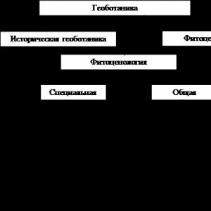
Being a complex science, geobotany is subdivided into a number of specific disciplines (Fig. 1):

Rice. 1. The structure of geobotany as a complex science.
· phytocenochorology (vegetation geography, chorological geobotany) - a section of geobotany that studies the patterns of the geographical distribution of various syntaxonomic units of vegetation on the Earth's surface; includes:
· geobotanical mapping - compilation of geobotanical maps of vegetation of various scales;
· geobotanical zoning - identification of territorial differentiation of vegetation into internally homogeneous areas with individual properties;
· phytocenology - a section of geobotany that studies the interaction of plants with each other and with the environment, the formation of the structure of plant communities and their complexes, the dynamics of these processes. It is subdivided into:
· general , which considers the general patterns of the structure of plant communities ( synmorphology), the patterns of their formation and dynamics ( syndynamics), the relationship of the components of plant communities with the environment and with each other ( synecology), as well as the classification of plant communities ( syntaxonomy);
· special - general phytocenology in relation to certain types of vegetation. Sections of special geobotany are forestry, meadow science, bog science etc., which, in turn, serve as the theoretical basis for the applied sciences of the agronomic cycle: forestry, meadow farming, bog culture, etc.
· historical geobotany - a branch of geobotany that studies the change in vegetation on a geological timescale in connection with changes in climate and the Earth's surface. When studying changes in vegetation under the influence of an anthropogenic factor, the time scales are comparable to the time of existence of human civilization - up to several centuries.
Thus, geobotany is a synthetic science. Thus, phytocenochorology is very closely related to the complex of geographical sciences and botanical geography; historical geobotany partially overlaps with paleobotany; and phytocenology intersects with floristry and plant ecology.
Geobotany is often regarded as synonymous with phytocenology, which, in our opinion, is not entirely accurate. In Central Europe, geobotany is considered in a broad scope, that is, in addition to phytocenology in a narrow sense, it includes the geography of vegetation and, sometimes singled out in a separate direction, historical geobotany. This approach seems to be the most rational; in addition, in modern literature it is being used more and more widely.
Some scientists, especially American and English, as a synonym for geobotany, quite widely use the term "synecology", which is understood as the science of plant communities. At the same time, geobotany, especially phytocenology, is considered as a part of plant ecology or the ecology of plant communities. But, as can be seen from the above diagram, in addition to synecology (ecology of phytocenoses), in addition to synecology (ecology of phytocenoses), geobotany (and phytocenology) also includes other sections: morphology, geography, classification of phytocenoses, the doctrine of the development and changes of phytocenoses, etc., and therefore synecology is only part of geobotany, albeit an important one. At the same time, ecology as a whole cannot be reduced to geobotany. The fact is that ecology is the science of the relationship between living organisms and their environment. The complete separation of geobotany and ecology as separate sciences occurred in the late 70s of the 20th century, when V.D.Fedorov (Fedorov, 1977) formulated ecological paradigm, according to which a specific, unique object of ecology is ecosystem rather than individuals, populations and even communities.
The main goals and objectives of geobotany. Geobotanical research methods
The purpose of geobotany- elucidation of the reasons that determine the patterns of grouping of plants in space and time, knowledge of the properties and qualities of the formed groups, patterns of their distribution on the globe, search for ways to manage them (improve and increase productivity, create new groups), develop a strategy for their protection and rational use ...
To achieve this goal, geobotany as a science must solve a number of specific tasks:
1) determination of the phytocenotic composition of the vegetation cover;
2) study of the floristic composition and structure of the identified phytocenoses;
3) elucidation of the dependence of the phytocenotic composition of the vegetation cover, the floristic composition of phytocenoses and their structure, distribution and spatial relationships on climatic and topographic conditions, on biotic environmental factors and the degree of anthropogenic load;
4) study of the genesis and evolution of vegetation, the dynamics of phytocenoses;
5) study of the formation, variability and changes of phytocenoses in time, depending on external and internal factors;
6) analysis of phytocenotic relations between plants depending on the conditions of existence, biological and ecological characteristics of plants and their mutual placement;
7) study of the interaction and interdependence of the phytocenosis and the environment;
8) elucidation of the state of the vegetation cover in the geological and historical past and the reflection of the past in modern vegetation;
9) the establishment of classification units of different ranks and the systematization of the types of phytocenoses, that is, the classification and systematics of vegetation;
10) economic characteristics of vegetation forms and finding out ways to improve them, more rational distribution, protection and use.
Summing up the above, one can say in the words of A. P. Shennikov that geobotany has “one task: a full-fledged phytocenological study of the vegetation cover; the listed tasks are just different sides from which the studied subject should be considered ”(Shennikov, 1964: p. 15).
In order to solve the assigned tasks, geobotany uses a whole system of methods ... There are several different options for classifying the methods used in geobotanical studies. We adhere to the scheme of BM Mirkin (Mirkin et al., 1989), which is based on the method of biological cognition - descriptive-registration (observation) or experimental, as well as the sign of the frequency of accounting. In this case, there are three groups of methods.
· Route methods one-time counts along the route. They can be of different scales and cover both small areas of vegetation and entire areas, as well as different in the degree of accuracy, that is, rely on both purely visual estimates and accurate accounting methods.
· Stationary methods- a class of methods that are implemented by multiple re-examining the same signs of vegetation at the same points. Stationary studies can be of different duration (from several days to tens of years) and can be carried out using both visual assessments (for example, multiple visits to the same vegetation sites for visual observation of fluctuations), and using a whole arsenal of sophisticated instruments. For the most part, such stationary geobotanical studies develop into ecological studies, since changes in vegetation parameters are analyzed in parallel, taking into account environmental parameters.
· Experimental methods - a class of methods that are implemented by active intervention into the observed vegetation and environment. Experimental studies include, for example, the study of the effect of fertilizers on vegetation, the creation of artificial phytocenoses, the inclusion of new components in natural communities (or their exclusion), a decrease in the level of competition by pruning tree roots, and so on. A special type of experimental research is methodological experiments, which are carried out with the aim of comparing different methods of obtaining initial data and their processing; experimental methods include modeling of phytocenotic systems.
Head of the Laboratory, Leading Researcher, Doctor of Geographical Sciences - I.A.Trofimov
Leading Researcher, Candidate of Agricultural Sciences - L. S. Trofimova
Senior Researcher - E.P. Yakovleva
Research assistant - E. V. Klimenko
Consultant, Doctor of Biological Sciences, Academician of the Russian Academy of Sciences - I. V. Savchenko
Integrated geobotanical research
Comprehensive geobotanical research at the V.I. VR Williams - the largest scientific, methodological, research and intellectual center for fodder production in Russia, have their richest, more than a century history.
The solution to the problems of increasing the adaptability, sustainability and economic efficiency of forage lands is based on their deep comprehensive geobotanical study. The founders of Russian meadow science - V.R. Williams, A.M.Dmitriev, L.G. Ramenskiy, I.V. Larin, T.A. Rabotnov considered the geobotanical study and assessment of natural forage lands to be "a necessary part of the work on grassland management." ...
The principal features of the scientific school of geobotany at the All-Russian Research Institute of Forage is the study of vegetation in relation to the environment and its assessment in terms of forage.
The main directions of activity of the scientific school of geobotany of the Institute are carried out in different directions. Development of theoretical and methodological foundations, principles and methods of an integrated (synthetic) phytopoecological approach to assessing natural forage lands, agricultural lands, agroecosystems and agricultural landscapes using ground and remote sensing data. Comprehensive geobotanical study and assessment, classification, mapping, zoning, monitoring of natural forage lands in Russia, forage characteristics of hayfields and pastures and forage resources of the studied territories, theoretical substantiation of systems for their improvement and rational use, methods of managing production, environment-forming and environmental functions of agroecosystems and agricultural landscapes ...
The geobotanical study and assessment of natural forage lands at the institute began with the beginning of the organization in 1912 of a demonstration meadow economy at the higher courses in meadow farming at the Moscow Agricultural Institute. On the basis of this farm, a station was created in 1917, the State Meadow Institute in 1922, the All-Union Institute in 1930, and the All-Russian Research Institute of Forage in 1992.
The observation of plants in nature and their herbarization from the very beginning have become an integral part of the system of studying meadows at the State Meadow Institute. The first collections of the Herbarium consisted mainly of collections on excursions around Moscow and neighboring regions. You can read more about the Herbarium.
Currently, the laboratory team (I.A. Trofimov, L. S. Trofimova, E. P. Yakovleva, I. V. Savchenko, E. V. Klimenko) is developing an agrolandscape-ecological zoning of natural forage lands in Russia.
L.G. Ramenskiy, as well as V.V. Dokuchaev and V.R. Williams, came to the conviction that the plant community is part of more complex systems - biocenosis and biogeocenosis, lands and agricultural landscapes. This position is most fully reflected in his doctrine of the types of land.
In his work "Classification of lands according to their vegetation cover" L.G. Ramenskiy pointed out that we do not need classifications of vegetation, soils, habitats, etc., separate and only mechanically superimposed on each other, we need a phytopoecological classification of lands in all the diversity and unity of their complex characteristics. This classification of land types (biogeocenoses, agrolandscapes, agroecosystems) is a complex phytopoecological, necessary for applied purposes. In essence, the classification of natural forage lands by L.G. Ramenskiy is a classification of land types, agroecosystems or agrolandscapes.
With unrelenting energy L.G. Ramenskiy advocated a comprehensive study of lands. He published a very valuable theoretical, methodological and practical manual for the comprehensive study of lands, which is the basis of a synthetic theory of natural and economic types of lands. This is the direction of L.G. Ramensky laid the foundations for the creation of a modern theory of agrogeosystems and agrolandscapes.
In his work "Introduction to a comprehensive soil-geobotanical study of lands" (1938) L.G. Ramenskiy defines the subject of research as follows: “... on the one hand, territory, land, on the other hand, plants, animals, microorganisms are the main natural factors of agriculture ... To substantiate measures, a synthetic approach is needed - it is necessary to study soils, vegetation, water balance territory, its microclimate, etc., in their mutual connection, in interaction, against the background of cultural regimes and transformations. The synthetic study of the natural features and life of the territory in the perspective of its economic use and transformation is the content of the industrial typology of lands. The method of land typology is a comprehensive study of the territory ... ". These systemic (agrolandscape) approaches and traditions are sacredly preserved and developed at the All-Russian Research Institute of Forage.
Today, not only the school of geobotany of the All-Russian Research Institute of Forage is based on these principles, the leader and founder of which was Leonty Grigorievich Ramenskiy, on these principles modern agrolandscape science and the study of agroecosystems are based - promising modern scientific directions developing at the intersection of agricultural science, geobotany, landscape science and ecology.
Modern studies have confirmed that the preservation of valuable agricultural lands and soil fertility is possible only if favorable conditions are created for productive longevity of agricultural landscapes, soil formation and development of soil biota, and ensuring the active life of the main soil formers - perennial grasses and microorganisms.
Perennial herbal ecosystems perform the most important production, environment-forming and environmental functions in agricultural landscapes and have a significant impact on the ecological state of the country's territory, contribute to the preservation and accumulation of organic matter in the biosphere. Thanks to perennial grasses, fodder production, like no other branch of agriculture, is based on the use of natural forces, reproducible resources (energy of the sun, agricultural landscapes, lands, soil fertility, photosynthesis of herbs, creation of biological nitrogen from the air by nodule bacteria).
The role of forage production and, first of all, grassland farming and the culture of perennial grasses in modern conditions, with limited financial and material resources, is even more growing. The requirements for preserving soil fertility, ensuring the productivity and sustainability of agricultural lands, greening and protecting the environment highlight the biologization and adaptive intensification of agriculture.
The priority development of fodder production, which is inextricably linked with an increase in the sustainability of agricultural landscapes, also focuses on the need for a more complete use of inexhaustible reproducible natural resources and “free forces of nature” through biologization and ecologization of intensification processes in agroecosystems and agricultural landscapes.
The modern system of management and design of agricultural landscapes is based on the dominant principle of the unity of economy and ecology, harmonization of relations between man and nature in the process of agricultural production.
The strategy of adaptive agricultural nature management in the 21st century is the purposeful optimal spatio-temporal organization of modern agricultural landscapes, which should be most adequate to their natural structure and dynamics.
The developed system of study, management and design of agricultural landscapes is based on the dominant principle of the unity of economy and ecology, harmonization of relations between man and nature in the process of agricultural production. The main rule of balanced interaction between Man and Nature is the preservation of natural ecosystems, valuable agricultural lands and soil fertility, which is possible only when creating favorable conditions for the functioning of agricultural landscapes, ensuring a balance of productive and protective agroecosystems, the active life of the main soil formers - perennial grasses and microorganisms, favorable conditions for soil formation and development of soil biota.
One of the essential tasks of educational practice, in addition to acquaintance with the most typical plant communities in the territory of its conduct, should be considered the development of the methodology for performing geobotanical descriptions, which are the basis of any geobotanical research. The study of terrestrial phytocenoses is carried out trial plots method- specially designated areas.
For our purposes, such a site is selected in the most characteristic, typical place for a given association, away from roads, clearings and other disturbances of the natural vegetation cover, as well as from borders with other associations. The test site is in the shape of a square, the size of which is not the same for individual types of vegetation. So, when studying forests of the temperate zone, it is customary to lay test plots of 400 m 2 (20 x 20 m), and when describing herbaceous vegetation - 100 m 2 (10 x 10 m). If the phytocenosis is small (less than the indicated area), then it is described within the natural boundaries with an indication of the size.
The contours of the test site are indicated either with the help of pillars and poles (if it is planned to make this site stationary), or with chalk on tree trunks, bright rags in the corners of a square in a meadow, etc.
After laying the trial plot in a specially prepared form, put it down size, serial number geobotanical description , day, month and year work, as well as the names of the authors of the description. If necessary, indicate the appropriate profile number. We emphasize the extreme importance of all these seemingly insignificant points - any description loses its objectivity in the absence of an indication of the time of its execution or the size of the trial plot. For example, the absence or presence of some plant species, their phenological state and a number of other characteristics of the phytocenosis depend on the date of the description.
Further, information about geographic location of the investigated area - an indication of the administrative units of the place of work (region, district), as well as more detailed landmarks - the distance and direction from the nearest settlement - a village, village or other geographical object - a river, lake, mountain peak, etc., allowing localize the gathering point with an accuracy of several km (preferably within a circle with a radius of 1–2 km).
Some of the most important characteristics of the environment that need to be noted in the study include relief description or, in scientific terms, the geomorphological conditions of the terrain. The main forms of relief are plains (the slope is not more than 0.5 °), hills (up to 200 m relative height), mountains (more than 500 m) and slopes. The slopes are characterized by steepness: gentle (slope 2–7 °), sloping (7–15 °), steep (15–45 °) and steep (slope over 40 °). In addition, if the test site is located on a slope, it is necessary to note its exposure and the location of the site in relation to its foot or top.
When carrying out the description, first of all, the elements should be marked macrorelief(horizontal strike from 200 m to 10 km and more). These elements include, for example, a mountain range, a river valley, a watershed between two adjacent rivers, etc. The next in terms of dimension are the forms mesorelief(the diameter of which is measured in tens or a few hundred meters, and the difference in heights is in meters). These are terraces, manes and hollows of the floodplain, small sand ridges, hollows and gullies on the slopes, dunes, moraine hills, ravines, etc. The smallest landforms, the dimensions of which do not exceed several meters, are called microrelief... These include, in particular, saucer-shaped wall depressions, river-bed ramparts, depressions and depressions, low sandy hills, etc.
Another important indicator of habitat conditions is the type and degree of moisture. . Humidification type depends on the position of the trial plot in the relief and is determined by the prevailing source of water supply (atmospheric, drip, ground). Depending on this, 9 main types are distinguished (Fig. 4).
Rice. 4. Scheme of the main types of locations: a) upland (eluvial); b) transeluvial; c) accumulative-eluvial; d) flowing watersheds; e) eluvial-accumulative; c) key; g) super aquatic; h) floodplain; i) subaqueous
Plakorny(eluvial) type of humidification is characteristic of watershed surfaces with slight slopes (1–2 °), on which there is no significant surface runoff and atmospheric humidification prevails. Transeluvial This type is observed on the upper, relatively steep (not less than 2–3 °) parts of the slopes, also fed mainly by atmospheric precipitation, but with an intense runoff and flat washout. Accumulative-eluvial type typical for closed or semi-drainage watershed depressions (depressions) with difficult runoff and additional water supply due to runoff waters; In this case, the groundwater still remains at a considerable depth. Flowing the type is generally similar to the previous one, but drainage depressions and valleys have a free runoff. Eluvial-accumulative The (deluvial) position is characterized by abundant moisture due to the dripping waters flowing down from above and is confined to the lower parts and foothills of the slopes. In Group super aquatic types of moisture emit key(transsuperaqual), characteristic of the places where groundwater flows to the surface, and proper super aquatic in conditions of low-drainage depressions with a similar level of groundwater (waterlogging and salinization are observed here). A special type is floodplain humidification, characterized by regular and usually flowing flooding during floods or floods, and therefore by variable water regime. The last type bearing the name subaquatic Are underwater habitats.
In determining degree of moisture usually guided by soil moisture. In this case, five steps are distinguished: 1) dry the soil is dusty, the presence of moisture in it is not felt to the touch, does not cool the hand; 2) damp soil - it cools the hand, does not get dusty, when it dries it brightens a little; 3) wet soil - moisture is clearly felt to the touch, the sample moistens the filter paper, when it dries, it brightens significantly and retains the shape given to it when squeezed by hand; 4) raw soil - when squeezed in the hand, it turns into a pasty mass, and water wets the hand, but does not ooze between the fingers; 5) wet soil - when squeezed in the hand, water is released from it, which oozes between the fingers, the soil mass shows fluidity. You can also limit yourself to general indications of the degree of moisture: normal, excessive, insufficient.
Further, in the description, the thickness of the layer is noted dead litter(in centimeters), the composition of its constituent components (needles or leaves of tree species, felt of steppe cereals, etc.), the degree of coverage and the spatial severity of this layer in a given phytocenosis (evenly distributed, fragmentarily, spots near tree trunks, etc.) .).
Particular attention must be paid to the characteristics anthropogenic influence on the phytocenosis, noting the main forms of economic activity, if any (for example, hay or pasture land, logging with an indication of its age, reclamation measures), the presence of paths and roads, the proximity of settlements, etc. As additional comments to the characteristics of the environment, any specific features of the habitat are noted (for example, the presence of outcrops of carbonate rocks, the presence of moraine boulders, fluttering sands, etc.).
After a brief description of the habitat conditions, one goes to description of its own vegetation by tiers. For forest communities, this description begins with the stand. The first step is to determine general closeness(projection) crowns... The light regime under the forest canopy depends on this indicator, it also gives an idea of the density of the stand. The degree of crown closure is determined visually in fractions: a unit is taken to be such a degree of closure when the gaps between the crowns are either practically absent or do not exceed 0.1 (10%) - accordingly, the sum of crown projections occupies more than 0.9 (90% of the area) , gaps inside the crowns themselves are not taken into account. And the degree of closeness of 0.3, for example, means that the closeness of the crown of the stand is only one third of the total. For an objective determination of this indicator, one cannot limit oneself to its value in one place of the test site - it is necessary to conduct several visual counts. Only after this is the final conclusion made.
The next step is to establish the species composition of the stand, for which all the noted tree species are entered into the description, preferably in the order of their dominance. After that, the height of each species (breed) and its belonging to a certain understage... The identification of substages is usually necessary in communities with a complex stand formed by several tree species - where there are two or three of them (substages). In this case, the upper substage is formed by trees of the first size (for example, pine, spruce, fir, birch, oak), and the lower (lower) - lower, second size (mountain ash, bird cherry, pear, alder, etc.).
In such a description of the vertical structure of the phytocenosis, one should take into account the possibility of the presence of trees in it that have not reached the adult state. These young plants, which are only temporarily included in the lower substage, should not be included in it. V.N. Sukachev proposes to classify them as canopies (temporary tiered structures). In this case, the record of the longline position of the view will look like this:
This means that European spruce is included in the 1st substage, and in the 2nd or 3rd stage it forms canopies; common linden is included in the 2nd substage, but some of its specimens are temporarily present in the 3rd substage.
Height trees can be defined in several ways. The simplest is the eye. To do this, a certain height is marked on the tree trunk from the base (for example, 2 m), and then, moving away from the tree by 10–20 m, mentally postpone this distance along the trunk up to the top. There are, however, and more accurate methods of measuring heights using an eclimeter or altimeter. Detailed characteristics of the design of these devices and measurements with their help can be obtained in the manuals attached to the individual models.
The average height of a rock in a particular phytocenosis is determined as the arithmetic mean of several trunks with an average diameter.
After carrying out the required number of measurements of heights, proceed to measurements trunk diameters... It is convenient to measure this indicator using a caliper, which consists of a measuring ruler with divisions in centimeters and two bars, or legs (Fig. 5).

Rice. 5. Measuring the diameter of the barrel with a caliper
Each tree is measured strictly at a height of 1.3 m, i.e. approximately at the level of a person's chest. If the trunk has an irregular cross-section, the diameter is determined in two perpendicular directions and the average is calculated. In the absence of a caliper, determine the circumference of the tree using a soft tape measure, and then divide the resulting value by 3.14 (p-number). For educational purposes, one can completely limit oneself to measuring several trunks dominating in thickness for each tree species with the calculation of the arithmetic mean.
The next step is to define age groups tree stand. Since the absolute age of trees can only be determined by counting tree rings on fresh stumps or, for standing specimens, using a special Pressler drill, for educational purposes it is advisable to limit the classification of forest stands to the so-called age classes... For conifers and broad-leaved species, the age class is defined by a period of 20, and for small-leaved species - at 10 years. The main age groups are the following: young stands, pole stands, middle-aged, ripening, mature and over-mature forests. In coniferous forests, young stands are up to 20 years old, perch stands are 21–40 years old, middle-aged ones are 41–60 years old, mature stands are 61–80 years old, and ripe stands are 81–100 years old. In deciduous forests, the corresponding values are for young stands up to 20, pole stands - 21–40, middle-aged - 41–80, ripening - 81–100, ripe - 101–120 years. In small-leaved forests, birch and black alder stands are young up to 10 years old, pole stands at 11–20, middle-aged at 21–40, ripening at 41–50 and ripe at 51–60. Among aspen forests, mature stands are already considered to be 41–50 years old, and in gray alder stands, they are 26–30 years old. Plantings are considered overmold if they have basically stopped growing, acquire signs of aging, become sick and die off.
After that, a count is made on the trial plot number of trunks each breed. To avoid counting errors, a chalk mark is made on each counted trunk. Next, the proportion of each tree species is calculated and stand composition formula.
Individual tree species are designated by the first letters of their names. The following abbreviations are generally accepted: C - Scots pine; E - common spruce; D - pedunculate oak; Cl - Norway maple; Lp - small-leaved linden; Os - aspen; B (b) - warty or drooping birch; B (p) - white birch, or fluffy; Ol (h) - black alder; Ol (s) - gray alder; H - bird cherry.
The participation of each species in the stand is calculated as a percentage, divided by 10 and rounded to the nearest whole value. If the participation of a species is less than 10%, in the formula the presence of this breed is indicated not by a number, but by a “+” sign.
Let's consider an example... On the trial site, 212 trees were counted, including 144 pines, 36 spruces, 27 birches and 5 individuals of gray alder. Thus, the share of pine is 67.9%, (i.e. 6.8, rounded - 7), spruce - 17% (2), birch - 13% (1), and alder - 2% (+). The formula for the composition of the stand in this case will look like this: 7C2E1B (b) + Ol (c).
After studying the stand, proceed to the characteristics renewal breeds (seedlings and undergrowth). In forestry practice, seedlings are considered to be one-two-year-old trees (they include all plants up to 10 cm in height), and undergrowth - those that have not reached a quarter or half of the height of adult trees. Many of them will die in the future in the struggle for existence, and the stronger ones will eventually reach the height of the upper tier and take the place of the modern stand. The description of the renewal is to establish the degree of its closeness(similar to how it is done for trees), breed composition, and then for each breed - the predominant heights, the dominant age(if necessary, you must specify its lower and upper limits), fortunes(the degree of trustworthiness, i.e. the possibility of achieving an adult state in these conditions).
Abundance it is convenient to evaluate the renewal on a four-point scale: 1 - the renewal is unsatisfactory (up to 2000 ind./ha); 2 - weak regeneration (2000–5000 ind./ha); 3 - the recovery is satisfactory (5000–10000 ind./ha); 4 - good regeneration (more than 10,000 ind./ha). It is also important to note the regeneration method, i.e. the origin of seedlings and undergrowth, which is either seed or vegetative (in the form of overgrowth on stumps or offspring on the roots of adult trees.
In many types of forest communities, the development of shrub layer(undergrowth), the study of which also begins with the definition degree of closeness, representing a horizontal projection of all above-ground parts of the shrubs. After that, the characteristics of all the rocks that make up the undergrowth are consistently given. The characteristics of each of them include the predominant height, abundance, phenophase and nature of placement... We will dwell on the description of indicators that have not yet been encountered (abundance, phenophase and nature of distribution), and in relation to shrubs, we note another value necessary in the description - the total number of bushes per unit area... The determination of this indicator, which serves as an expression of the density of the undergrowth, is reduced to counting the total number of specimens of shrubs (without differentiating their species) on a square area of certain sizes (most often 25 or 100 m 2 - depending on the size category of the dominant species) within the trial plot.

Rice. 6. Ramensky grid
Feature grass-shrub layer in the forest and in the swamp or herbal in the meadow, they also start by defining general projective cover- horizontal projection of aboveground parts of plants on the soil surface. In this case, the ratio of plant projections (minus the gaps between leaves and branches) to the total area taken as 100% is visually taken into account. The accuracy of calculating the projective cover can be significantly increased by splitting the trial plot into smaller areas: in each obtained square, the cover is taken into account separately, and then the average value is determined. For the same purpose, geobotanists use the so-called Ramensky grid(Fig. 6), which is a small plate in which a rectangular hole measuring 2 x 5 or 3 x 7.5 cm is cut. The hole is divided with a white thread or thin wire into 10 square cells (cells) of 1 or 1.5 cm 2 each one. Considering the grass stand through such a mesh hole, it is determined how many cells (i.e., tenths of the hole) are in the projection of the vegetation and how many are on the bare soil surface penetrating through the grass stand. At the same time, projections or empty gaps are mentally clustered to one end of the mesh. Repeated counts of the coverage in different places of the trial plot make it possible to obtain the average value of this indicator with a fairly high accuracy. The developed standards of projective cover gradations help in this (Fig. 7).

Rice. 7. Standards of the gradation of the projective cover (in%) of the grass stand, considered in the Ramenskoe grid
Another important indicator, determined when characterizing the herb-dwarf shrub cover, is the true coverage (or coverage with the bases of plants, turf), which should be distinguished from the previous indicator. With the same projective cover, sod cover can vary greatly (Fig. 8). Using the eye method, the true coverage is determined by pushing the grass stand with your hands. To obtain more accurate values, a 1 m ruler is used, which is placed on the soil surface.

Rice. 8. Stem base area and projective cover: outer circles (dotted line) - maximum leaf coverage, inner (solid line) - plant bases
Along it, all plant bases falling on the line are measured in centimeters, which in this case corresponds to the percentage of coverage. Several such measurements make it possible to calculate the average true coverage.
In addition to the projective and true coverings of plants, aspect, representing the appearance (physiognomy) of the community. In this case, the color and the list of plants that form it are indicated. For example: the aspect is green with white spots of a blooming mine; aspect of yellow buttercup pungent, etc.
After fulfilling the general characteristics of the herbaceous cover of phytocenosis, they proceed to identifying floristic composition trial plot and characteristics of each species of its constituent plants. It is best to start compiling the list of species from one corner of the site, first writing down all the plants that fall into the field of view. Further, slowly moving along the sides of the square, the list is supplemented with new species and only after that they cross the trial plot diagonally. You should look very carefully at the grass stand, since not all plants can be seen from the height of human growth. Many of them, the smaller ones, are well hidden under the leaves and stems of large grasses and they can only be detected when the grass stand is pushed apart with hands and when you examine the most hidden corners.
After the compilation of the list of species as a whole is completed, you can start assigning them to one or another sub-stage. In some cases, the identification of the tier structure of the herbaceous cover is a rather difficult matter, and then it is best to restrict ourselves to only indicating the height of the plants and the upper level of the densest phytomass. In cases where individual tiers are well differentiated from each other, they are numbered from higher to lower and for each indicate dominant types and heights of development.
The degree of participation of certain species in the herbage is determined by the methods of accounting for their relative abundance... The most common of these methods is the use of the Drude scale (Table 1), in which various degrees of abundance are designated by points based on the values of the smallest distances between individuals of the species and their occurrence.
TABLE 1. Scale of abundance estimates according to Druda (with additions by A.A. Uranov)
Points Litter (copiosae) at the same time, abundant plants are indicated, the average minimum distance between individuals is no more than 100 cm. As a result, plants also have a high occurrence - not less than 75%. In this case, large and medium-sized plants usually play a significant role in the general appearance (physiognomy) of a phytocenosis or a separate layer, becoming completely or partially background. Within this score, three levels are distinguished:
wp3- very abundant, the average minimum distance is no more than 20 cm. The occurrence is therefore, as a rule, 100%. Such plants usually (with the exception of very small plants) form the main background of vegetation or a separate layer;
wp2- Abundant, average minimum distance - from 20 to 40 cm. Occurrence sometimes (with somewhat uneven distribution) is slightly below 100%. Such plants often, especially in the absence of others, more or equally abundant, but larger, play the main or at least a significant role in the physiognomy of the association site, creating a continuous background;
cop1- quite abundant, the average minimum distance is from 40 to 100 cm. The frequency of occurrence usually does not fall below 75%. The role of such plants in the appearance of the site is less, they do not constitute a background, but they can significantly affect the appearance of vegetation, presenting numerous inclusions in the mass of herbage, especially noticeable with a specific form of growth or large sizes of individuals.
Point Sp (sparsae) scattered plants are noted, the average minimum distance between which is 1–1.5 m. They are found almost at every 1–2 steps, but, as a rule, they do not form a background (with the exception of very large plants) and only have physiognomic significance in the herbage. in case of noticeable contrast with others.
Single plants are indicated by a score Sol (solitariae). They are far apart from each other - the smallest distance is always more than 1.5 m. The occurrence is low, not higher than 40%. These plants do not have a background value, although sometimes, differing in their growth form, bright color and size, they are quite noticeable among the rest.
In the case of fluctuations in the abundance between two steps, sometimes combined estimates are used, for example, sol – sp, sp – cop1, etc.
Suffering from inaccuracy and significant bias in the data obtained, the Drude scale for determination is extremely simple and easy to use. However, it should be remembered that this method is suitable only for a schematic, largely subjective, determination of the relationship between species and the selection of the main species from the general mass. An idea of how the results obtained using the Drude scale compare with other, more accurate methods can be obtained by considering table. 2.
TABLE 2. The value of the points of the Drude scale
| Scale gradation name | The number of individuals per 1 m 2 (lower left part of the table) or 100 m 2 (upper right part of the table) with an average coverage of one specimen | The proportion of coverage by all plants of a given species (%) | |||||
| latin | Russian | up to 16 cm 2 (4 x 4 cm) | up to 80 cm 2 (9 x 9 cm) | up to 4 dm 2 (20 x 20 cm) | up to 20 dm 2 (45 x 45 cm) | up to 1 m 2 (100 x 100 cm) | |
| sol | singularly | up to 20 | up to 4 | – | up to 0.16 | ||
| sp | absently | up to 5 | up to 20 | up to 4 | up to 0.8 | ||
| cop1 | pretty abundant | up to 25 | up to 5 | up to 20 | up to 4 | up to 4.0 | |
| cop2 | profusely | up to 125 | up to 25 | up to 5 | up to 20 | up to 20.0 | |
| cop3 | very abundant | more than 125 | more than 25 | more than 15 | more than 5 | more than 1 | more than 20.0 |
The abundance scores are complemented by indications of nature of placement plants in the community. In the case of uneven distribution, this feature is indicated by the following icons: gr- Plants grow in dense clusters (groups), within which there are no or almost no individuals of other species; cum- Plants grow in loose clusters, where many individuals of other species live among the main species.
Under phenophase or the phenological state of a plant means one or another phase of its development. For their designation in the description of phytocenosis, the system proposed by V.V. Alekhin (1925) - tab. 3.
TABLE 3. The phenophase designation system according to V.V. Alekhine (with additions)
| Phenophase | Characteristic | Letter designation | Symbol |
| Vegetation before flowering | The plant only grows, is in the rosette stage, begins to give a stem | Veg. | – |
| Budding (in cereals and sedges - heading) | The plant has thrown out a stem or arrow and has buds | Color | ^ |
| The beginning of flowering (sporulation) | The plant is in the blooming phase, the first flowers appear | Father. | E |
| Full bloom (sporulation) | Plant in full bloom | Booth. | O |
| Fading (end of sporulation) | Plant in the phase of flowering | Zatsv. | WITH |
| Ripening of seeds and spores (fruiting) | The plant has faded, but the seeds are not yet ripe and do not spill out | Pl. | + |
| Sprinkling of seeds (fruits) | The seeds (fruits) are ripe and are spilling out | Os. | # |
| Secondary vegetation | The plant grows after flowering and rash of seeds (fruits) | Tue veg. | ~ |
| Withering away | Aerial shoots (for annuals - the whole plant) die off | Mark | V |
| Dead shoots | Aerial shoots or the whole plant is dead | M. | X |
When characterizing moss and lichen cover the percentage of soil coverage with mosses is noted - general and by type. It is also very important to show the nature of the distribution of mosses and lichens, which depends on the microrelief, the influence of the crowns of trees and shrubs, fallen trunks, etc., as well as the substrate on which they grow.
In conclusion of the field description of the phytocenosis, a characteristic is given of extra-tiered plants (lianas and epiphytes), represented in the forests of the middle zone mainly by mosses and lichens, less often by climbing liana-like grasses. When describing the phytocenotic role of these plants, it is important to indicate their abundance(in conditional points), attachment height and substrate... A note indicates any special features in their placement, if any.
Finally, in the section "General remarks for the entire phytocenosis", it is worth noting the connections with environmental conditions noted during the work, the conclusion about the primary or, on the contrary, the secondary nature of the modern vegetation cover of the test site, note the influence of the upper tiers on the lower ones, cite the established indicator plants and etc. - in a word, all those observations that will facilitate the further processing of numerous forms of descriptions.
III. Phytocenosis
Following the generally accepted definition of V.N. Sukachev, we will call phytocenosis "any set of higher and lower plants living on a given homogeneous area of the earth's surface, with only their own inherent relationships, both among themselves and with habitat conditions and therefore creating their own special phyto-environment." For the manifestation of the influence of plant individuals on each other, it is necessary, first of all, their joint growth. Thus, extremely scattered or detached plants cannot be called phytocenosis.
How to distinguish one phytocenosis from another in nature? In a general sense, a phytocenosis should be understood as an area of vegetation that is qualitatively unique and different from its neighbors. A.A. Nitsenko indicates the following main criteria that should be used as diagnostic signs for determining the boundaries of phytocenoses: constancy of the structure of the vegetation cover in space; community of dominants (dominant in the number of plants) of the main tiers; a similar comparative role of different ecological groups, including life forms, in the composition of accompanying species (if there are any accompanying species).
Let us dwell briefly on the characteristics of these main features.
Under phytocenosis structure understand the peculiarities of the spatial arrangement of plants in the horizontal and vertical directions. Reflection vertical dismemberment phytocenosis serves tiered... Plants of the same height are in equivalent lighting conditions, forming separate above-ground layers, which allows them not to enter into direct competition with plants of other height levels. The same can be said for the distribution of root systems of individual species. Some plants have a superficial fibrous system that allows them to absorb moisture that comes with precipitation or even dew, others have their roots in the entire soil layer and use the water accumulated in it, while others pull their long taproot sometimes for many meters to a level groundwater is a more permanent source of moisture. Thus, the layering allows a fairly significant number of species that differ in their ecological requirements to exist in the same area.
The ratio of the significance for the phytocenosis of underground and aboveground layers largely depends on the external environment. In forest phytocenoses, the aboveground layering is best expressed, since with sufficient moisture, the main competition between plants is for the illumination regime. Note, however, that it is legitimate to distinguish the tiers only when the plants included in their composition are sufficiently numerous and have a certain degree of closeness. There is also the so-called off-level vegetation in forest communities, which includes vines and epiphytes (plants that settle on the trunks and branches of trees).
In herb-semi-shrub communities of more arid areas (for example, in steppes and deserts) and in individual meadow cenoses, where illumination conditions are quite sufficient, and the main competition between plants is for the use of moisture, the value of underground phytomass sometimes exceeds the aboveground one by tens of times. Accordingly, in these communities, with a weakly expressed aboveground layering, the underground layer is well expressed (Fig. 9). It is especially pronounced in deserts and semi-deserts, less so in meadows, for which, instead of the term "tier", it is sometimes suggested to use the concept of the rooting depths of individual groups of species, which, in essence, is about the same.

Rice. 9. Root layers in the association of longline on gravel talus at an altitude of 2260 m, Swiss Alps:
1 - round-leaved yarrow; 2 - triseta; 3 - violet; 4 - mountain kulbaba; 5 - resin.
I - horizon of coarse gravel; II - horizon of absorbing roots; III - the horizon of the attaching roots
Heterogeneity (heterogeneity) of phytocenoses in horizontal direction bears the name mosaics and is caused, as a rule, by the biology of reproduction, the nature of the distribution of seeds, the forms of growth of certain plant species (for example, spots of acid or mine in a spruce forest arise as a result of their intensive vegetative reproduction) and their mutual relations. Often, more or less pronounced spots of plant cover within a phytocenosis can arise due to the uneven distribution of a strong habitat-forming plant (edificator of the phytocenosis) in space, to which the rest of the community components are “adjusted” (attracted or repelled). A similar effect of the formation of microgroups (in another terminology - microphytocenoses) is well traced for the example of forests. So, for example, in the larch forests of Yakutia, green mosses grow on the soil under the crowns of trees, and lichens grow in the windows. In the spruce-broad-leaved forests near Moscow, the subcrown space of oak trees corresponds to the groupings of hairy sedge, aspen - May lily of the valley, gray alder - hard-leaved starlet, and spruce - respectively, common sour.
Complexes of phytocenoses, which owe their existence to variations in the characteristics of the external environment (ecotope), should be distinguished from mosaic phytocenoses. This complexity consists in a more or less regular alternation - depending on the soil and geomorphological conditions - of communities little dependent on each other, occupying larger areas and not united by a common layer. Complexes of phytocenoses are widespread in semi-deserts and northern deserts, in many types of tundra, and in the middle zone - in floodplain meadows and raised bogs (for example, a ridge-hollow complex).
The most significant scientific results that can be achieved in the period up to 2030 include: the creation of systems for monitoring, assessing and forecasting the state of the environment, natural and man-made emergencies; promising technologies for prospecting and prospecting for mineral resources; highly effective safe methods of offshore exploration and production of hydrocarbons in extreme natural and climatic conditions. Their development and implementation will lead to a more rational use of the country's mineral resource base and an increase in the efficiency of its reproduction, a decrease in the level of environmental pollution, and minimization of damage from natural and man-made disasters.
In the medium term, research and development in the field of environmentally friendly materials and products will be actively pursued; software and geographic information systems; equipment and materials to improve the efficiency of mining and processing of minerals; early detection and forecasting of natural and man-made emergencies.
1. Preservation of a favorable environment and ensuring environmental safety:
Study of climate change and extreme climatic events using promising approaches to the analysis of climate-forming factors.
Reconstruction of the retrospective and assessment of the modern dynamics of the cryosphere, incl. permafrost and glaciers, as well as the forecast of its changes.
Formation of a forecast of the transport and transformation of pollutants in the environment, including micro- and nanoparticles.
Assessment of changes in the ecological state of the landscape and its components, erosion-channel processes, biogeochemical flows, bioproductivity and biodiversity, as well as water bodies and their systems.
Assessment and forecasting of the complex impact of natural and man-made factors on the health status and livelihoods of the population in a changing climate and environment.
Development of systems for the rational use of natural resources in cities and agglomerations, the location of the economy and the population.
Optimization of territorial planning schemes in accordance with the landscape structure and ecological resource potential.
Expected results: reduction of the level of negative impact of economic activities (generation of production and consumption waste, emissions of pollutants into the air, discharges into water bodies) on the environment and public health; development and application of world-class environmentally efficient technologies in the main sectors of the economy.
2. Monitoring of the state of the environment, assessment and forecasting of natural and man-made emergencies:
Assessment of the state and dynamics of resources of water and terrestrial ecosystems, restoration of the resource potential of territories with a high anthropogenic load (soil, water and biological resources).
Environmental monitoring and forecasting of the state of the natural environment in large industrial cities and in specially protected natural areas of coastal zones, water areas and groundwater.
Technologies for instrumental control of emissions / discharges of pollution into the atmosphere, water bodies, soil.
Technologies for obtaining, transmitting and using information about the state of the environment and its changes using ground, air, space and other means.
Technologies and systems for early detection and forecasting of natural and man-made emergencies.
Technologies for ensuring the safety of industrial and energy hazardous facilities, incl. chemical and petrochemical industries, mining enterprises, high-pressure dams and hydroelectric and nuclear power plants.
Technologies for managing environmental risks in the development of offshore oil and gas fields in water areas, incl. ice covered areas.
Technologies for creating and updating cadastres of territories and water areas with the highest level of environmental risk.
Technologies and systems for the prevention of transboundary negative environmental impact.
Expected results: systems for monitoring, assessing and predicting the state of the environment, natural and man-made emergencies, climate changes, necessary for the subsequent introduction of modern technologies to reduce the level of negative impact on the economy and public health.
3. Subsoil exploration, prospecting, exploration and integrated development of mineral and hydrocarbon resources, as well as technogenic raw materials:
Prospecting and exploration work, incl. development of geophysical methods for oil and gas exploration in unconventional geological conditions, assessment of the productivity of oil-bearing strata, methods of searching for zones of possible ore occurrence in new production areas that meet economic and environmental requirements.
Enhanced oil recovery methods, including directed change in reservoir properties of reservoirs, which makes it possible to increase the recovery factor of hydrocarbons, incl. in depleted fields and low-pressure gas fields.
Utilization of associated petroleum gas.
Obtaining and using non-traditional sources of raw materials, incl. hydrocarbon, including "heavy oils", gas hydrates, shale gas, etc.
Physicotechnical and physicochemical technologies for processing high-gas-bearing coal seams with the prevention of mine methane emissions, incl. for the production of gaseous and liquid synthetic hydrocarbons.
Technologies for efficient processing of solid minerals, including energy-saving complex processing of refractory natural and technogenic mineral raw materials with a high degree of concentration of mineral complexes.
Industrial use of wastes from mining and processing of minerals.
Expected results: rational use of the mineral resource base and its reproduction thanks to modern technologies for prospecting and prospecting for mineral resources, incl. ensuring an increase in hydrocarbon reserves, primarily oil.
Geobotanical research, being the main form of work of field botanists, includes a comprehensive study of both the plants themselves and their habitats, which have a mutual influence and, to a certain extent, "shape each other".
This is due, first of all, to the fact that the growth of both individual plant species and the phytocenoses formed by them directly depends on a complex of physical and geographical factors, primarily on the features of the relief, soils and parent rocks of a given territory. At the same time, the role of relief is especially great, which, albeit indirectly, affects vegetation and, being a powerful transformer of heat and moisture, has an exceptionally great influence on the specificity of phytocenoses and their distribution.
In turn, the plants and the phytocenoses formed by them change their habitat - the macro- and microclimate, the composition, structure and moisture content of the soil, the underground and surface hydro-network. Being functionally related to a complex of physical and geographical conditions, plants and their communities can be used as indicators (especially species and phytocenoses with a narrow ecological amplitude) of various features of natural conditions - aeration and soil moisture, its salinity, carbonate content and texture, depth of soil and groundwater, etc. The most reliable indicators are not individual species, but groups of species or entire plant communities.
This methodological manual is devoted to the methods of studying flora, as a complex of growing plant species, and plant communities - phytocenoses.
Basic Concepts and Terms Flora and Floristic Research
Flora is a collection of all plant species growing on the territory. The concept of flora is not an analogue of the concept of phytocenosis (community); rather, it is a formal list (list) of species of a particular locality.
The study of the characteristics of the flora constitutes the subject floristic research .
Without knowledge and inventory of flora, it is impossible to conduct geobotanical research. Thus, floristic research, floristry, is part of geobotanical research.
Phytocenosis and Geobotanical Research
In geobotanical studies, the main object of study is phytocenosis .
In the domestic geobotanical literature, the most widely used definition is given by V.N. Sukachev: " A phytocenosis (plant community) should be understood as any set of plants in a given area of the territory, which is in a state of interdependence and is characterized both by a certain composition and structure, and by a certain relationship with the environment ...".
Thus, a phytocenosis is not a random collection of plant species, but a regular set of species that have adapted, as a result of long-term selection, to coexistence in certain environmental conditions.
Often, instead of the term "phytocenosis", the term "plant community" is used. However, according to A.G. Voronov (1973), it is more expedient to preserve the term "phytocenosis" to designate specific areas of vegetation, and use "plant community" as a term that does not have a definite scope, as a rank-free concept to designate any taxon in the classification of vegetation cover.
Sometimes, as a synonym for the term phytocenosis "some researchers use the term" site of association ".
Each phytocenosis is characterized by a certain set of traits, of which the following are most important for differentiating some phytocenoses from others:
1) species (floristic) composition;
2) quantitative and qualitative relationships between plants, which are determined by different degrees of participation (abundance) of different species and their unequal importance in the phytocenosis;
3) structure - vertical and horizontal dissection of the phytocenosis;
4) the nature of the habitat - the habitat of the phytocenosis.
The totality of all phytocenoses of a certain territory is called vegetation, or vegetation cover of a given territory.