Strait between England and France on the map. La Mans (Strait) Where is it? Geology and the history of the development of the strait of La Mans
In anticipation of six years from the moment of swim through La Mans, I decided to lay out some of the materials from my old site Paulkuz.ru, updating them and supplying them with comments. There will be several posts with pictures. So, if anyone is not interested - do not read.
So, for a start about what La Mans and swims through it (such as, help).
Strait of La Mans (Duvrian Strait, English Channel, Pa de Calais) - Classic Distance for Marathon Swimming. For the first time officially crossed in 1875 by the captain of the British Fleet of the UK Matthew Webb.
Matthew Webb sailed Brass (the crown was not yet invented), fed in the way with broth, and crossed the strait in 21 hours 45 minutes!
Since then, over 138, a little more than 1000 people successfully swam the strait (some in two and even three directions without stopping). Among them, until recently there was not a single citizen of Russia, the USSR or the Russian Empire. In recent years, several dozen attempts are made every season - approximately 65-70% of them are successful.

Monument to the swimmers through La Mans in the Bay of Dover. Please note: they are floating with a crawl and in both directions.
Popping takes time from 6 h. 58 min. (Fine as long as the record of 2007) to 26+ hours, usually from 12 to 16 hours. Time depends not only on the swimmer, but also no less than the weather and skill of the pilot of the boat of accompaniment. The swim is registered by representatives of the Navigation Association through La Mans (CSA), exists since 1926) or the Federation of Swimming and Piloting Federation (CS & PF) has existed since 1998) with mandatory Hiring a boat with a team of escort, which ensures the safety of swimmer, navigation, food and psychological support, as well as the return of the swimmer to the start place. Without the presence of representatives of the Association or Federation, the swim is not registered.

An example of messages from the support team that swimmer sees lateral vision.
IMPORTANT: This is not competitive, but single (Solo Swims) swims. The last time the competition through La Mans was held in the early 50s and now, by virtue of intensive shipping in the strait, their conduct is impossible. In addition to solo swims, relay swims are also held (from 2 to 6 people, each is floating in turns of 1 hour, the rest are waiting on the boat), but this is a special discipline.

An example of a bad well-being of a swimmer waiting for its turn during a relay in a swim through La Mans.
The start time of the swim as a whole is determined by the ending time of the tide, which shifts every day for about one hour. The exact time and place of the stratum is determined by the pilot of the accompaniment boat. The start day is determined based on the strength of tidal flows. From about a week of strong currents (Spring Tides) replaces the week of weak flows (NEAP Tides), during which swims are performed. But inside this "windows" day from day the strength of the flows is different. It is superimposed by external weather conditions - wind power and wave height. An ideal day - with a calm and weak trends - it is extremely rare. Therefore, the results in time, by and large, even for one swimmer are not comparable, since the swims are performed each time in different conditions.
Before swimming, a swimmer is allowed, which has proven the ability to sail for six hours in water 16 gr. Celsius or lower. It also requires the provision of a medical examination of the swimmer.

An example of a multi-hour training in Dover Bay.
The Rules of Association / Federation Plots are allowed to have a swimming glasses, a regular swimsuit / melting (Armless and Legless) and a cap that do not give a swimmer of additional heat or buoyancy. Those. Wroches cannot be used. This is done to ensure the comparability of the results of swims in different years. After all, the very first swimmer through La Mans sailed without hydrika! It is allowed to apply special fat to the body (Channel Grease). It does not give additional heat, but protects the body of the swimmer from direct contact with the aggressive medium. It can be ordered in a pharmacy (90% Lanolina, 10% Vaseline). It is forbidden to use waterproof players and other gadgets helping the swimmer. Well, doping, of course, are also prohibited. "Selective doping control is conducted."

An example of the pharmaceutical recipe Channel Grease. The testimony of the doctor is to apply "to the skin of the body." And where else?

An example of applying a fat mixture on the body of the swimmer. Assistant uses rubber gloves.
Special complexities of swim through La Mans:
- the length of the distance (33 km in a straight line, due to currents, the distance may increase to 40-50 km, because in reality, the swimmer floats over the S-shaped curve due to lateral tidal / testing flows);
- water temperature (from 15 to 18 gr. Celsius in season from July 1 to September 15);
- intensive shipping traffic in the Strait (about 700 ships intersect during the day);
- Aggressive medium (low water temperature, salt water as a strong stimulus, abundance of algae, jellyfish, etc.);
- Support only on its own strength: the swimmer should not touch during the swim of other people or objects (boats, etc.)
- tides and lowers, creating additional flows in the strait;
- Wind, waves, darkness (swim often begins and ends at the dark).
Regular nutrition of the swimmer is provided with a boat of escort by transferring bottles on a rope or cups on a telescopic pole.

An example of a power during a swim through La Mans. Fans swimmers first feed each hour, then every 30 minutes. Professionals first eat every 20 minutes, then more often.
The task of the swimmer is to find the optimum between a sufficiently high pace of swimming, so as not to overcool, and the need to economically distribute the strength on this super long distance. Stop even one extra minute during a swim can easily lead to supercooling and unsuccessful outcome. Therefore, the most important role is played by correctly selected and well-organized swimmer in the course of swim (as a rule, liquid carbohydrates).
The main rule - throughout the swim swimmer, it is impossible to touch the accompaniment boats and people on it, otherwise it is disqualified by official observers located on the boat.

An example of the official observer leading the protocol of swim through La Mans.
A swim begins on the British coast, the swimmer must completely get out of the water and start sailing along the signal. The finish is also pushed when the swimmer completely comes out of the water in the French shore.

Example: After the swimmer's swim is wrapped in warm clothes, because outside the water begins to "bang" from hypothermia. Nearby - a bucket in case of an attack of marine disease.
Swimming through La Mans is a risky sport associated with the potential death of the participant. The penultimate time it happened on August 11, 2001, when visual contact was lost at 17 o'clock "with a swimmer Wauli Stub (Switzerland). And the last time - this year, just a month ago, on July 21, 45-year-old Irendian Paraic Kezyi drowned literally 1 km from the French shore at 1.30 night. The body did not find him. And this, despite the fact that the swimmer at night attaches to the smelting luminous wand, so that it was clearly visible in the water!
Since 1995, swims at the request of the French authorities are made only in the direction of the UK to France (that is, the start from France is prohibited), as a rule, with a start from the Shakespiest Rock area near the city of Davr (United Kingdom) and the scatter of the finish line at a 30-kilometer coastal strip In the area of \u200b\u200bCape Gri-not (from Kale to Boulon-sur-Mer, France).
The uncertainty of the Furnish Place is associated with stronger currents in the area of \u200b\u200bthe France coast due to shallow water. The French banned the starts allegedly for security reasons, but the actual reason is too small the number of French participants and Boltez.

An example of a traditional start place - Shakespeareskaya rock, from where the legend rushed into the sea King Lear.

An example of a traditionally welcome Furnish place in France is a rocky shore at Cape Gray Nose (Gromme). After many hours of swimming, it is often not easy to get out of the rocks to officially complete the swim.
In fact, statistics show that it is easier to swim from France in the UK, since the most difficult plot with strong currents is overcome in the first clock of the swim when the applicant is still full of forces. It is much worse when a cherished shore of France is already visible in a half-conscious state of the Swimmer, and not two, all five, and even more hours turn out to be saved to it.

An example of a lover-amateur trajectory: La Mans punishes slow lumps lateral flows. But the Japanese Miyuki - and this is her card - tried to swim "in two ends." Blue curve - training swim in one way. Red curve - in two ends (I did not swim a little, she has a legs). Points marked the position of the swimmer every hour of swimming.
In connection with the intersection of the marine border between the UK and France, the Franuz visa is not necessarily. Over the course of swimming in real time, the French coastal is followed. At its end, the swimmer immediately should leave the territory of France and be attributed to the accompaniment boat back to the UK.

An example of changing swimmers after training in the waters of La Mansha. A special ploten is used on the gum to make it more convenient to change clothes in the cold wind.
The first Russian, crossed by La Mans, Flaw, became Pavel Kuznetsov (35 years at the time of swimming, Moscow). The swim took place from August 22 to August 23, 2006, the swim time is 14 hours 33 minutes 25 seconds. Finished in France on the sandy beach between Sangatt and Kale at 01h of 20 minutes. August 23, 2006. Start took place from Abbots Beach Beach, near the city of Dover (United Kingdom) at 10 o'clock 47 min. in the morning of the previous day. The excitement of the sea during the swim ranged from 2 to 4 points on the Bofor scale, the last four and a half hours passed in complete darkness. The length of the distance in a straight line was 42 km, water temperature: 16.8-17.2 degrees. 
An example of a swimmer somewhere in the middle of La Mansa. Excitement 3 Bowlfar score.

Another example of the swimmer in the waters of Lamanes, about 5 km from the White Rocks of Dover.
A year later, with the support of the Russian people and the British Embassy with Marathon, the swimming of the best at that time of the Russian marathonuts - Natalia Pankane and Yuri Kudinov - in order to establish a world record of the distance. Despite very good results (7 hours 05 min 42 seconds at Yuri, August 24 and 8 h 11 min at Natalia, August 26), the record did not work. In the same 2007, with the second attempt by La Mans, Alla Cassidi was successfully overwhelmed - a Russian woman who lives in the UK. (13 h 07 min, September 6). Another year later, Natalia made the second attempt of world record, but due to weather conditions after 6 hours 14 minutes, he stopped swimming.
Since then, the Russians have not swam La Mans.

Example of a trajectory of a vocational swimmer swim (Yu. Kudinova)
La Mans is a famous strait, which is also called the English channel. This channel shares the United Kingdom and the France coast. Translated from the French name of the Strait literally means "hand".
La Mans flows into the strait of pa-de-kale. These two straits combine the Atlantic Ocean and the North Sea. Strait has a length of 578 kilometers. Its maximum depth of 172 meters.

Due to the large number of shames, especially in the East, and frequent fogs, shipping on La Manne is difficult. Over the Strait, the Western Wind blows almost all the time, which is the cause of a constant oriental course, the speed of which reaches 3 kilometers in the tight places per hour.
La Mans became famous because of the construction of a huge tunnel.

The tunnel under La Mansha is the longest in the world. This is just a striking engineering building. Its length is more than 50 kilometers, 38 of which were laid under water along the bottom of the sea. The tunnel under La Mansha was opened in 1994 as a modern transport system, which connected the British island with the continent.

During the last two hundred years, people have developed a lot of ways to overcome La Mans. For the first time, the tunnel was offered to build in 1802, and the Committee on its creation was formed already in 1892. There were even proposals for the construction of a bridge over La Mansha. In 1986, from the French and British government received a proposal to companies seriously engage in the development of the drawings of the tunnel. A year later, the best one was selected.
In fact, there are three tunnels: one service and two railway. Construction work began at the British shore in December 1987, and in France - three months later. Giant mechanisms equipped with cutting rotating heads spent on the whole month to lay each kilometer. In total, paving the tunnel took three years.

The tunnels were laid on average 45 meters deep seabed. When two parts of the service tunnel shared a hundred meters, the workers were manually breaking the small tunnel, which connected them. Two halves met in 1990. Two railway tunnels were completed on May 22 and June 28, 1991.
Even after seven months later, we finished the laying of all three tunnels, and began laying rails. During this period of time, engineers developed railway terminals near Kale in France and Folkstone, in the UK. The tunnel was opened by Queen Elizabeth second and President Mitteran on May 6, 1994.

Special trains equipped with platforms for cars and passenger cars go every hour. In total, 350 electric trains pass through the tunnel, which can carry up to 200 thousand tons of cargo. Naturally, the baggage control is very strong, if there is a desire to experiment - put MMG in your backpack and you will not take anywhere. After some time let you go, because MMG is not a firearm. Cars enjoy tunnel trains as a moving highway. They drive into the car on the one hand and after 35 minutes go away on the other. Electric locomotives ride at a speed of up to 160 kilometers per hour.

10 billion pounds were spent on all construction of the tunnel - twice as large as it was originally planned. One year after the official discovery, Eurotonnel company was announced a loss of 925 million pounds - one of the greatest negative amounts in the corporate history of Great Britain. And in 1996, a fire occurred in a tunnel because of the tanned truck, who suspended his work for six months.

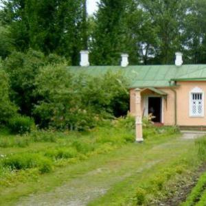
Coast of the Strait of La Mans (English Channel)
Despite the fact that the project of the tunnel was insanely costly, and to this day, all expenses still could not pay off, this building is still a model of modern engineering skills, which equally highly takes into account functionality and security.
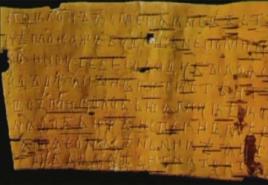
»In II B, BC e. Ancient Greek scholar Herodotus called this water alone "Oceanus Britannicus".
An interesting situation has developed around the name "La Mans". The French version was known from the XVII century. And means "sleeve". The Spaniards called the Strait of El Canal de la Mancha, the Portuguese canal darent mancha, the Italians of La Manica, Germans Ermeelkanal.
The desire of each of the peoples to convert the name to his own way was the persistent desire to present ownership of these unstable, but significant waters. Control over the strait gave enormous advantages. First, it was the closest way to England, and secondly, the shortest path in. Despite the initial nature of La Mans - frequent fogs, hurricane wind, high tides and insidious trends, - political and commercial importance outweigh all natural obstacles.
According to the most approximate calculations, the remains of several million people and tens of thousands of ships are resting at the bottom of the Strait: from the Roman Galer to diesel submarines. Such is the price of a centuries-old battle for the strait.
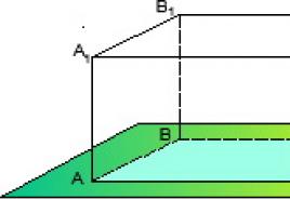
Nothing of this would have happened if the British Islands remained part of continental Europe 10 thousand years ago, during the last glaciation (Pleistoce). But the sushi in these places lay 120 m below the sea level, and as the glaciers melted the water filled the nisin, forming what we now call the strait of La Mans.
In peaceful times, the strait served a noble goal: he was a kind of water bridge, which was the cultural exchange between the Celts and the peoples of internal Europe, contributing to the formation of new languages \u200b\u200band nationalities. This indicates the obvious similarity of many dialects and customs common on both sides of the Strait.
However, in difficult times, the Strait has become a natural barrier on the path of conquerors, although not for everyone. They managed to successfully cross the strait and conquer British ancient Romans in I B. n. e., Normans in 1066, Wilhelm III Orange in 1688
Starting with Elizabeth I (1533-1603), the policy of the British kings in the area of \u200b\u200bthe Strait coincided with the invasion of England from the continent. For this, the British have ensured that none of the main European powers control the important ports on the other side of the strait. The formation of the British Empire would be impossible if the British did not establish the most severe control over the strait of La Mans.
The takeoff of England as the "Queen of the Seas" began after 1588, when the Spanish "invincible Armada" died from her shores, partly in the Strait of La Mans, where it was covered by one of the cruel la-mansh storms. On the occasion of the victory of Queen Elizabeth III commanded to emphasize the medal with the Latin inscription ADFLAVIT DEUS ET DISSIPATI SUNT ("God blew and they scattered").
France tried to conquer England twice twice: during the seven-year war (1756-63) and in the period of Napoleonic wars (1800-15). Both times "guests from the continent" collected a huge fleet, but never invaded the island. A considerable role was played here all the same famous la-manshest winds and storms, as they called the French, who started in the most favorable day for the invasion.
The first Lord of the British Admiralty Fisher said shortly before the beginning of the First World War: "Five keys hold the world on the castle: Singapore, Cape Town, Alexandria, Gibraltar and Duvr." The value of the La Mansian port of DUVR remained defining for the defense of the Strait.
On July 25, 1909, the Frenchman Louis Blerio first crossed La Mans on his monoplane, starting in Kale and landed in Dover. The British clearly made it clear that La Mans was no longer an insurmountable obstacle for the enemy's troops. In addition, Germany began to hastily build submarines, which was even greater threat to England. The British had to fight on land on land to get to the German submarine bases, but only in 1918, when the war was nearing completion, the threat of invasion of England from under the water was completely eliminated during the famous "Raid Zeebrughea" and the full marine blockade of Germany .
During World War II, the Theater of Military Action on the sea moved to the Atlantic, as the small waters and the narrow bays of La Mans were too dangerous for large-tonnant ships. Refusing direct invasion (Operation "Sea Lion"), German troops focused on the underwater war, the installation of minefields and rocket-artillery shelling of England through the strait.
In May 1940, the British Expeditionary Corps who fought on the side of France, together with the residues of the French army, retreated through Dunkirk under the onslaught of the advancing German army. It was the most ambitious rescue operation in the history of wars: 338 thousand soldiers were evacuated during the operation of the Dainemao operation.
During 1940-1945, the Germans built the most powerful fortifications on the continental side of the strait, called the Atlantic Shaft. Many have survived to this day, becoming tourist attractions. German troops managed to take several islands in the strait, but they did not advance further. Atlantic shaft fell in 1944, during the opening of the second front and the implementation of the Overlord operation on landing allied troops in Normandy.
After the end of the war, and with the beginning of the association of Europe, the issue of transport communication of the British islands with the continent was acute. Ferry crossings are outdated morally and technologically and did not cope with the carriage of goods, cars and railway cars. About 3.5 million people lived on the shores of La Mans., Surely needed in modern crossing.
The idea of \u200b\u200bbuilding a tunnel under La Mansha has a long history. Back in 1802, French Engineer Albert Mathieu-favie suggested a project of a tunnel for trips to Karet with the light of oil lamps. There were other projects, and even construction began: twice in 1876 and 1922, but both times the construction was frozen for political reasons.
The new project was launched in 1973 the underground crossing was opened in 1994 and received the name Eurotonnel. This is a two-way railway with a length of about 51 km (39 km under La Manshas). Thanks to the tunnel, you can now get from Paris to London in 2 hours 15 minutes; In the tunnel of the trains are 20-35 minutes.

general information
La Mans together with Pa de Calad connects the North Sea with the Atlantic Ocean
Major ports:
Great Britain - Portsmouth, Southampton, DUVR; France - Gavre, Kale, Cherbourg, Dunkirk, Diepp, Boulogne-sur-Mer.
The largest islands: White Island (United Kingdom), (Jersey and Guernsey), under the jurisdiction of Great Britain, off the coast of France.
Peninsula: Cornwall (United Kingdom), Cotanen (France).
Rivers flowing into the Strait: Sena, Somme, Orna, Vira (France); Ex, Dort, Tamer, Fal (United Kingdom).
Languages: English, French, Dialects of the Population of the Coast of the Strait (Gallo, Britten, Hat Canal, Ermel Channel, etc.).
Cash units: pound sterling, euro.
Numbers
Area: 75 000 km 2.
Length: 560 km.
Width: from 34 km (between the city of Dover, United Kingdom, and the city of Kale, France) to 240 km (between about. Mont-Saint-Michel, France, and County Devon, United Kingdom).
Medium depth on the widest site: 120 m.
The middle depth on the narrowest area: 45 m.
Minimum depth on the fairway: 23.5 m.
Maximum depth on the fairway: 172 m (Underwater Nizina Herp Dip).
Average flow rate: 12-13 km / h near the city of Portland. United Kingdom, 15-18.5 km / h at Cape Ag France.
Maximum height of tidal wave: 15 m (Saint-little city, France).
Average salinity: Over 35% °.
Economy
Shipping.
Minerals: Construction sand and gravel.
Fisheries: Turbo (Haltus), Kambala, Skat, Macrel, Merlan, Sea Eel (Congre). Breeding oysters.
Services sector:
tourism, transport.
Climate and weather
Moderate sea, significant impact of the Atlantic Ocean.
Average temperature: In winter + 4 ° C, in summer + 18 ° C.
The average temperature of the surface layer of water: January: + 6 ° C; July: + 19 ° C.
The average annual precipitation: 830 mm.
Mid annual cloudy: 7 points.
The average number of days a year with fogs: In the West - 34, in the East - 101. Storms in the fall and winter.
Relative humidity: 85-100%.
sights
■ Eurotonnel (France - United Kingdom);
■ Cretaceous reefs "Seven Sisters" (United Kingdom);
■ place of landing of the landing of allies (Normandy, France);
■ Guernsey Island (Norman Islands, United Kingdom): Cornet Castle (1206-1256), Victoria Tower (1848), Forts, Little Chapel, Mills;
■ The ruins of the Atlantic Shaft (France);
■ Cotanne Peninsula: Cherbourg City, Cape Flemanville (France);
■ Bertan Peninsula Lighthouses (France);
■ Rocks "Needles" (about. United Kingdom).
Curious facts
■ Herpz Dip - Wpadina at the bottom of La Mans - was used by the British during the First World War for the burial of chemical weapons. After the Second World War, German weapons were flooded here. Such operations continued until 1974 in the period 194673. Wpadin was used to flood radioactive waste.
■ Eurostar's trains move on Eurotonneel at a speed of 160 km / h.
■ Norman Islands as part of two coronal possessions Jersey and Guernsey are under the jurisdiction of the British monarchy, but are not part of the UK and are not part of the EU, although they are part of the customs territory of the EU.
■ On the island of Sark (Norman Islands) until 2008, a feudal control system was maintained - the latter in Europe. The island was ruled by the Council of Elders.
■ Giant sea eel, or a crucier, living in La Manne, reaches 3 m and weighs more than 100 kg.
■ On the island of Alderney (Norman Islands), the only railway on the islands is valid. Built in 1847, 3 km long, it works only in summer, on weekends and festive days.
■ The first in the history of mankind, the Strait of La Mans overpowered by the British swimmer Matthew Webb in 1875 in 21 h. 45 min. The slowest swim through the strait is 28 h. 44 min. (Jackie Kobell, United Kingdom, 2010)
It takes only 2 hours 15 minutes.
Predictable fate
The history of the development of the Para de Kale and its shores determined the geographical position - between the two regions of Western Europe and subsequently two countries.
He is now wearing two names, like La Mans, he, so to speak, the progenitor. La Mans for the British - English Channel, and most often just a channel, but in the language tradition of most European countries, French names were established: La Mans and Pa de Cala. Characteristic as in antiquity, I in. BC er, the Romans, the first to bring civilization to the shores on both sides of the Strait, called it British (if they were on the island of the United Kingdom) or Gallesky (if they were on the lands of Galov).
The geological history of the strait is relatively young. It was formed as a result of the flooding of an extensive territory, which included the Thames and Rhine delta. The hypothesis about that, as a result, the lowering of the sushi and the formation of the Strait took place, the modern interpretation found quite recently, in the first decade of our already century - thanks to the latest speaker devices with high resolution, hydrographic data obtained from ships equipped with GPS system. And it was found that the relief of the Pa de Calea has such characteristic features that appear on earthly solid after extensive floods associated with the melting of glaciers. Approximately 425 thousand years ago, a chalk ridge was held between the current dudes and feces, which served as a kind of dam between the sea and an array of the glacier. Gradually, the northeast of Dover melting floes formed a lake. Once it was overflowed, and a powerful stream, passing through the ridges of the chalk rocks, bold the ridge, and then his debris, chalk - the most loose and crumbly limestone structure. After 200 thousand years, during one of the relatively short-term glaciation, this natural cataclysm was repeated, spreading to the southwest, and the flood was even stronger than the first. But drying under the conditional name Doggerland, on the theory, nominated in the 1990s by British scientists, existed another 8 thousand years ago. This theory is hypothetical, but extremely logical and has recently been supported by new studies. So, on it, this sushi was a tundra inhabitable by people. The basis for such assumptions and the very name of Doggerland gave the discovery of a careful study of the sandy dogger bank, in the bottom sediments of which prehistoric tools of hunting were found. In Doggerland, also connected the ancient delta Thames and Rhine. As a result of the melting of glaciers, Doggerland gradually went under water. The final branch of British stones from the rest of Europe, and this is no longer a hypothesis, occurred about 6.5-6.2 thousand years ago. The resulting strait had borders, approximately coinciding with the current. Is that the distance from the mainland to the islands was even less.
It is impossible to say for sure when people began to swim, or, as sailors say, "walk", through the strait of Pa de Calais. Probably, at the same time, when they generally sat down in a boat or rafts. It is difficult to imagine that they could keep them from travel when they saw on a clear day from the place where the city of Kale, white rocks on the horizon are now. At the end of the prehistoric period, the territory of the British islands inhabited mainly Celtic tribes. Julia Caesar's soldiers, landed in 43, where the Dover's fortress was laid, they were close to earth facilities, spent in the rocks, and circles from stones laid out by Druid Belgiums, and White were one of the Gallean tribes. It is characteristic that such megalithic buildings were located in this part of Britain, on the shore. It means that the message through the shed between the Britti Celts and Celts-Gallam existed at least from the I millennium BC. e. The French city of Kale rose from the fishing village, and she, in turn, at the site of the settlement of the Stone Age. And today, fishing is one of the main classes of residents of the villages on both sides of the Strait. Tarbet (Falus), Kambala, Skat, Macrel (Mackerel), Doll Becpeger, Merlan and herring, octopuses and lobs are found in Pa-de-Kale. Oysters are collected on fellows, the truth is the best varieties (in the gastronomic sense) are found in other regions of La Mans, mainly in Normandy. The abundance of fauna is the best indicator of the environmental situation in the sea. And judging by the fact that with extremely intense shipping traffic in the strait, fishermen do not remain without work, joint environmental control of England and France with the support of the European Union are very effective.
■ About landing allies Feldmarshal Rommel found out only three hours after it began: on the eve he went to Berlin on personal matters. He summed up the "fox desert", as the Rommel called for cunning operations in North Africa, his praised intuition, which was kept in blind self-confidence, his intelligencely worked out of the hands.
■ Dover's castle, due to its strategic position with antiquity called "key to England," - one of the largest castles of England, built on the site of another Roman fortifications, towers over the sea at 114 m. It keeps a lot of legends, including related With the kings and queens, who had been living and for a long time. The castle is also famous for its tunnels, breakthroughs in the chalk cliffs at a depth of 15 m during the time of Napoleonic wars. The total length of them leaves about 6.3 km. The tunnels became the barracks, in 1803 they were accounted for up to 2000 soldiers. In addition, the hospital was equipped. In 1826, the tunnels were abandoned, during World War II served a bomb shelter, command item and a hospital again.
■ In 1580, an earthquake occurred off the shores of Dover, accompanied by the destruction of urban walls and tsunami. All the chronicles of England, France and Flanders XVI centuries report this earthquake. It is mentioned in the tragedy of V. Shakespeare "Romeo and Juliet" the mouth of the Kormilitsa Juliet. Most likely, the author himself survived him. During the construction of Eurotonnel, special studies were conducted and it was found that the earthquake of 1580 was valid to 5.9 points.
■ Heated Dress Kate Middleton, married to the English Prince William in 2011, was sewn from the machine lace created in Kale, a recognized center for the production of this exquisite material. Among the floral ornaments on the dress were crawled symbols of Great Britain - rose, thistle, daffodil and clover.
ATTRACTIONS
■ G. Kale: Watchtower (XIII century) on weapon area. Cathedral Notre Dame de Kale (Gothic, XIII century), Tower - XIV-XV centuries, Citadel (XVI century); City Hall (1911-1926). It is an accurate copy of the building in the style of the Flemish Renaissance demolished in 1818. Tower-Beffrua (Vechevaya Tower) of the City Hall - UNESCO World Heritage Site among other Beffrua France and Belgium; Sculpture O. Roden "Citizens Kale" (1895), International Center for Lace and Fashion; Museum-Manufactory of Lace.
■ G. Boulogne-sur-Mer: Beffru Tower (XI century), part of UNESCO World Heritage Site; Count Counts of Boulogne (XII-XIII century), fortress walls of the upper city (XIII century), the Cathedral of Notre Dame de Boulon (XIX century), built on the site of the destroyed Gothic Cathedral, the crypt contains genuine elements of the Romanesque and Gothic architecture; Hotel Dzadrusen (neoclassicism, XVIII century); National Sea Study Center (Maritime Aquarium, Sea Fauna Exhibition and Exposition, telling about modern methods of the Sea Resource Management).
■ Mr. Dunkirk: Beffru Tower (XIII century) Church of St. Air (Gothic, XV century), City Hall (beginning of the 20th century), Museum of Fine Arts, Museum of Contemporary Art with Park Sculptures and Child-oriented Museum Portouar ( history of the city);
■ G. Dover: White Chalk Rocks, Dover Lighthouse and Castle (Fortress) Dover, laid about 50 g. BC. e. (In the castle, the buildings of the XI-XIII centuries are preserved., But its main part today is the reconstruction of the XX century); Connot-Park, Natural Reserve Coland, Museum of Dover, Embankment.
■ Ramsgit: Victorian architecture, maritime museum, royal harbor.
■ Folkstone: close to the city - Railway Museum (Technique of the 1930s).
Atlas. Whole world in your hands number 131
English Channel (Franz. La Manche, literally - sleeve)
English Channel (English English Channel), shed between the northern shore of Western Europe and about. Great Britain. Together with the Strait of Pa-de-Calais (Duvrian Strait) connects the North Sea with the Atlantic Ocean. Length about 520. km,width on Z. about 180 km, on V. - 32 km.Depth on the fairway 35 m, The greatest depth 172. m. Many shames, especially in the eastern part of the strait. Western winds cause a steady eastern flow at a speed of up to 3 km / h (in narrowness). Semi-rich tides, their value in separate places reaches 12.2 m. (Saint-little bay). Functors. It has an important transport value. Through the Strait, one of the largest freight turnover paths from the countries of the North and Baltic seas to the countries of North and South America, as well as in Africa, Asia and Australia. Main ports: Portsmouth, Southampton, Plymouth (United Kingdom). Gavre, Cherbourg (France). Fisheries developed (flounder, mackerel, cod, halibut). There is a project (1973) of the underwater tunnel through the Strait of Pa de Calais. Strait of the English Channel.
Great Soviet Encyclopedia. - M.: Soviet Encyclopedia. 1969-1978 .
Synonyms:Watch what is "La Mans" in other dictionaries:
Manche MANCHE Details Information Room 50 Region Lower Normandy ... Wikipedia
mans-a-Bott - Manche à Bottes. Wide postponed cuffs of narrow French justocardines 70 90s. 17th century Merzalova 2 427 ...
mans Agrea Cone - * Manche Après La Cognée. Quit started; Walk on your hand. Rezker. The British incommunication does not exclude patience, as in some nations of the continent, ready to be ready for the failure of La Manche Après La Cognée. A. Jonich Selitician King. ... ... Historical Dictionary of Gallicalism Russian Language
mans Podg - * Manche Pagode. Expanding Blank Sleeve. Figure 3 shows a plush Visite, which can be the colors of Peau de Loutre or black, with a beaner trim on a collar and sleeves, resembling the sore Manche Pagode. New 1885 7 Mosaic ... ... Historical Dictionary of Gallicalism Russian Language
This term has other values, see Mans (values). Manche Manche ... Wikipedia
Robert Norman Mans, Eng. Robert Norman Munsch, (born June 11, 1945 (19450611), Pittsburgh, Pennsylvania) Canadian Children's Writer of American Origin. Contents 1 Biography 2 Awards ... Wikipedia
- ... Wikipedia
- (Manche) Department in the north west of France, in a hilly terrain on the Cotanen Peninsula. Area 6.4 thousand km2. Population of 453 thousand people (1971). Administrative center city Saint Lo. Livestock area; Under the pastures are employed ... ... Great Soviet Encyclopedia
- (La M.) DPT. all in. Parts of France, along the shore of Prol. La M.: 6411 square meters. km, residents in 1901 were 491372. The main mountains. S. Lo (6500 live.); Sherburg more significant (42938 live.). Climate sea, humid, with even, relatively warm temperature. ... ... Encyclopedic Dictionary F.A. Brockhaus and I.A. Efron
Mans - (MAnche) MAnche, Department in the field of Lower Normandy in Zap. France; pl. 5938 sq. Km, 479640 people. (1990); Adm. Center - Jen Lo ... Countries of the world. Vocabulary
Coordinates: 50 ° 11'01 "p. sh. 0 ° 31'52 "s. d. / 50.183611 ° С. sh. 0.531111 ° C. d. ... Wikipedia
Books
- Bridges through La Mans. British literature 1900 - 2000s
- Bridges through La Mans. British literature 1900-2000, Ringold Natalia Igorevna. The book included rare materials related to the English literature of the twentieth century, - Interview with Iris Murdoch, John Falez, Martin Emis and Pierce by Paul Reed, as well as essays about famous ...