Eastern hemisphere political map. Geographic map
Lesson on the world around
"Studying the map of the hemispheres", Grade 2.
Lesson Objectives:
1. Introduce the concepts of "part of the world", "continent", "ocean".
2. To teach to recognize "by sight" and find on the map of the hemispheres all parts of the world, continents and oceans.
4. Enrichment of the vocabulary of schoolchildren.
Equipment: globe, map of the hemispheres, a set of multimedia equipment, envelopes with tasks.
Software: Microsoftpowerpoint.
During the classes.
1. Good afternoon We begin the lesson of the world around. Today we have to study an important and interesting topic. This can be done in two ways:
And you can go on a journey, gaining new knowledge.
Raise your hand those who choose the first path. (…) And now those who are second. (…)Decided! Let's go on a trip! And we have a long journey ahead of us, there is a lot to see. So I suggest you take a trip.by plane . (slide).
Well, there is transport! What should a smart traveler take with them? (map). It is true that any journey is simply unthinkable without a map. And even more so in our case. Ask why? And everything is simple, we go on a trip exactly according to the map -on the map of the hemispheres. (slide) . Therefore, the theme of the lessonWe study the map of the hemispheres.
Let's remember what a map is? (Map - reduced image of the earth's surface on a plane).
What have we learned to distinguish on the map of the hemispheres? (Reservoirs in blue, plains in green and yellow, mountains in brown.)
3. Guys, what do you think, have people always known that the earth's surface looks like this? (No). It turns out that ancient people explored the earth gradually,in parts. They opened Parts of the world are large historical regions of the Earth, bounded by seas and mountains.
That part of the world where our ancestors lived a long time ago, they calledEUROPE . (slide)
Going south one day, brave ancient travelers discovered the existence of a third part of the world– AFRICA. (slide).
Much later, and quite by accident, the fourth part of the world was discovered -AMERICA. (slide).
The thirst for discoveries of ancient travelers made them surf the seas and oceans in search of new lands. And only after many years people discoveredAUSTRALIA with its amazing wildlife.(slide).
AND ANTARCTICA , that part of the world where permafrost reigned.(slide).
- Our ancestors began to divide the entire land of the Earth into such parts of the world. Let's repeat: Europe, Asia, Africa, America, Australia, Antarctica. (The teacher shows on the map, the children call parts of the world in unison.)
How many parts of the world are there? (6.) Quest from the Know-It-All: (slide).
“Pay attention, pictures appeared on our map of the hemispheres: a penguin, an Indian, a kangaroo, Mowgli with his friends, Misha and Lena, a giraffe. The know-it-all proposes to resettle their typical inhabitants in parts of the world.
Who could live in America part of the world? (Indian).
- Who could live in Antarctica?(penguin).
Who could live in Asia?(Mowgli).
- Who could live in Australia?(kangaroo).
Who could live in Africa?(giraffe).
Who could live in Europe?(Misha and Lena).
(During the children's answers, "inhabitants" in their part of the world appear on the screen.)
4. Do you know, guys, there is a more scientific division of the earth's land -on the continents - these are huge areas of land surrounded by water.
Look at the map of the hemispheres. How many continents, according to the definition, would you single out? (...). Let's check our assumptions. Our plane will land on every continent, and Know-It-All's helpers will tell us about it. So, first landing.
The largest continent on earthEurasia- ( slide). It takes a whole day to fly from one end to the other. It includes two parts of the world: Europe and Asia. The western part of the mainland - Europe - is a word of Greek origin and it means "west", and the eastern part of the mainland - Asia - means "east". The Ural Mountains are considered the border between Europe and Asia.
Mainland Africa coincides with part of the world Africa. Africa is the second largest continent in the world, second only to Eurasia in area. Almost all of Africa lies in a hot thermal zone, so it is the hottest continent on Earth.
part of the world America is divided into two continents, which are connected by the Isthmus of Panama. The continent north of the equator is calledNorth America , and the mainland, most of which is south of the equator, is namedSouth America.
Mainland Australia, located in the Eastern Hemisphere, also coincides with part of the world Australia. Australia is the smallest, flattest continent on Earth. And Australia is the driest continent, because the surrounding seas and oceans have little effect on the climate of the interior, so there is little rainfall.
The coldest continent on earthAntarctica , she is part of the world Antarctica. The entire mainland is covered with an ice sheet, and in some places mountain ranges with sharp ridges rise above it.
So, how many continents have we counted? (6). Let's call them again: Eurasia, Africa, North America, South America, Australia, Antarctica. (The teacher shows, the children call in chorus).
How amicably and confidently you named all the continents. Can you recognize these continents by their outlines?Quest from the Know-It-All is in box #1. Take out the contents of the envelope. (...) Here is a card with the contours of the continents, try to guess the familiar continents in these contours and sign them. (...) Exchange cards with a neighbor in your desk and check the correctness of the answers. (slide). Raise your hands who don't have a single mistake. Well done!
What continent is missing here? (Antarctica).
Guys, how many continents are there? (6). What about parts of the world? (also 6). Then why do they have different names? (Because the continent of Eurasia includes two parts of the world Europe and Asia, and part of the world America is divided into two continents South America and North America.)
Is there a difference between part of the world and the mainland? What is this difference? (If the children find it difficult to answer, you can remind them of the definitions of what is part of the world and what is the mainland.)
Fizkultminutka.
The sun is shining in a clear sky, (hands up, stretch)
The plane flies through the sky. (hands to the sides - we fly like a plane)
And at the bottom of the forest, fields - (tilt down)
The earth is spreading. (spreading arms to the sides).
5. Now I ask everyone to sit down, lie down with your head on the desk, close your eyes and listen. (The teacher turns on an audio recording with the sounds of sea waves).
What do these sounds remind you of? (Noise of water). That's right, our plane is flying over water. What is more water or land on the globe? (Chorus: water.) It turns out that all the water on the globe is also divided and has its own names. Large bodies of water between continents are calledoceans. Let's find the name of each ocean. Open the textbook on page 128 - 129, in front of you is a map of the hemispheres. I will talk about the location of each ocean, and when you find it, read its name.
This ocean washes the shores of America, Asia, Australia and Antarctica.( Pacific Ocean).
Name the body of water between America, Europe, Africa and Antarctica. (Atlantic Ocean ).
This ocean is located between Asia, Africa, Australia and Antarctica. (Indian Ocean ).
The ocean that washes Eurasia and North America is forever covered with ice.( Arctic Ocean).
“Our Earth has four oceans:
Indian - the most salty in the world,
The Atlantic Ocean is famous for herrings.
The Arctic sleeps under the ice,
And Quiet, of course, is not quiet at all,
And violent, deep and the greatest!
6. What a wonderful trip we have had! Is it true? But how attentive and observant you were, check the test from the Know-It-All. This test is in envelope #2, please take it out. After reading the question carefully, you must choose the correct answer from the three proposed options and mark it with a “tick”.
What continent are the two parts of the world on?
America
Eurasia
Antarctica
What part of the world unites two continents?
- America
Eurasia
Africa
What oceans surround Africa?
Arctic Ocean
Indian Ocean
Pacific Ocean
Atlantic Ocean
What ocean is located between Asia, America and Australia?
Arctic Ocean
Indian Ocean
- Pacific Ocean
Atlantic Ocean (…)
Check the correctness of your answers (a slide with the correct answers appears).
7.- Raise your hands if you answered all the questions correctly. (...).
Who had some difficulty? (...).
And who could not answer the questions at all? (...).
I'm very happy! This means that our journey through the map of the hemispheres was not in vain. Let's name all the parts of the world that we discovered during the journey (...), and now all the continents (...). And over what oceans did our plane fly? (...) Our journey is over, but at home you can continue it with the textbook material and answer the Know-It-All question: “Find the highest place on land and the deepest place in the ocean on the map of the hemispheres, find out what they are called.
Thanks everyone! The lesson is over! Rest!
Some maps show separate relatively small territories, while others show entire continents or oceans. What is shown on the physical map of the hemispheres? What is its scale? And what information can be extracted from it? You will definitely find answers to all these questions in our article.
A few words about cards
Cartography was born at about the same time as writing. In ancient times, our ancestors drew primitive plans on the walls of caves and rocks, on which they indicated important features of the area in which they lived. The first map of the world, according to scientists, was created in Babylon about 3 thousand years ago.
Cartography flourished during the so-called Age of Discovery. Numerous travelers and navigators created hundreds of fairly detailed and interesting maps. All the information received during wanderings to distant and unknown lands was applied to them.
Despite the passage of time, the map did not become archaic and retained its significance to this day. In modern science, there is even a special research method - cartographic. Today, geographical maps are used in various sectors of the national economy - urban planning, territorial planning, agriculture, transport, meteorology, tourism, etc.
Maps are different: physical, economic, recreational, climatic, synoptic, geological, political, and many, many others. Physical maps show continents and oceans. You can also see hydrographic objects (rivers, seas, lakes), various forms and sometimes the largest cities on them.
Back in 150 BC, the ancient Greek scientist Crates of Mallus created the first three-dimensional model of the Earth - a globe. However, later it turned out that using this model in practice is not so convenient. You won’t take it on a long hiking expedition, and it definitely won’t fit in a travel backpack. Besides, when you look at the globe, you see only one half of it. This is also not always convenient.

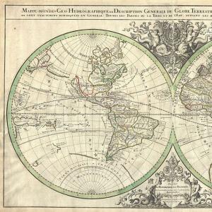
Apparently, this is why maps of the hemispheres of the Earth were invented. Of course, distortion is inevitable here. But on the other hand, such maps make it possible to contemplate the whole picture of the world at once, because they show two halves of our huge planet at once. If we dissect the globe along the equator, we will get a map of the Northern and Southern Hemispheres. If we divide the planet along the Zero (Greenwich) meridian, then we get, respectively, a map of the Western and Eastern hemispheres.
The scale of the physical map of the hemispheres
Scale is a purely mathematical concept. This is the ratio of the length of a segment on a geographical map or plan to the actual length of the same segment on the ground. For example, we have a topographic map with the following scale: 1:2000. This means that one centimeter on it corresponds to two thousand centimeters (or twenty meters) on the ground.
Physical maps of the hemispheres are of an overview nature and are used for educational purposes (usually in a wall version). Therefore, they tend to be small scale. The scales of physical maps of the hemispheres most often vary from 1:15,000,000 to 1:80,000,000. That is, the distance between Kiev and Moscow on them does not exceed 3-4 centimeters.
What is shown on the physical map of the hemispheres
On a physical map of any scale, various natural objects are displayed first of all. What exactly? What is shown on the physical map of the hemispheres of the Earth specifically? Let's list all these objects.
- Relief forms of hills, plateaus, mountain ranges).
- Elements of the coastline (islands, peninsulas, bays, straits, bays, capes).
- Hydrographic objects (seas, oceans, rivers, lakes, canals, large reservoirs, glaciers).
- Elements of the underwater relief (hollows, oceanic ridges, trenches).
- Capitals and largest cities.
The map of the Earth shows three continents (North and South America, Antarctica) and three oceans (Pacific, Atlantic and Arctic), on the map of the Eastern Hemisphere - four continents (Eurasia, Africa, Australia and Antarctica) and four oceans (Arctic, Atlantic , Pacific and Indian).

How to read a physical map
Any geographical map has its own specific language. Knowing this language, you can learn how to read it correctly. First of all, you should pay attention to the scale of the map. Most often it is placed in the upper left corner of the sheet. The scale is indicated not only in the numerical version, but also in the linear one, so that the process of determining distances on the map is as convenient as possible.
There are not too many symbols on the physical map of the hemispheres (as a rule, no more than two dozen). Thus, rivers are marked with dark blue lines, lakes and reservoirs are marked with blue spots. Continental ice and permanent snow are shown as rows of blue dots parallel to each other. This "pattern" covers most of Antarctica and Greenland.
On physical maps, you can also find some other conventional signs (see photo below). The relief on them is displayed using various shades. This is worth talking about in more detail below.

Relief display on a physical map
Under each physical map, the so-called scale of heights and depths with numerical marks in meters is necessarily placed. The forms of the earth's surface are indicated by different colors, depending on the absolute height of the area. Thus, lowlands are shown in green, uplands in yellow, mountain systems and ranges in orange or dark brown.

The same - and with depths. The shallow waters of the ocean floor are indicated by a light blue tint. But the deep areas are shown in more saturated blue. Here the principle is as follows: the deeper - the darker the color.
The absolute height marks of individual points on the land surface are indicated in black, and the depths of the seas and oceans are indicated in blue.
Physical map - a general geographical map that conveys the appearance of the territory and water area. It has, as a rule, a medium or small scale and is of an overview nature. The physical map shows in detail the relief and hydrography, as well as sands, glaciers, floating ice, nature reserves, mineral deposits; in less detail - socio-economic elements (settlements, communication routes, borders, etc.).
The knowledge we can gain from the map is great and useful. They will be useful to us in the future. This is the location of the continents and countries; rivers and lakes of the area; distance from the prime meridian; capital Cities; the height of mountain systems and ridges; the location of a particular geographical feature. We can get all this only by looking at the physical map of the world.
Physical map of the world

Physical map of Russia

The physical map of Russia gives a visual representation of the complex relief, different in origin, history of formation and external morphological features. It is distinguished by great contrasts: on the Russian and West Siberian plains, elevation changes amount to tens of meters, while in the mountains in the south and east of the country they reach hundreds of meters. In the north of the Russian Plain, the low mountain ranges of the Khibiny, Timan, and Pai-Khoi rise, and in the south, the plain passes into the Caspian and Azov lowlands, between which the foothills stretch, and then the mountain structures of the Caucasus.
The relatively low and flattened Ural Ridge. separates European Russia from the vast plains of the West. Siberia, which further to the east are replaced by the vast Central Siberian Plateau, and then the Far Eastern and Pacific mountain belts. In the south of Russia, there are systems of ridges and highlands, reaching heights of 3000-5000 m.
Physical map of Africa

Physical map of the hemispheres

Physical map of Europe

Physical map of Eurasia

Physical map of America

A whole world can fit on one sheet of the map, with all the oceans, continents, mountains and plains, countries, cities, minerals, animals and birds. You just need to be able to read the map correctly. In this lesson, we will learn what maps were in antiquity, and what types of maps are now, what are the advantages of a map over a globe, what is a scale, a map legend. We will learn how to use the scale of depths and heights, determine the coordinates of terrestrial objects.
Subject: The planet we live on
People started drawing maps even before they thought about whether the Earth is round or flat. Scientists have discovered in Kamchatka a drawing on a bone depicting a path to a place rich in prey. This is probably one of the oldest maps. Maps were drawn on pieces of bark, cut out on wooden boards, which were convenient to take on the road. Some peoples scratched cards with a sharp object on damp clay tiles, which, after drying, became strong, with a clear image.
This world map, in the center of which the city of Babylon is located, more than 3 thousand years.
Rice. 1. World map of Ancient Babylon ()
Rock paintings of the area were also found in caves where people lived thousands of years ago.

Rice. 2. Rock drawing of the area ()
With the invention of paper, cards began to be drawn on it. All the information received by scientists and travelers during their wanderings in different lands was applied to the maps.

Rice. 3. Ancient map of the world on paper ()
Making a map was a long process, because all the details were drawn by hand, so the cards were very expensive.
For a long period of time, only four were present on the maps: Eurasia, Africa, North America, South America. Many years passed before navigators discovered Australia and Antarctica.
When you look for any country on the globe, you see only one hemisphere. And to see something else, the globe must be rotated.

It is impossible to designate a large number of geographical objects on a globe without increasing its size. A large globe is inconvenient for travel use.
Scale- this is the ratio of the length of the lines on the map or drawing to the actual length. The scale of the physical map of Russia tells us that each centimeter of the map corresponds to 200 km on the ground.

Rice. 7. Physical map of Russia ()
On the map you can show two halves of the Earth at once. If you divide the globe along the equator, you get map of the northern and southern hemispheres,

Rice. 5. Northern and Southern Hemispheres
and if along the line of the zero meridian - Western and Eastern Hemispheres.

Rice. 6. Western and Eastern Hemispheres
On mineral map special icons mark the places of mineral deposits.

Rice. 9. Map of minerals ()
On animal habitat maps the habitats of various species of birds and animals are indicated.

Rice. 10. Bird and animal habitat map ()
On contour maps there are no color designations and depicted, but not signed, all kinds of geographical objects. They are convenient for laying routes.

Rice. 11. Contour map
On political map of the world depict countries and their borders.

Rice. 12. Political map of Eurasia ()
On synoptic maps conditional icons show observations of the weather.

Rice. 13. Synoptic map ()
Various cards are combined into atlases.

Rice. 14. Geographic atlas ()
The maps depict different territories. There are maps of districts, cities, regions, states, continents, oceans, maps of the hemispheres and world maps.
Conventions on the map are the same as on the globe. They're called legend and are usually placed at the bottom of the map.

Let's find the West Siberian Plain on the physical map of Russia.

Rice. 16. West Siberian Plain ()
Small horizontal lines covering a large part of its territory mean swamps.
Here are one of the largest swamps in the world - Vasyugan. The lines represent rivers, borders and roads, the circles represent cities.

Rice. 17. Vasyugan swamps
The seas and mountains have real outlines and are painted in different colors. Blue and light blue - reservoirs, yellow - hills, green - lowlands, brown - mountains.
At the bottom of the map, a scale of depths and heights is placed, with which you can see what height or depth means this or that shade of color on the map.
The deeper the ocean, the darker the color. On the map of the Arctic Ocean, the darkest shade of blue is in the Greenland Sea, where the depth reaches 5,527 meters; the lightest shade of pale blue, where the depth of the sea is 200 meters.

Rice. 18. Physical map of the Arctic Ocean
The higher the mountains, the darker the color they are marked with. Thus, the Ural Mountains, which are considered relatively low (the highest peaks from 1000 to 2000 m above sea level), are colored light brown on the map.

Rice. 19. Ural Mountains
Himalayas - the highest mountains in the world (10 peaks with a height of more than 8 km) are indicated in dark brown.

Rice. 20. Himalayan mountains

In the Himalayas is located Chomolungma (Everest) - the highest peak in the world (8848 m).

Using the height scale, it is easy to determine the height of the Caucasus Mountains.

Rice. 23. Caucasus Mountains
Their brown color indicates that the height of the mountains is more than 5 thousand meters. The most famous peaks - Mount Elbrus (5642 m) and Mount Kazbek (5033 m) are covered with eternal snow and glaciers.


Using the map, you can determine the exact location of any object. To do this, you need to know coordinates: latitude and longitude, which are determined by the degree grid formed by parallels and meridians.

Rice. 26. Degree grid
The equator serves as a reference point - on it the latitude is 0⁰. Latitude is measured from 0⁰ to 90⁰ on either side of the equator and is called north or south. For example, the coordinate 60⁰ North means that this point lies in the Northern Hemisphere and is at an angle of 60⁰ to the equator.

Rice. 27. Latitude
Longitude is measured from 0⁰ to 180⁰ on both sides of the Greenwich meridian and is called western or eastern.

Rice. 28. Longitude
St. Petersburg coordinates - 60⁰ N, 30⁰ E
Moscow coordinates - 55⁰ N, 37⁰E

Rice. 29. Political map of Russia ()
- Vakhrushev A.A., Danilov D.D. The world around 3. M .: Ballas.
- Dmitrieva N.Ya., Kazakov A.N. The world around 3. M .: Publishing house "Fedorov".
- Pleshakov A.A. Surrounding world 3. M .: Enlightenment.
- Academician ().
- survival().
- Locate the Pacific Ocean on the physical map of the world. Determine its deepest place, indicate its name and depth. Describe how you identified this place.
- Make a short test (4 questions with three answers) on the topic "Geographic maps".
- Prepare a memo with the rules for working with cards.