Provincial district city of the Russian Empire of the 19th – early 20th centuries: based on materials from the Vyatka province. Administrative-territorial division of the Russian Empire Provinces of the 19th century
First provinces appeared in Russia at the beginning of the 18th century. December 18, 1708 Peter I signed a Decree on dividing the country into provinces: “The Great Sovereign indicated... for the benefit of the whole people, to create provinces and add cities to them.” From this time on, these highest units of administrative division and local government in Russia began to exist.
The immediate reason for the reform of 1708 was the need to change the system of financing and food and material support for the army (land regiments, fortress garrisons, artillery and navy were “assigned” to provinces and received money and provisions through special commissars). Initially there were 8 provinces, then their number increased to 23.
In 1775 Catherine II a reform of provincial government was carried out. In the preface " Institutions for governing the provinces of the All-Russian Empire" the following was noted: "... due to the great vastness of some provinces, they are not sufficiently equipped, both with governments and with the people needed to govern...." The new division into the province was based on a statistical principle - the number of the population of the province was limited to 300 - 400 thousand revision souls (20 - 30 thousand per county). As a result, instead of 23 provinces, 50 were created." Establishment"provided for the sectoral construction of local bodies, the creation locally of an extensive network of administrative-police, judicial and financial-economic institutions, which were subject to general supervision and management by the heads of local administration. Almost all local institutions had a "common presence" - a collegial body in which several officials (councilors and assessors) sat. Among these institutions were: the provincial board, in which sat the governor-general (or “viceroy”), the governor (this position was retained, but sometimes he was called the “governor of the governorship”) and two councilors; chamber (the main financial and economic body, which was headed by the vice-governor or, as he was sometimes called, “the lieutenant of the ruler”); criminal chamber; civil chamber; order of public charity (issues of education, health care, etc. were resolved here), and some others. The provinces with the new administrative apparatus were called governorships, although along with the term “government” the term “province” was retained in the legislation and office work of that time.
Governors, unlike former governors, had even broader powers and greater independence. They could be present in the Senate with the right to vote on an equal basis with senators. Their rights were limited only by the Empress and the Council at the Imperial Court. The governors and their apparatus were not at all subordinate to the collegiums. The dismissal and appointment of local officials (except for the ranks of the viceroyal government and prosecutorial ranks) depended on their will. " Establishment"gave the governor-general not only enormous power, but also honor: he had an escort, adjutants and, in addition, a personal retinue consisting of young nobles of the province (one from each district). Often the power of the governor-general extended to several governorships At the end of the 18th century, the positions of governors (governors general) and the governorships themselves were abolished, and the leadership of the provinces was again concentrated in the hands of governors.
The provisional government, which came to power in early March 1917, retained the entire system of provincial institutions, only the governors were replaced by provincial commissars. But in parallel, the Soviet system had already arisen and existed. The October Revolution preserved the division into provinces, but eliminated the entire old provincial apparatus. The division into provinces finally disappeared in the 30s of the 20th century.
At the beginning of the 19th century. The borders of Russian possessions in North America and northern Europe were officially consolidated. The St. Petersburg Conventions of 1824 determined the boundaries with American () and English possessions. The Americans pledged not to settle north of 54°40" N on the coast, and the Russians - to the south. The border of Russian and British possessions ran along the coast from 54° N to 60° N at a distance of 10 miles from the ocean's edge , taking into account all the bends of the coast.The St. Petersburg Russian-Swedish Convention of 1826 established the Russian-Norwegian border.
Academic expeditions of V. M. Severgin and A. I. Sherer in 1802-1804. to the north-west of Russia, Belarus, the Baltic states and were devoted mainly to mineralogical research.
The period of geographical discoveries in the populated European part of Russia is over. In the 19th century expeditionary research and its scientific synthesis were mainly thematic. Of these, we can name the zoning (mainly agricultural) of European Russia into eight latitudinal stripes, proposed by E. F. Kankrin in 1834; botanical and geographical zoning of European Russia by R. E. Trautfetter (1851); studies of the natural conditions of the Caspian Sea, the state of fishing and other industries there (1851-1857), carried out by K. M. Baer; N.A.’s work (1855) on the fauna of the Voronezh province, in which he showed deep connections between the fauna and physical-geographical conditions, and also established patterns of distribution of forests and steppes in connection with the nature of the relief and soils; classical soil studies of V.V. in the zone, begun in 1877; a special expedition led by V.V. Dokuchaev, organized by the Forestry Department to comprehensively study the nature of the steppes and find ways to combat. In this expedition, a stationary research method was used for the first time.
Caucasus
The annexation of the Caucasus to Russia necessitated the study of new Russian lands, the knowledge of which was poor. In 1829, the Caucasian expedition of the Academy of Sciences, led by A. Ya. Kupfer and E. X. Lenz, explored the Rocky Range in the Greater Caucasus system and determined the exact heights of many mountain peaks of the Caucasus. In 1844-1865 The natural conditions of the Caucasus were studied by G.V. Abikh. He studied in detail the orography and geology of the Greater and Dagestan, the Colchis Lowland, and compiled the first general orographic diagram of the Caucasus.
Ural
Among the works that developed the geographical understanding of the Urals are the description of the Middle and Southern Urals, made in 1825-1836. A. Ya. Kupfer, E. K. Hoffman, G. P. Gelmersen; publication of “Natural History of the Orenburg Region” by E. A. Eversman (1840), which provides a comprehensive description of the nature of this territory with a well-founded natural division; expedition of the Russian Geographical Society to the Northern and Polar Urals (E.K. Goffman, V.G. Bragin), during which the peak of Konstantinov Kamen was discovered, the Pai-Khoi ridge was discovered and explored, an inventory was compiled, which served as the basis for drawing up a map of the explored part of the Urals . A notable event was the journey in 1829 of the outstanding German naturalist A. Humboldt to the Urals, Rudny Altai and the shores of the Caspian Sea.
Siberia
In the 19th century Research continued in Siberia, many areas of which were very poorly studied. In Altai in the 1st half of the century the sources of the river were discovered. Katun, explored (1825-1836, A. A. Bunge, F. V. Gebler), the Chulyshman and Abakan rivers (1840-1845, P. A. Chikhachev). During his travels, P. A. Chikhachev carried out physical, geographical and geological research.
In 1843-1844. A.F. Middendorf collected extensive material on orography, geology, climate, and the organic world of Eastern Siberia and the Far East; for the first time, information was obtained about the nature of Taimyr and the Stanovoy Range. Based on the travel materials, A. F. Middendorf wrote in 1860-1878. published “Journey to the North and East of Siberia” - one of the best examples of systematic reports on the nature of the explored territories. This work provides characteristics of all the main natural components, as well as the population, shows the relief features of Central Siberia, the uniqueness of its climate, presents the results of the first scientific study of permafrost, and gives the zoogeographic division of Siberia.
In 1853-1855. R. K. Maak and A. K. Sondgagen investigated the geology and life of the population of the Central Yakut Plain, the Central Siberian Plateau, the Vilyui Plateau, and surveyed the river.
In 1855-1862. The Siberian expedition of the Russian Geographical Society carried out topographic surveys, astronomical determinations, geological and other studies in the south of Eastern Siberia.
A large amount of research was carried out in the second half of the century in the mountains of southern Eastern Siberia. In 1858, geographical research in the Sayan Mountains was carried out by L. E. Schwartz. During them, topographer Kryzhin carried out a topographic survey. In 1863-1866. research in Eastern Siberia and the Far East was carried out by P. A. Kropotkin, who paid special attention to relief and. He explored the Oka, Amur, Ussuri rivers, ridges, and discovered the Patom Highlands. The Khamar-Daban ridge, coastline, Angara region, Selenga basin, were explored by A. L. Chekanovsky (1869-1875), I. D. Chersky (1872-1882). In addition, A. L. Chekanovsky explored the basins of the Lower Tunguska and Olenyok rivers, and I. D. Chersky explored the upper reaches of the Lower Tunguska. A geographical, geological and botanical survey of the Eastern Sayan was carried out during the Sayan expedition by N.P. Bobyr, L.A. Yachevsky, and Ya.P. Prein. The study of Sayanskaya in 1903 was continued by V.L. Popov. In 1910, he also carried out a geographical study of the border strip between Russia and China from Altai to Kyakhta.
In 1891-1892 During his last expedition, I. D. Chersky explored the Nerskoye Plateau and discovered three high mountain ranges behind the Verkhoyansk Range: Tas-Kystabyt, Ulakhan-Chistai and Tomuskhai.

Far East
Research continued on Sakhalin, the Kuril Islands and the adjacent seas. In 1805, I. F. Kruzenshtern explored the eastern and northern shores of Sakhalin and the northern Kuril Islands, and in 1811, V. M. Golovnin made an inventory of the middle and southern parts of the Kuril ridge. In 1849, G.I. Nevelskoy confirmed and proved the navigability of the Amur mouth for large ships. In 1850-1853. G.I. Nevelsky and others continued their research on Sakhalin and adjacent parts of the mainland. In 1860-1867 Sakhalin was explored by F.B., P.P. Glen, G.W. Shebunin. In 1852-1853 N. K Boshnyak explored and described the basins of the Amgun and Tym rivers, lakes Everon and Chukchagirskoe, the Bureinsky ridge, and Khadzhi Bay (Sovetskaya Gavan).
In 1842-1845. A.F. Middendorf and V.V. Vaganov explored the Shantar Islands.
In the 50-60s. XIX century The coastal parts of Primorye were explored: in 1853 -1855. I. S. Unkovsky discovered the bays of Posyet and Olga; in 1860-1867 V. Babkin surveyed the northern shore of the Sea of Japan and Peter the Great Bay. The Lower Amur and the northern part of Sikhote-Alin were explored in 1850-1853. G. I. Nevelsky, N. K. Boshnyak, D. I. Orlov and others; in 1860-1867 - A. Budishchev. In 1858, M. Venyukov explored the Ussuri River. In 1863-1866. and Ussuri were studied by P.A. Kropotkin. In 1867-1869 made a major trip around the Ussuri region. He conducted comprehensive studies of the nature of the Ussuri and Suchan river basins and crossed the Sikhote-Alin ridge.
middle Asia
As individual parts of Central Asia annexed to the Russian Empire, and sometimes even preceding it, Russian geographers, biologists and other scientists explored and studied their nature. In 1820-1836. the organic world of Mugodzhar, General Syrt and the Ustyurt plateau was explored by E. A. Eversman. In 1825-1836 carried out a description of the eastern coast of the Caspian Sea, the Mangystau and Bolshoi Balkhan ridges, the Krasnovodsk plateau G. S. Karelin and I. Blaramberg. In 1837-1842. A.I. Shrenk studied Eastern Kazakhstan.
In 1840-1845. The Balkhash-Alakol basin was discovered (A.I. Shrenk, T.F. Nifantiev). From 1852 to 1863 T.F. Nifantiev carried out the first surveys of lakes, Zaysan. In 1848-1849 A.I. Butakov carried out the first survey, a number of islands and Chernyshev Bay were discovered.
Valuable scientific results, especially in the field of biogeography, were brought by the 1857 expedition of I. G. Borschov and N. A. Severtsov to Mugodzhary, the Emba River basin and the Big Barsuki sands. In 1865, I. G. Borshchov continued research on the vegetation and natural conditions of the Aral-Caspian region. He considered steppes and deserts as natural geographical complexes and analyzed the mutual relationships between relief, moisture, soils and vegetation.
Since the 1840s exploration of the highlands of Central Asia began. In 1840-1845. A.A. Leman and Ya.P. Yakovlev discovered the Turkestan and Zeravshan ranges. In 1856-1857 P.P. Semenov laid the foundation for the scientific study of the Tien Shan. The heyday of research in the mountains of Central Asia occurred during the period of the expeditionary leadership of P. P. Semenov (Semyonov-Tyan-Shansky). In 1860-1867 N.A. Severtsov explored the Kirghiz and Karatau ridges, discovered the Karzhantau, Pskem and Kakshaal-Too ridges in 1868-1871. A.P. Fedchenko explored the Tien Shan, Kukhistan, Alai and Trans-Alai ranges. N.A. Severtsov, A.I. Scassi discovered the Rushansky ridge and the Fedchenko glacier (1877-1879). The research carried out made it possible to identify the Pamirs as a separate mountain system.
Research in the desert regions of Central Asia was carried out by N. A. Severtsov (1866-1868) and A. P. Fedchenko in 1868-1871. (Kyzylkum desert), V. A. Obruchev in 1886-1888. (Karakum desert and ancient Uzboy valley).
Comprehensive studies of the Aral Sea in 1899-1902. spent .
North and Arctic

At the beginning of the 19th century. The discovery of the New Siberian Islands ended. In 1800-1806. Y. Sannikov made an inventory of the islands of Stolbovoy, Faddeevsky, and New Siberia. In 1808, Belkov discovered an island, which received the name of its discoverer - Belkovsky. In 1809-1811 visited by the expedition of M. M. Gedenstrom. In 1815, M. Lyakhov discovered the islands of Vasilyevsky and Semyonovsky. In 1821-1823 P.F. Anjou and P.I. Ilyin carried out instrumental research, culminating in the compilation of an accurate map of the New Siberian Islands, explored and described the islands of Semenovsky, Vasilyevsky, Stolbovoy, the coast between the mouths of the Indigirka and Olenyok rivers, and discovered the East Siberian polynya.
In 1820-1824. F. P. Wrangel, in very difficult natural conditions, traveled through the north of Siberia and the Arctic Ocean, explored and described the coast from the mouth of the Indigirka to the Kolyuchinskaya Bay (Chukchi Peninsula), and predicted the existence.
Research was carried out in Russian possessions in North America: in 1816, O. E. Kotzebue discovered a large bay in the Chukchi Sea off the western coast of Alaska, named after him. In 1818-1819 The eastern coast of the Bering Sea was explored by P.G. Korsakovsky and P.A. Ustyugov, the Alaska-Yukon delta was discovered. In 1835-1838. The lower and middle reaches of the Yukon were studied by A. Glazunov and V.I. Malakhov, and in 1842-1843. - Russian naval officer L. A. Zagoskin. He also described the interior regions of Alaska. In 1829-1835 The coast of Alaska was explored by F.P. Wrangel and D.F. Zarembo. In 1838 A.F. Kashevarov described the northwestern coast of Alaska, and P.F. Kolmakov discovered the Innoko River and the Kuskokwim (Kuskokwim) ridge. In 1835-1841. D.F. Zarembo and P. Mitkov completed the discovery of the Alexander Archipelago.
The archipelago was intensively explored. In 1821-1824. F.P. Litke on the brig “Novaya Zemlya” explored, described and compiled a map of the western coast of Novaya Zemlya. Attempts to inventory and map the eastern coast of Novaya Zemlya were unsuccessful. In 1832-1833 The first inventory of the entire eastern coast of the South Island of Novaya Zemlya was made by P.K. Pakhtusov. In 1834-1835 P.K. Pakhtusov and in 1837-1838. A.K. Tsivolka and S.A. Moiseev described the eastern coast of the North Island up to 74.5° N. sh., the Matochkin Shar Strait is described in detail, Pakhtusov Island is discovered. A description of the northern part of Novaya Zemlya was made only in 1907-1911. V. A. Rusanov. Expeditions led by I. N. Ivanov in 1826-1829. managed to compile an inventory of the southwestern part of the Kara Sea from Nos to the mouth of the Ob. The research carried out made it possible to begin the study of vegetation, fauna and the geological structure of Novaya Zemlya (K. M. Baer, 1837). In 1834-1839, especially during a major expedition in 1837, A.I. Shrenk explored the Czech Bay, the coast of the Kara Sea, the Timan Ridge, the island, the Pai-Khoi ridge, and the polar Urals. Explorations of this area in 1840-1845. continued A.A. Keyserling, who conducted the survey and explored the Timan Ridge and the Pechora Lowland. He conducted comprehensive studies of the nature of the Taimyr Peninsula and the North Siberian Lowland in 1842-1845. A. F. Middendorf. In 1847-1850 The Russian Geographical Society organized an expedition to the Northern and Polar Urals, during which the Pai-Khoi ridge was thoroughly explored.
In 1867, Wrangel Island was discovered, an inventory of the southern coast of which was made by the captain of the American whaling ship T. Long. In 1881, the American researcher R. Berry described the eastern, western and most of the northern coast of the island, and the interior of the island was explored for the first time.

In 1901, the Russian icebreaker “ ”, under the command of S. O. Makarov, visited. In 1913-1914 A Russian expedition led by G. Ya. Sedov wintered on the archipelago. At the same time, a group of participants from G.L. Brusilov’s expedition in distress on the ship “St. Anna”, headed by navigator V.I. Albanov. Despite the difficult conditions, when all energy was aimed at preserving life, V.I. Albanov proved that Petermann Land and King Oscar Land, which appeared on the map of J. Payer, do not exist.
In 1878-1879 During two navigations, a Russian-Swedish expedition led by the Swedish scientist N.A.E. on the small sailing-steam vessel “Vega” was the first to navigate the Northern Sea Route from west to east. This proved the possibility of navigation along the entire Eurasian Arctic coast.
In 1913, the Northern Hydrographic Expedition under the leadership of B. A. Vilkitsky on the icebreaking steamships “Taimyr” and “Vaigach”, exploring the possibilities of passing the route north of Taimyr, encountered solid ice and, following their edge to the north, discovered islands called Zemlya Emperor Nicholas II (now Severnaya Zemlya), approximately mapping its eastern, and next year - southern shores, as well as the island of Tsarevich Alexei (now -). The western and northern shores remained completely unknown.
Russian Geographical Society
The Russian Geographical Society (RGS), founded in 1845, (since 1850 - the Imperial Russian Geographical Society - IRGO) has great merit in the development of domestic cartography.
In 1881, the American polar explorer J. DeLong discovered the islands of Jeannette, Henrietta and Bennett northeast of the island of New Siberia. This group of islands was named after its discoverer. In 1885-1886 A study of the Arctic coast between the Lena and Kolyma rivers and the New Siberian Islands was carried out by A. A. Bunge and E. V. Toll.
Already at the beginning of 1852, it published its first twenty-five-verst (1:1,050,000) map of the Pai-Khoi coastal ridge, compiled based on materials from the Ural Expedition of the Russian Geographical Society of 1847-1850. For the first time, the Pai Khoi coastal ridge was depicted with great accuracy and detail.
The Geographical Society also published 40-verst maps of the river areas of the Amur, the southern part of the Lena and Yenisei and about. Sakhalin on 7 sheets (1891).
Sixteen large expeditions of the IRGO, led by N. M. Przhevalsky, G. N. Potanin, M. V. Pevtsov, G. E. Grumm-Grzhimailo, V. I. Roborovsky, P. K. Kozlov and V. A. Obruchev, made a great contribution to the filming of Central Asia. During these expeditions, 95,473 km were covered and filmed (of which over 30,000 km were accounted for by N. M. Przhevalsky), 363 astronomical points were determined and the altitudes of 3,533 points were measured. The position of the main mountain ranges and river systems, as well as lake basins of Central Asia, was clarified. All this significantly contributed to the creation of a modern physical map of Central Asia.
The heyday of the expeditionary activities of the IRGO occurred in 1873-1914, when the head of the society was Grand Duke Constantine, and P.P. Semyonov-Tyan-Shansky was the vice-chairman. During this period, expeditions were organized to Central Asia and other regions of the country; two polar stations were created. Since the mid-1880s. The expeditionary activities of the society are increasingly specialized in certain fields - glaciology, limnology, geophysics, biogeography, etc.

IRGO made a great contribution to the study of the country's topography. To process the leveling and produce a hypsometric map, the IRGO hypsometric commission was created. In 1874, IRGO carried out, under the leadership of A. A. Tillo, the Aral-Caspian leveling: from Karatamak (on the northwestern shore of the Aral Sea) through Ustyurt to the Dead Kultuk Bay of the Caspian Sea, and in 1875 and 1877. Siberian leveling: from the village of Zverinogolovskaya in the Orenburg region to Lake Baikal. The materials of the hypsometric commission were used by A. A. Tillo to compile the “map of European Russia” on a scale of 60 versts per inch (1: 2,520,000), published by the Ministry of Railways in 1889. More than 50 thousand elevation marks were used to compile it , obtained as a result of leveling. The map revolutionized ideas about the structure of the relief of this territory. It presented in a new way the orography of the European part of the country, which has not changed in its main features to this day; the Central Russian and Volga uplands were depicted for the first time. In 1894, the Forestry Department, under the leadership of A. A. Tillo with the participation of S. N., organized an expedition to study the sources of the main rivers of European Russia, which provided extensive material on relief and hydrography (in particular, on lakes).
The military topographical service carried out, with the active participation of the Imperial Russian Geographical Society, a large number of pioneering reconnaissance surveys in the Far East, Siberia, Kazakhstan and Central Asia, during which maps were drawn up of many territories that had previously been “blank spots” on the map.
Mapping the territory in the 19th and early 20th centuries.
Topographic and geodetic works

In 1801-1804. “His Majesty’s Own Map Depot” released the first state multi-sheet (107 sheets) map at a scale of 1:840,000, covering almost all of European Russia and called the “Cental-sheet Map”. Its content was based mainly on materials from the General Survey.
In 1798-1804. The Russian General Staff, under the leadership of Major General F. F. Steinhel (Steingel), with the extensive use of Swedish-Finnish topographic officers, carried out a large-scale topographic survey of the so-called Old Finland, i.e., the areas annexed to Russia along the Nystadt (1721) and Abosky (1743) to the world. The survey materials, preserved in the form of a handwritten four-volume atlas, were widely used in the compilation of various maps at the beginning of the 19th century.
After 1809, the topographic services of Russia and Finland were united. At the same time, the Russian army received a ready-made educational institution for training professional topographers - a military school founded in 1779 in the village of Gappaniemi. On the basis of this school, on March 16, 1812, the Gappanyem Topographical Corps was established, which became the first special military topographic and geodetic educational institution in the Russian Empire.
In 1815, the ranks of the Russian army were replenished with topographical officers of the General Quartermaster of the Polish Army.
Since 1819, topographic surveys began in Russia on a scale of 1:21,000, based on triangulation and carried out mainly using scales. In 1844 they were replaced by surveys at a scale of 1:42,000.

On January 28, 1822, the Corps of Military Topographers was established at the General Headquarters of the Russian Army and the Military Topographic Depot. State topographic mapping became one of the main tasks of military topographers. The remarkable Russian surveyor and cartographer F. F. Schubert was appointed the first director of the Corps of Military Topographers.
In 1816-1852. In Russia, the largest triangulation work of that time was carried out, extending 25°20" along the meridian (together with Scandinavian triangulation).
Under the leadership of F. F. Schubert and K. I. Tenner, intensive instrumental and semi-instrumental (route) surveys began, mainly in the western and northwestern provinces of European Russia. Based on materials from these surveys in the 20-30s. XIX century semitopographic (semi-topographic) maps of the provinces were compiled and engraved on a scale of 4-5 versts per inch.
The military topographic depot began in 1821 to compile a survey topographic map of European Russia on a scale of 10 versts per inch (1:420,000), which was extremely necessary not only for the military, but also for all civilian departments. The special ten-verst map of European Russia is known in the literature as the Schubert Map. Work on creating the map continued intermittently until 1839. It was published on 59 sheets and three flaps (or half-sheets).
A large amount of work was carried out by the Corps of Military Topographers in different parts of the country. In 1826-1829 Detailed maps on a scale of 1:210,000 were compiled for the Baku province, the Talysh Khanate, the Karabakh province, the plan of Tiflis, etc.
In 1828-1832. A survey of Wallachia was also carried out, which became a model of work of its time, since it was based on a sufficient number of astronomical points. All maps were compiled into a 1:16,000 atlas. The total survey area reached 100 thousand square meters. verst.
Since the 30s. Geodetic and boundary work began to be carried out on. Geodetic points carried out in 1836-1838. triangulations became the basis for creating accurate topographic maps of Crimea. Geodetic networks developed in Smolensk, Moscow, Mogilev, Tver, Novgorod provinces and other areas.
In 1833, the head of the KVT, General F. F. Schubert, organized an unprecedented chronometric expedition in the Baltic Sea. As a result of the expedition, the longitudes of 18 points were determined, which, together with 22 points related to them trigonometrically, provided a reliable basis for surveying the coast and soundings of the Baltic Sea.

From 1857 to 1862 under the leadership and funds of the IRGO, work was carried out at the Military Topographical Depot to compile and publish on 12 sheets a general map of European Russia and the Caucasus region on a scale of 40 versts per inch (1: 1,680,000) with an explanatory note. On the advice of V. Ya. Struve, the map for the first time in Russia was created in the Gaussian projection, and Pulkovsky was taken as the prime meridian on it. In 1868, the map was published, and later it was reprinted several times.
In subsequent years, a five-verst map on 55 sheets, a twenty-verst map and an orographic forty-verst map of the Caucasus were published.
Among the best cartographic works of the IRGO is the “Map of the Aral Sea and the Khiva Khanate with their surroundings” compiled by Ya. V. Khanykov (1850). The map was published in French by the Paris Geographical Society and, on the proposal of A. Humboldt, was awarded the Prussian Order of the Red Eagle, 2nd degree.
The Caucasian military topographic department, under the leadership of General I. I. Stebnitsky, conducted reconnaissance in Central Asia along the eastern shore of the Caspian Sea.
In 1867, a Cartographic Establishment was opened at the Military Topographical Department of the General Staff. Together with the private cartographic establishment of A. A. Ilyin, opened in 1859, they were the direct predecessors of modern domestic cartographic factories.
A special place among the various products of the Caucasian WTO was occupied by relief maps. The large relief map was completed in 1868, and was exhibited at the Paris Exhibition in 1869. This map is made for horizontal distances on a scale of 1:420,000, and for vertical distances - 1:84,000.
The Caucasian military topographic department under the leadership of I. I. Stebnitsky compiled a 20-verst map of the Trans-Caspian region based on astronomical, geodetic and topographical work.

Work was also carried out on topographic and geodetic preparation of the territories of the Far East. Thus, in 1860, the position of eight points was determined near the western coast of the Sea of Japan, and in 1863, 22 points were determined in Peter the Great Bay.
The expansion of the territory of the Russian Empire was reflected in many maps and atlases published at this time. Such in particular is the “General Map of the Russian Empire and the Kingdom of Poland and the Grand Duchy of Finland annexed to it” from the “Geographical Atlas of the Russian Empire, the Kingdom of Poland and the Grand Duchy of Finland” by V. P. Pyadyshev (St. Petersburg, 1834).
Since 1845, one of the main tasks of the Russian military topographical service has been the creation of a Military Topographical Map of Western Russia on a scale of 3 versts per inch. By 1863, 435 sheets of military topographical maps had been published, and by 1917 - 517 sheets. On this map, the relief was conveyed by strokes.
In 1848-1866. under the leadership of Lieutenant General A.I. Mende, surveys were carried out aimed at creating topographic boundary maps, atlases and descriptions for all provinces of European Russia. During this period, work was carried out on an area of about 345,000 square meters. verst. Tver, Ryazan, Tambov and Vladimir provinces were mapped on a scale of one verst per inch (1:42,000), Yaroslavl - two versts per inch (1:84,000), Simbirsk and Nizhny Novgorod - three versts per inch (1:126,000) and Penza province - on a scale of eight versts per inch (1:336,000). Based on the results of the surveys, IRGO published multicolor topographic boundary atlases of the Tver and Ryazan provinces (1853-1860) on a scale of 2 versts per inch (1:84,000) and a map of the Tver province on a scale of 8 versts per inch (1:336,000).
The Mende filming had an undoubted influence on the further improvement of state mapping methods. In 1872, the Military Topographical Department of the General Staff began work on updating the three-verst map, which actually led to the creation of a new standard Russian topographic map on a scale of 2 versts in an inch (1:84,000), which was a most detailed source of information about the area, used in troops and the national economy until the 30s. XX century A two-verst military topographic map was published for the Kingdom of Poland, parts of the Crimea and the Caucasus, as well as the Baltic states and areas around Moscow and. This was one of the first Russian topographic maps on which the relief was depicted as contour lines.
In 1869-1885. A detailed topographic survey of Finland was carried out, which was the beginning of the creation of a state topographic map on a scale of one mile per inch - the highest achievement of pre-revolutionary military topography in Russia. Single-versus maps covered the territory of Poland, the Baltic states, southern Finland, Crimea, the Caucasus and parts of southern Russia north of Novocherkassk.
By the 60s. XIX century The Special Map of European Russia by F. F. Schubert on a scale of 10 versts per inch is very outdated. In 1865, the editorial commission appointed captain of the General Staff I. A. Strelbitsky as the responsible executor of the project for drawing up a Special Map of European Russia and its editor, under whose leadership the final development of all instructional documents was carried out, defining methods for compiling, preparing for publication and publishing a new cartographic works. In 1872, the compilation of all 152 sheets of the map was completed. The ten verstka was reprinted many times and partially supplemented; in 1903 it consisted of 167 sheets. This map was widely used not only for military purposes, but also for scientific, practical and cultural purposes.
By the end of the century, the work of the Corps of Military Topographers continued to create new maps for sparsely populated areas, including the Far East and Manchuria. During this time, several reconnaissance detachments covered more than 12 thousand miles, performing route and visual surveys. Based on their results, topographic maps were later compiled on a scale of 2, 3, 5 and 20 versts per inch.
In 1907, a special commission was created at the General Staff to develop a plan for future topographic and geodetic work in European and Asian Russia, chaired by the head of the KVT, General N. D. Artamonov. It was decided to develop the new 1st class triangulation according to a specific program proposed by General I. I. Pomerantsev. KVT began implementing the program in 1910. By 1914, the bulk of the work was completed.
By the beginning of the First World War, a large volume of large-scale topographic surveys had been completed in the entire territory of Poland, in the south of Russia (triangle Chisinau, Galati, Odessa), in the Petrograd and Vyborg provinces partially; on a verst scale in Livonia, Petrograd, Minsk provinces, and partly in Transcaucasia, on the northeastern coast of the Black Sea and in the Crimea; on a two-verst scale - in the north-west of Russia, east of the survey sites on the half- and verst-scale.

The results of topographic surveys of previous and pre-war years made it possible to compile and publish a large volume of topographic and special military maps: half-verst map of the Western border area (1:21,000); verst map of the Western border space, Crimea and Transcaucasia (1:42,000); military topographic two-verst map (1:84,000), three-verst map (1:126,000) with relief expressed by strokes; semi-topographic 10-verst map of European Russia (1:420,000); military road 25-verst map of European Russia (1:1,050,000); 40-verst Strategic Map (1:1,680,000); maps of the Caucasus and neighboring foreign countries.
In addition to the listed maps, the Military Topographical Department of the Main Directorate of the General Staff (GUGSH) prepared maps of Turkestan, Central Asia and adjacent states, Western Siberia, the Far East, as well as maps of all of Asian Russia.
Over the 96 years of its existence (1822-1918), the corps of military topographers completed an enormous amount of astronomical, geodetic and cartographic work: identified geodetic points - 63,736; astronomical points (by latitude and longitude) - 3900; 46 thousand km of leveling passages were laid; Instrumental topographic surveys were carried out on a geodetic basis on various scales over an area of 7,425,319 km2, and semi-instrumental and visual surveys were carried out over an area of 506,247 km2. In 1917, the Russian Army supplied 6,739 types of maps of different scales.
In general, by 1917, a huge amount of field survey material had been obtained, a number of remarkable cartographic works had been created, but the coverage of the territory of Russia with topographic survey was uneven, and a significant part of the territory remained unexplored in topographic terms.
Exploration and mapping of seas and oceans
Russia's achievements in studying the World Ocean were significant. One of the important incentives for these studies in the 19th century, as before, was the need to ensure the functioning of Russian overseas possessions in Alaska. To supply these colonies, round-the-world expeditions were regularly equipped, which, starting from the first voyage in 1803-1806. on the ships “Nadezhda” and “Neva” under the leadership of Yu. V. Lisyansky, they made many remarkable geographical discoveries and significantly increased the cartographic knowledge of the World Ocean.
In addition to the hydrographic work carried out almost annually off the coast of Russian America by officers of the Russian Navy, participants in round-the-world expeditions, employees of the Russian-American Company, among whom were such brilliant hydrographers and scientists as F. P. Wrangel, A. K. Etolin and M D. Tebenkov, continuously expanded knowledge about the North Pacific Ocean and improved navigation maps of these areas. Particularly great was the contribution of M.D. Tebenkov, who compiled the most detailed “Atlas of the Northwestern coast of America from Cape Corrientes and the Aleutian Islands with the addition of some places on the Northeastern coast of Asia,” published by the St. Petersburg Maritime Academy in 1852.

In parallel with the study of the northern part of the Pacific Ocean, Russian hydrographers actively explored the coasts of the Arctic Ocean, thus contributing to the finalization of geographical ideas about the polar regions of Eurasia and laying the foundations for the subsequent development of the Northern Sea Route. Thus, most of the coasts and islands of the Barents and Kara Seas were described and mapped in the 20-30s. XIX century expeditions of F.P. Litke, P.K. Pakhtusov, K.M. Baer and A.K. Tsivolka, who laid the foundations for the physical-geographical study of these seas and the Novaya Zemlya archipelago. To solve the problem of developing transport links between European Pomerania, expeditions were equipped for a hydrographic inventory of the coast from Kanin Nos to the mouth of the Ob River, the most effective of which were the Pechora expedition of I. N. Ivanov (1824) and the inventory of I. N. Ivanov and I. A. Berezhnykh (1826-1828). The maps they compiled had a solid astronomical and geodetic basis. Research of sea coasts and islands in northern Siberia at the beginning of the 19th century. were largely stimulated by the discoveries by Russian industrialists of islands in the Novosibirsk archipelago, as well as the search for mysterious northern lands (“Sannikov Land”), islands north of the mouth of the Kolyma (“Andreev Land”), etc. In 1808-1810. During the expedition led by M. M. Gedenshtrom and P. Pshenitsyn, which explored the islands of New Siberia, Faddeevsky, Kotelny and the strait between the latter, a map of the Novosibirsk archipelago as a whole, as well as the mainland sea coasts between the mouths of the Yana and Kolyma rivers, was created for the first time. For the first time, a detailed geographical description of the islands has been completed. In the 20s the Yanskaya (1820-1824) expedition under the leadership of P.F. Anzhu and the Kolyma expedition (1821-1824) under the leadership of F.P. Wrangel were sent to the same areas. These expeditions carried out the work program of M. M. Gedenstrom’s expedition on an expanded scale. They were supposed to survey the coastline from the Lena River to the Bering Strait. The main merit of the expedition was the compilation of a more accurate map of the entire continental coast of the Arctic Ocean from the Olenyok River to Kolyuchinskaya Bay, as well as maps of the group of Novosibirsk, Lyakhovsky and Bear Islands. In the eastern part of the Wrangel map, according to local residents, an island was marked with the inscription “Mountains can be seen from Cape Yakan in the summer.” This island was also depicted on maps in the atlases of I. F. Krusenstern (1826) and G. A. Sarychev (1826). In 1867 it was discovered by the American navigator T. Long and in commemoration of the merits of the remarkable Russian polar explorer was named after Wrangel. The results of the expeditions of P. F. Anjou and F. P. Wrangel were summarized in 26 handwritten maps and plans, as well as in scientific reports and works.
The research carried out in the middle of the 19th century had not only scientific, but also enormous geopolitical significance for Russia. G.I. Nevelsky and his followers intensive marine expeditionary research in Okhotsk and. Although the island position of Sakhalin was known to Russian cartographers from the very beginning of the 18th century, which was reflected in their works, the problem of accessibility of the Amur mouth for sea vessels from the south and north was finally and positively resolved only by G. I. Nevelsky. This discovery decisively changed the attitude of the Russian authorities towards the Amur and Primorye regions, showing the enormous potential capabilities of these rich areas, provided, as the research of G.I. Nevelskoy proved, with end-to-end water communications leading to the Pacific Ocean. These studies themselves were carried out by travelers, sometimes at their own peril and risk, in confrontation with official government circles. The remarkable expeditions of G.I. Nevelsky paved the way for the return of the Amur region to Russia under the terms of the Aigun Treaty with China (signed on May 28, 1858) and the annexation of Primorye to the Empire (under the terms of the Beijing Treaty between Russia and China, concluded on November 2 (14), 1860 .). The results of geographical research in the Amur and Primorye, as well as changes in borders in the Far East in accordance with the treaties between Russia and China, were cartographically declared on maps of the Amur and Primorye compiled and published as soon as possible.
Russian hydrographers in the 19th century. continued active work in the European seas. After the annexation of Crimea (1783) and the creation of the Russian navy in the Black Sea, detailed hydrographic surveys of the Azov and Black Seas began. Already in 1799, a navigational atlas was compiled by I.N. Billings to the northern coast, in 1807 - I.M. Budishchev’s atlas to the western part of the Black Sea, and in 1817 - “General map of the Black and Azov Seas”. In 1825-1836 under the leadership of E.P. Manganari, based on triangulation, a topographic survey of the entire northern and western sea was carried out, which made it possible to publish the “Atlas of the Black Sea” in 1841.
In the 19th century Intensified study of the Caspian Sea continued. In 1826, based on the materials of detailed hydrographic work of 1809-1817, carried out by the expedition of the Admiralty Boards under the leadership of A.E. Kolodkin, the “Complete Atlas of the Caspian Sea” was published, which fully met the requirements of shipping of that time.

In subsequent years, the atlas maps were refined by the expeditions of G. G. Basargin (1823-1825) on the west coast, N. N. Muravyov-Karsky (1819-1821), G. S. Karelin (1832, 1834, 1836) and others - on the eastern shore of the Caspian Sea. In 1847, I.I. Zherebtsov described the bay. In 1856, a new hydrographic expedition was sent to the Caspian Sea under the leadership of N.A. Ivashintsova, who carried out systematic surveying and description for 15 years, drawing up several plans and 26 maps that covered almost the entire coast of the Caspian Sea.
In the 19th century Intensive work continued to improve maps of the Baltic and White Seas. An outstanding achievement of Russian hydrography was the “Atlas of the Whole Baltic Sea...” compiled by G. A. Sarychev (1812). In 1834-1854. Based on the materials of the chronometric expedition of F. F. Schubert, maps were compiled and published for the entire Russian coast of the Baltic Sea.
Significant changes to the maps of the White Sea and the northern coast of the Kola Peninsula were made by the hydrographic works of F. P. Litke (1821-1824) and M. F. Reinecke (1826-1833). Based on the materials of the work of the Reinecke expedition, the “Atlas of the White Sea...” was published in 1833, the maps of which were used by sailors until the beginning of the 20th century, and the “Hydrographic Description of the Northern Coast of Russia,” which supplemented this atlas, can be considered as an example of a geographical description of the coasts. The Imperial Academy of Sciences awarded this work to M. F. Reinecke in 1851 with the full Demidov Prize.
Thematic mapping
Active development of basic (topographic and hydrographic) cartography in the 19th century. created the basis necessary for the development of special (thematic) mapping. Its intensive development dates back to the 19th and early 20th centuries.
In 1832, the Main Directorate of Communications published the Hydrographic Atlas of the Russian Empire. It included general maps at scales of 20 and 10 versts per inch, detailed maps at a scale of 2 versts per inch and plans at a scale of 100 fathoms per inch and larger. Hundreds of plans and maps were compiled, which contributed to increasing the cartographic knowledge of the territories along the routes of the corresponding roads.

Significant cartographic works in the 19th and early 20th centuries. carried out by the Ministry of State Property formed in 1837, in which in 1838 the Corps of Civil Topographers was established, which carried out mapping of poorly studied and unexplored lands.
An important achievement of Russian cartography was the “Marx Great World Desk Atlas” published in 1905 (2nd edition, 1909), which contained over 200 maps and an index of 130 thousand geographical names.
Mapping nature
Geological mapping
In the 19th century Intensive cartographic study of Russia's mineral resources and their exploitation continued, and special geognostic (geological) mapping was being developed. At the beginning of the 19th century. Many maps of mountain districts, plans of factories, salt and oil fields, gold mines, quarries, and mineral springs were created. The history of exploration and development of mineral resources in the Altai and Nerchinsk mountain districts is reflected in particular detail in the maps.
Numerous maps of mineral deposits, plans of land plots and forest holdings, factories, mines and mines were compiled. An example of a collection of valuable handwritten geological maps is the atlas “Map of Salt Mines”, compiled in the Mining Department. The collection's maps date mainly from the 20s and 30s. XIX century Many of the maps in this atlas are much broader in content than ordinary maps of salt mines, and are, in fact, early examples of geological (petrographic) maps. Thus, among the maps of G. Vansovich of 1825 there is a Petrographic map of the Bialystok region, Grodno and part of the Vilna province. The “Map of Pskov and part of the Novgorod province: with indications of rock-stone and salt springs discovered in 1824...” also has rich geological content.
An extremely rare example of an early map is the “Topographic Map of the Crimean Peninsula...” indicating the depth and quality of water in villages, compiled by A. N. Kozlovsky in 1842 on a cartographic basis of 1817. In addition, the map provides information about the areas of territories having different water supplies, as well as a table of the number of villages by county that need watering.
In 1840-1843. English geologist R. I. Murchison, together with A. A. Keyserling and N. I. Koksharov, conducted research that for the first time gave a scientific picture of the geological structure of European Russia.
In the 50s XIX century The first geological maps begin to be published in Russia. One of the earliest is “Geognostic map of the St. Petersburg province” (S. S. Kutorga, 1852). The results of intensive geological research were expressed in the “Geological Map of European Russia” (A.P. Karpinsky, 1893).
The main task of the Geological Committee was to create a 10-verst (1:420,000) geological map of European Russia, in connection with which a systematic study of the relief and geological structure of the territory began, in which such prominent geologists as I.V. Mushketov, A. P. Pavlov and others. By 1917, only 20 sheets of this map were published out of the planned 170. Since the 1870s. Geological mapping of some areas of Asian Russia began.
In 1895, the “Atlas of Terrestrial Magnetism” was published, compiled by A. A. Tillo.
Forest mapping
One of the earliest handwritten maps of forests is “Map for viewing the state of forests and the timber industry in [European] Russia,” compiled in 1840-1841, as established, by M. A. Tsvetkov. The Ministry of State Property carried out major work on mapping state forests, the forest industry and forest-consuming industries, as well as improving forest accounting and forest cartography. Materials for it were collected through requests through local departments of state property, as well as other departments. Two maps were drawn up in their final form in 1842; the first of them is a map of forests, the other was one of the early examples of soil-climatic maps, which indicated climatic bands and dominant soils in European Russia. A soil-climate map has not yet been discovered.
Work to compile a map of forests in European Russia revealed the unsatisfactory state of organization and mapping and prompted the Scientific Committee of the Ministry of State Property to create a special commission to improve forest mapping and forest accounting. As a result of the work of this commission, detailed instructions and symbols for drawing up forest plans and maps were created, approved by Tsar Nicholas I. The Ministry of State Property paid special attention to the organization of work on the study and mapping of state-owned lands in Siberia, which acquired a particularly wide scope after the abolition of serfdom in Russia in 1861, one of the consequences of which was the intensive development of the resettlement movement.
Soil mapping
In 1838, a systematic study of soils began in Russia. A large number of handwritten soil maps were compiled primarily from inquiries. A prominent economic geographer and climatologist, Academician K. S. Veselovsky, compiled and published the first consolidated “Soil Map of European Russia” in 1855, which shows eight soil types: chernozem, clay, sand, loam and sandy loam, silt, solonetzes, tundra , swamps. The works of K. S. Veselovsky on climatology and soils of Russia were the starting point for the works on soil cartography of the famous Russian geographer and soil scientist V. V. Dokuchaev, who proposed a truly scientific classification for soils based on the genetic principle, and introduced their comprehensive study taking into account factors soil formation. His book “Cartography of Russian Soils,” published by the Department of Agriculture and Rural Industry in 1879 as an explanatory text for the “Soil Map of European Russia,” laid the foundations of modern soil science and soil cartography. Since 1882, V.V. Dokuchaev and his followers (N.M. Sibirtsev, K.D. Glinka, S.S. Neustruev, L.I. Prasolov, etc.) conducted soil, and in fact complex physiographic studies in more than 20 provinces. One of the results of these works were soil maps of the provinces (on a 10-verst scale) and more detailed maps of individual counties. Under the leadership of V.V. Dokuchaev, N.M. Sibirtsev, G.I. Tanfilyev and A.R. Ferkhmin compiled and published the “Soil Map of European Russia” at a scale of 1:2,520,000 in 1901.
Socio-economic mapping
Farm mapping

The development of capitalism in industry and agriculture necessitated a more in-depth study of the national economy. For this purpose, in the middle of the 19th century. overview economic maps and atlases begin to be published. The first economic maps of individual provinces (St. Petersburg, Moscow, Yaroslavl, etc.) are being created. The first economic map published in Russia was “Map of the industry of European Russia showing factories, factories and industries, administrative places for the manufacturing part, the main fairs, water and land communications, ports, lighthouses, customs houses, the main piers, quarantines, etc., 1842” .
A significant cartographic work is the “Economic-statistical atlas of European Russia from 16 maps,” compiled and published in 1851 by the Ministry of State Property, which went through four editions - 1851, 1852, 1857 and 1869. This was the first economic atlas in our country dedicated to agriculture. It included the first thematic maps (soil, climate, agricultural). The atlas and its text part make an attempt to summarize the main features and directions of development of agriculture in Russia in the 50s. XIX century
Of undoubted interest is the handwritten “Statistical Atlas” compiled by the Ministry of Internal Affairs under the leadership of N.A. Milyutin in 1850. The Atlas consists of 35 maps and cartograms reflecting a wide variety of socio-economic parameters. It was apparently compiled in parallel with the “Economic Statistical Atlas” of 1851 and provides a lot of new information in comparison with it.
A major achievement of domestic cartography was the publication in 1872 of the “Map of the most important sectors of productivity of European Russia” compiled by the Central Statistical Committee (about 1:2,500,000). The publication of this work was facilitated by the improvement in the organization of statistics in Russia, associated with the formation in 1863 of the Central Statistical Committee, headed by the famous Russian geographer, vice-chairman of the Imperial Russian Geographical Society P. P. Semenov-Tyan-Shansky. Materials collected over the eight years of the existence of the Central Statistical Committee, as well as various sources from other departments, made it possible to create a map that comprehensively and reliably characterizes the economy of post-reform Russia. The map was an excellent reference tool and valuable material for scientific research. Distinguished by the completeness of its content, expressiveness and originality of mapping methods, it is a remarkable monument to the history of Russian cartography and a historical source that has not lost its significance to the present day.
The first capital atlas of industry was “Statistical Atlas of the Main Sectors of the Factory Industry of European Russia” by D. A. Timiryazev (1869-1873). At the same time, maps of the mining industry (Ural, Nerchinsk district, etc.), maps of the location of the sugar industry, agriculture, etc., transport and economic maps of cargo flows along railways and waterways were published.
One of the best works of Russian socio-economic cartography of the early 20th century. is the “Commercial and Industrial Map of European Russia” by V.P. Semenov-Tyan-Shan scale 1:1 680 000 (1911). This map presented a synthesis of the economic characteristics of many centers and regions.
It is worth mentioning one more outstanding cartographic work created by the Department of Agriculture of the Main Directorate of Agriculture and Land Management before the First World War. This is an atlas album “Agricultural Industry in Russia” (1914), representing a collection of statistical maps of agriculture. This album is interesting as an experience of a kind of “cartographic propaganda” of the potential opportunities of agriculture in Russia to attract new capital investments from abroad.
Population mapping
P.I. Keppen organized the systematic collection of statistical data on the number and ethnographic characteristics of the population of Russia. The result of P. I. Keppen’s work was the “Ethnographic Map of European Russia” on a scale of 75 versts per inch (1:3,150,000), which went through three editions (1851, 1853 and 1855). In 1875, a new large ethnographic map of European Russia was published on a scale of 60 versts per inch (1:2,520,000), compiled by the famous Russian ethnographer, Lieutenant General A.F. Rittikh. At the Paris International Geographical Exhibition the map received a 1st class medal. Ethnographic maps of the Caucasus region on a scale of 1:1,080,000 (A.F. Rittich, 1875), Asian Russia (M.I. Venyukov), the Kingdom of Poland (1871), Transcaucasia (1895), etc. were published.
Among other thematic cartographic works, one should name the first map of European Russia compiled by N. A. Milyutin (1851), “General Map of the Entire Russian Empire with the Degree of Population” by A. Rakint on a scale of 1:21,000,000 (1866), which included Alaska.
Comprehensive research and mapping
In 1850-1853. The police department released atlases of St. Petersburg (compiled by N.I. Tsylov) and Moscow (compiled by A. Khotev).
In 1897, G.I. Tanfilyev, a student of V.V. Dokuchaev, published a zoning of European Russia, which was first called physiographic. Tanfilyev’s scheme clearly reflected zonality, and also outlined some significant intrazonal differences in natural conditions.
In 1899, the world's first National Atlas of Finland, which was part of the Russian Empire, but had the status of an autonomous Grand Duchy of Finland, was published. In 1910, the second edition of this atlas appeared.
The highest achievement of pre-revolutionary thematic cartography was the major “Atlas of Asian Russia”, published in 1914 by the Resettlement Administration, accompanied by an extensive and richly illustrated text in three volumes. The atlas reflects the economic situation and conditions for agricultural development of the territory for the needs of the Resettlement Administration. It is interesting to note that this publication for the first time included a detailed overview of the history of cartography in Asian Russia, written by a young naval officer, later a famous historian of cartography, L. S. Bagrov. The contents of the maps and the accompanying text of the atlas reflect the results of the great work of various organizations and individual Russian scientists. For the first time, the Atlas provides an extensive set of economic maps for Asian Russia. Its central section consists of maps on which, with backgrounds of different colors, the general picture of land ownership and land use is shown, which displays the results of ten years of activity of the Resettlement Administration in settling the resettled people.
There is a special map dedicated to the distribution of the population of Asian Russia by religion. Three maps are dedicated to cities, which show their population, budget growth and debt. Cartograms for agriculture show the share of different crops in field cultivation and the relative number of the main types of livestock. Mineral deposits are marked on a separate map. Special maps of the atlas are dedicated to communication routes, postal institutions and telegraph lines, which, of course, were of extreme importance for sparsely populated Asian Russia.
So, at the beginning of the First World War, Russia came with cartography that provided the needs of defense, national economy, science and education of the country, at a level that fully corresponded to its role as a great Eurasian power of its time. At the beginning of the First World War, the Russian Empire possessed vast territories, displayed, in particular, on the general map of the state published by the cartographic establishment of A. A. Ilyin in 1915.
A set of geographical cards of the Russian Empire. St. Petersburg, 1856. From the collection of the Cartography Department of the Russian National Library. Saint Petersburg. ........................................................ ........................................................ ........................................................ ........................................................ ........................
This souvenir set of eighty-two illustrated cards - one for each region of the Russian Empire - provides insight into the culture, history, economy and geography of each region in the second half of the nineteenth century.
The front side of each card depicts the characteristic features of the province, its rivers, mountains, major cities and main industries. On the reverse side there is the coat of arms of the province, its map and information about the climate, natural resources and population.
Attention! This section is being updated. Every day a new province card is added.
Tomsk province

Tomsk province- occupies SE Western. Siberia, to the north, northwest and west it borders with the Tobolsk province, to the southwest - with the Semipalatinsk region, to the south and southeast - with Mongolia, to the east and north - with the Yenisei province. Lip area. is 764492 sq. in., which exceeds the largest of the provinces of Europe. Russia - Arkhangelsk (748 thousand sq. v.). T. lips is divided into 7 counties: Tomsk with the Narym region (266,168 sq. in.), Kainsky (66,061 sq. in.), Mariinsky (65,807 sq. in.), Barnaul (114,512 sq. in.), Biysk and the newly formed Zmeinogorsk ( together 166943 sq. v.), Kuznetsky (87171 sq. v.).
Tobolsk province


Tobolsk province- borders on the Arctic Ocean, on the northeast - Yenisei province, on the east and southeast - Tomsk province, on the south - Semipalatinsk and Akmola regions, on - west Arkhangelsk and Vologda provinces. (from which it is separated by the Ural ridge), then by the trans-Ural part of the Perm and Orenburg provinces. Its extreme points on the N are Cape Ivanov on White Island and Cape Matesol on the mainland, on the SE - west. shore Bol. Poplar Lake, at the northwestern mouth of the river. Kara.
Tauride province


Tauride province- the southernmost of the provinces of European Russia, lies between 47°42" and 44°25" N. w. and 49°8" and 54°32" in. d. Three districts of the province - Berdyansk, Melitopol and Dnieper - lie on the mainland, and the remaining five are on the Crimean Peninsula. From Ekaterinoslav and Kherson provinces. T. is separated by the rivers and rivers Berda, Tokmachka, Konka and Dnieper; further the border goes as an estuary, and then the rest of it is sea.
Tavastgus province


Tavastgus province- in the south h. Finland, 21581 sq. km.; it includes parts of the regions of Tavastland, Satakunta and Nyland; horn, hills in the north, east. and west. parts of the lips, the southern one is more level and well cultivated. Many lakes (16.8% of the total surface); more significant: Peyenne, Ruovesi, Nesi-yervi, etc.; swamps before 10% of the surface, many forests, 320,659 people, including 49,834 in cities (98.5% Finns, 1.5% Swedes).
Tambov province


Tambov province- belongs to the eastern half of the central agricultural region of European Russia. The extent of the province from north to south is from 100 to 400 versts, from east to west - from 85 to 270 versts. The area of the province is 58,511 square meters. ver. (66588 sq. km). The province is divided into 12 districts
Stavropol province


Stavropol province- administrative unit of the Russian Empire. It bordered the Kuban region in the west, the Land of the Don Army and the Astrakhan province in the north, and the Terek region in the south and east. The greatest length from northwest to southeast is 472 km (442 versts), the greatest width is 216 km (202 versts). The Stavropol province lay between 44°6" and 46°35" northern latitude. Its area is 60600 km? (53246 sq. versts).
Simbirsk province


Simbirsk province- an administrative-territorial formation with a center in Simbirsk, formed from the Simbirsk governorship in 1796. In 1924 it was renamed the Ulyanovsk province. Abolished in 1928 during the economic zoning of the USSR. On January 19, 1943, the Ulyanovsk region was formed on part of the territory of the former Simbirsk province.
Saratov province


Saratov province- Saratov province was formed in 1780 and existed until the administrative reform of 1930. The center of the province is the city of Saratov. The province is divided into 10 counties: 5 eastern, Volga: Khvalynsky district (575583 des.), Volsky district (514479), Saratov district (731062), Kamyshinsky district (1136615), Tsaritsynsky district (707804), 3 central: Kuznetsk district (482032), Petrovsky district (678083), Atkarsky district (1145813) 2 western: Serdobsky district (674729) and Balashovsky district (1087594 des.)
Samara province
Samara province- lies between 50°-55° north. w. and 45°30" and 54°20" in. d. The shape of the square is irregular, stretching from north to south. Its borders are in the north the Spassky and Chistopol districts of the Kazan province. and Menzelinsky district of Ufa, in the east the districts of Belebeevsky and Orenburgsky of the Orenburg province. and the lands of the Ural Cossack army, in the south Tsarevsky district of the Astrakhan province, in the west the counties of Kamyshinsky, Saratov, Volsky and Khvalynsky of the Saratov province. On the western side, the border of the province is marked by the flow of the Volga River, while the remaining borders are conditional, along some living tracts.
St. Petersburg province


St. Petersburg province- (from 1914 - Petrograd, from 1924 - Leningrad) - a province of the Russian Empire and the RSFSR. In 1710 it was transformed from the Ingermanland province. Since its creation, it has changed its borders and significantly decreased in size as new provinces were allocated.
St. Michel province


St. Michel province- in the center of Finland, occupies the east. part of the region Tavastlanda and surroundings. part of the region Savolax; with lake 22840 sq. km., without lake 17275 sq. km., the surface is uneven, covered with hills and lakes, elevation. up to 180-240 m, crosses the Savonselke and Salpausselke ridges; many lakes (Peyene, Puulavesi and Lake Saimaa systems).
Russian-American possessions


Russian-American possessions- Although some dark information about the northwestern shores of America was available already at the end of the 16th century, the first more accurate news about these places dates back to the 18th century, when Russian industrialists began to visit them, partly thanks to rumors about their fur riches. In 1719, Ivan Evreinov and Fyodor Luzhin were instructed to make a description of the places near Kamchatka and resolve the issue of connecting Asia with America (at that time it was believed that these parts of the world were connected to one another). Bering expeditions were equipped to find lands between Kamchatka and America. In 1766
Ryazan province


Ryazan province- was located between 52°58" and 55°44" north latitude and between 38°30" and 41°45" east longitude. The area of the province was 36,992 versts? (42,098 km?). The province was located on the last slopes of the Alaunskaya flat upland, the spurs of which determine the character of the three constituent parts of the province, or its sides: Ryazan, Steppe and Meshcherskaya, separated from each other by valleys pp. Oki and Proni.
Radom Governorate


Radom Governorate- one of the southern provinces of the Kingdom of Poland, borders on the south with Galicia; 10172 sq. in., south. the elevated part (Sandomierz Elevation), a forge erupts. Lysogur ridge, north. part is plain. There are no significant rivers, except the Vistula and Pilica, separating the city from neighboring provinces. Iron ore; the soil is fertile; forests cover about 27% of the total surface. Residents 932 tons.
Pskov province


Pskov province- administrative unit of the Russian Empire. The provincial city was the city of Pskov. The Pskov province existed from 1796 to 1924, after which it became part of the newly formed Leningrad region.
Poltava province


Poltava province- lies between 51°8" and 48°41" N. w. and between 31°2" and 36°3" E. d. (from Greenwich). From the southwest and west it is separated by the Dnieper from the Ekaterinoslav, Kherson and Kyiv provinces, in the north it borders with the Chernigov and Kursk provinces, in the east - with Kharkov, in the south - with Ekaterinoslav province. The Poltava province has its greatest extent in the direction from west to east: about 360 versts; its length from north to south does not exceed 260 versts.
Płock Governorate
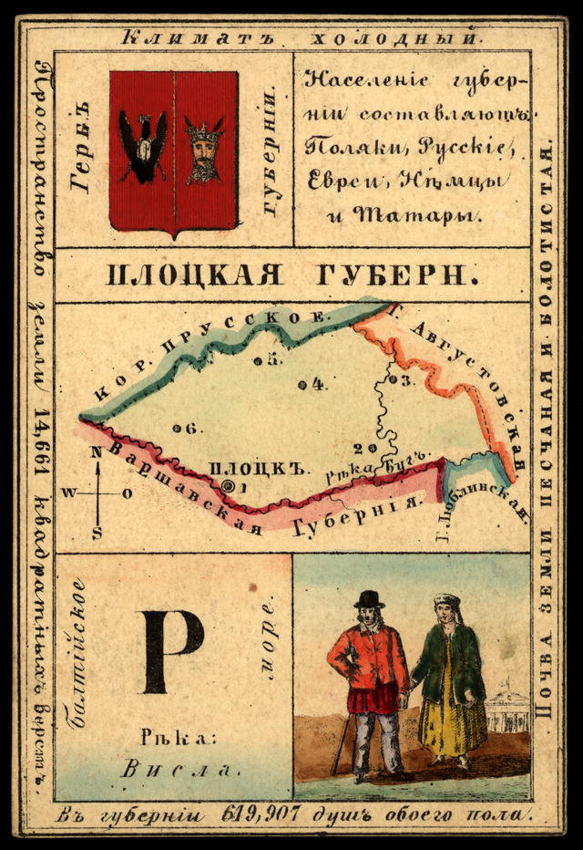

Płock Governorate- one of the 10 provinces of the Kingdom of Poland; in the present borders formed 1894; located in the northwest. the edges. Space 8358 sq. V. Rivers: Narew, Vistula and their tributaries; surface flat. The soil is loamy and sandy loam, suitable for arable farming (rye, potatoes, oats, wheat, etc.).
Perm province


Perm province administrative unit of the Russian Empire and the USSR in 1781-1923. It was located on both slopes of the Ural Mountains. The administrative center of the province was the city of Perm. On November 20 (December 1), 1780, Empress Catherine II signed a decree on the creation of the Perm governorship consisting of two regions - Perm and Yekaterinburg, and the establishment of the provincial city of Perm.
Penza province


Penza province administrative-territorial unit of the Russian Empire. Center - the city of Penza. Occupied 34129.1 sq. verst or 3,555,115 acres between 52°38" -54°5" north latitude and 40°27?" - 44°31" east longitude from Greenwich. It bordered in the west with Tambov, in the south with Saratov, in the east with Simbirsk, and in the north with Nizhny Novgorod. The surface of the province is quite undulating with gentle hills and sometimes deep river valleys. These valleys are flooded with rivers in the spring. The highest areas of the province are located in its southern part, in the districts of Chembarsky, Nizhne-Lomovsky, Penza and Gorodishchensky.
Oryol province


Oryol province administrative unit of the Russian Empire. The center is the city of Orel. It was established on December 12, 1796 by transformation from the Oryol governorship and abolished in 1928. The most ancient inhabitants of the Oryol region were the Vyatichi; The first cities, a stronghold against attacks by the Pechenegs and Polovtsians, appeared from the beginning of the 11th century. At the same time, Christianity began to penetrate here, which, however, spread no earlier than the 12th century, during the preaching of Saint Kuksha, one of the first enlighteners of the region. From the beginning of the XII to the half of the XIII century. in the region there were the principalities of Vshchizhskoye, Yeletskoye, Trubchevskoye and Karachevskoye.
Orenburg province


Orenburg province administrative unit of the Russian Empire. The center is the city of Orenburg. The Orenburg province was located in the South-East of the European part of Russia and had an area of 190 square meters. km. The Southern Urals crosses the province, with its individual peaks (Yaman-Tau) reaching 1640 m. The mountain slopes are covered with forests (up to 2 thousand sq. km). The Eastern Asian part of the province and the South are steppe in nature. The soil in mountainous areas is rocky, in steppe areas it is black soil.
Olonets province


Olonets province administrative unit of the Russian Empire. The provincial city was Petrozavodsk. It existed from 1801 to 1922. On September 18, 1922, the All-Russian Central Executive Committee, by its decree, abolished the province and divided its territory. By area in 1914 it occupied 130,801 km?. The population according to the 1897 census is 364,156 people).
Transbaikal region


Transbaikal region administrative unit within the Russian Empire. Formed in 1851. In 1922, it was transformed into the Transbaikal province. The Transbaikal region was located in Eastern Siberia, southeast of Lake Baikal, between this lake and the Chinese border, bordered on the west and north by the Irkutsk province, from which it was separated almost along its entire length by Lake Baikal and the Yakutsk region , in the east - with the Amur region. Part of the eastern and southern borders of the region were also the state border with the Chinese Empire (Manchuria and Mongolia).
Novgorod province


Novgorod province administrative-territorial unit of Russia (from 1727 to 1927) with its center in the city of Novgorod. In terms of area (from 1859 to 1917) it was the 11th territorial entity in the European part of Russia. The Novgorod province, which was part of the so-called Lakeside region, was located in the north-west of the Russian Plain. In the north it bordered with St. Petersburg and Olonets, in the south - with Yaroslavl, Tver and part of Pskov, in the east - with Vologda, in the west - with Pskov and St. Petersburg provinces.
Nyland Governorate


Nyland Governorate in southern Finland, adjacent to the Gulf of Finland; 11790 sq. km. (10363, sq. v.). The coastal part of N. is heavily indented by bays and dotted with skerries; for the safety of navigation, a network of lighthouses has been built here. The surface of N. is uneven, the mountains are rocky, but not high (up to 250 ft.); many forests. The rivers are mostly insignificant (Kyummen, etc.): there are many lakes in the north. Breaking granite. The climate is mild (in Helsingf. average annual temperature is +4.1°, fruit trees grow successfully (apples, pears, plums and cherries).
Moscow province


Moscow province administrative-territorial unit of the Russian Empire and the RSFSR, which existed in 1708-1929. Provincial city - Moscow. The Moscow province was located in the center of the European part of the Russian Empire, bordered in the north and north-west by Tver, in the north-east and east - by Vladimir, in the south-east - by Ryazan, in the south - by Tula and Kaluga, in the west - by Smolensk provinces. The area of the province was 128,600 km? in 1708, 32,436 km? - in 1847, 33,271 km? - in 1905, 44,569 km? - in 1926.
Mogilev province


Mogilev province administrative-territorial unit in the west of the Russian Empire. It was formed in 1772 after the first partition of the Polish-Lithuanian Commonwealth from part of the Belarusian territories that went to Russia (the northern part became part of the Pskov province). Initially, the Mogilev province included the Mogilev, Mstislavl, Orsha and Rogachev provinces.
Minsk province


Minsk province administrative-territorial unit of the Russian Empire in 1793-1795 and 1796-1921 (in 1795-1796 it was called the Minsk governorship). Together with the Vilna, Kovno, Grodno, Mogilev and Vitebsk provinces it formed the North-Western Territory. At the beginning of the 20th century, its territory area was about 91,213 km², and its population was 2,539,100 people.
Lublin Governorate


Lublin Governorate one of 10 lips. Kingdom of Poland, to the southeast. parts of the region on the border with Galicia. Area 14796 sq. V.; the surface is a hill surrounded by river valleys, reaching 1050 feet in the center. (in Tomashovsky district). There are many forests, and in the north of the lips. The area has the character of woodland, sparsely populated and covered with lakes and peat bogs. The soil is mostly sandy, black soil protrudes in the southeast - in Grubeshovsk. u. Many rivers (Vepr, Tenev, etc.) of the Vistula system originate in L.
Livonia Governorate


Livonia Governorate one of the provinces is located along the shores of the Gulf of Riga; the islands of Ezel, Moon, Runo and others make up its separate county of Ezel. Area L. g. 42725 sq. V. (including islands -2496 sq. in.). The surface is wavy, especially in the south, between the Western rivers. Dvina and Aa (Lifl. Switzerland); higher point Geising-Kalns (1028 ft.). Rivers: Western Dvina, Aa, Pernava, Salis (flows into Riga Bay), Embakh (into Lake Peipus). Lakes up to 1 thousand: Chudskoe, Virts-Ervi (240 sq. in.), Burtnek, etc.
Kursk province


Kursk province administrative-territorial unit of the Russian Empire and the RSFSR. The province was formed in 1796[clarify], it was located in the central black earth zone of European Russia. The administrative center was the city of Kursk. As of 1914, it occupied an area of 40,821.1 versts? (?46,455 km?), population was 3,256,600 people
Courland Governorate


Courland Governorate Courland Governorate, (Kurland), in the Baltic region, occupies a peninsula between the Baltic Sea and the Gulf of Riga, and also stretches in a narrow strip to the left. bank of the Zap River. Dvina. The sea coast is sandy and has few bays. Area 23747 sq. V.; The surface in the east is flat and low-lying, in the west it is elevated (K. Switzerland along the Vindava River). - The soil is loamy (many swamps), and in the east it is clayey. Thanks to the admixture of lime, talc and organic. substances, the soil of K. is fertile.
Kuopio Governorate


Kuopio Governorate to the east parts of Finland, on the border of the Olonets province, in the region of the Savolakso-Karelian lakes. Space 37602 sq. in., including under lakes 6256 sq. V. The soil is rocky, there are many forests and swamps; the climate is harsh (average annual temperature for the city of K is +2.2°). There are 321,885 inhabitants, including 18 thousand in cities. The population is Finns of the Karelian tribe. Lutherans, Orthodox 10336. Cultivation means, slash farming is developed; Rye, barley, oats and potatoes are cultivated.
Kovno Governorate


Kovno Governorate in the west parts of Europe Russia, along the border with Prussia, part of the former Lithuania. Area -35316 sq. V. The surface is flat, hilly in places (up to 823 ft.); for the most part the soil is turfy loamy and sandy loam, suitable for arable farming; a lot of swamps. Limestone, gypsum, sandstones, pottery clay, ironstone. In Ponevezhsky, Novo-Alexandrovsk. and Kovensk. uh. sulfur and ferruginous waters. Forests occupy 1/6 of the province's area; coniferous (60%) and deciduous species. The fauna is rich. The climate is moderate, average for the city of Kovno. pace. +6.2°.- The rivers of K. belong to the Baltic basin; Neman (in the province 130th century) and Vindava. There are up to 600 lakes, all small; fishing is developed. - The population lives in 9 cities, 236 towns and 24,396 villages. and other populated areas. points. There are 1684 thousand inhabitants, of which 147 thousand are in cities.
Kostroma province


Kostroma province was located in the center of the European part of the Russian Empire. It bordered in the west with Yaroslavl, in the south with Vladimir and Nizhny Novgorod, in the east with Vyatka, in the north and north-west with Vologda provinces.
On May 29, 1719, the Kostroma province was created in the Moscow province and the Galician province in the Arkhangelsk province. On March 6, 1778, the Kostroma governorate was created from these two provinces; the governorship was divided into two regions: Kostroma with a center in Kostroma and Unzhenskaya with a center in Unzha. On December 12, 1796, the governorship was transformed into the Kostroma province. After the October Revolution of 1917, the Kostroma province became part of the Russian Soviet Federative Socialist Republic (RSFSR) formed in 1918. In 1922, Varnavinsky and Vetluzhsky districts were transferred to the Nizhny Novgorod province. By a resolution of the Presidium of the All-Russian Central Executive Committee of January 14, 1929, the provinces were completely liquidated. The territory of the Kostroma province became part of the Kostroma district of the Ivanovo Industrial Region.
Kyiv province


Kyiv province occupied the northeastern corner of the southwestern region and was located along the middle reaches of the Dnieper River. In the north it extends to 51°30" north latitude, in the west - to 1°50" west longitude (from Pulkovo), in the east - to 2°40" east longitude (from Pulkovo), in the south - to 48°25" northern latitude. In the north it borders with the Minsk province, in the west - with the Volyn and Podolsk provinces, in the south - with the Podolsk and Kherson provinces, in the east - with the Chernigov and Poltava provinces. Natural borders exist only in the east (the Dnieper River for 406 versts, namely with the Chernigov province - for 136 versts and with Poltava - 270 versts). The greatest extent of the K. province from north to south is about 316 versts, from west to east about 337 versts. The entire area of the province is, according to military topographic surveys, 44,730 square meters. versts, according to Schweitzer's measurement - 44414 sq. versts, according to the calculations of General Strelbitsky - 44,800 square meters. versts, according to the local statistical committee (excluding rivers, lakes, roads and populated areas) 4,110,364 dessiatinas or 39,459? sq. verst.a was renamed Nikolaevskaya. Kherson became the district center of the Nikolaev province.
Kherson province


Kherson province The province was founded in 1803 by Alexander I by decree of May 15 No. 20760, when the center was transferred from Nikolaev to Kherson. The province existed until 1922, then part of it became Nikolaevskaya. By decree of the Senate of October 8, 1802, the Novorossiysk province was divided into Ekaterinoslav, Nikolaev and Tauride provinces. Kherson district became part of the Nikolaev province. The Nikolaev province existed for less than a year. By decree of the Senate of May 15, 1803, the provincial administration from Nikolaev was transferred to Kherson and the province began to be called Kherson. Until the end of the 19th century, there were no significant administrative and territorial changes in the Kherson region. In March 1918, three northern districts, including Dnieper, moved from Crimea to Ukraine; it became an integral part of the Kherson province. On January 28, 1920, the All-Ukrainian Revolutionary Committee adopted a resolution on the division of the Kherson province into Kherson and Odessa. Nikolaev became the center of the Kherson province. In December 1920, the Kherson province was renamed Nikolaev province. Kherson became the district center of the Nikolaev province.
Kharkov province


Kharkov province- In 1765, Slobozhanshchina received the official name of the Sloboda-Ukrainian province with its center in Kharkov. On April 25, 1780, the Decree of Empress Catherine II “On the establishment of the Kharkov Province and on the formation of 15 districts” was signed. In 1796, the governorships were abolished, and therefore the Sloboda-Ukrainian province, divided into 10 districts, was restored on the territory of the Kharkov governorship. In 1835, the Sloboda-Ukrainian province was again abolished and in its place the Kharkov province was created, which consisted of 11 districts. The administrative division was finally formed by 1856, when the province included 13 counties. Judicial power and military district administration for the Kharkov, Kursk, Voronezh, Oryol, Yekaterinoslav and Tambov provinces were concentrated in Kharkov.
In June 1925, the Kharkov province was abolished, and the districts that were part of it became subordinate directly to the capital of the Ukrainian SSR (the city of Kharkov).
Kazan province


Kazan province- belongs to the central Volga provinces and occupies a space (according to Strelbitsky’s calculation) of 55,987 square meters. ver., including under lakes (in Chistopolsky, Laishevsky and Spassky district) 32.5 sq. ver. The area of the province is divided pp. Volga and Kama into three parts, sharply different from each other. The first part of the province, occupying the entire space between the left bank of the Volga and the right bank of the Kama, in the east. its half represents terrain crossed by ravines, especially in Mamadyshsky district, and in the west. half, in uh. Tsarevokokshaysky and part of Cheboksary, Kozmodemyansky and Kazansky - a flat, swampy surface covered with forest. The second part of the province, southeast, lying between the left banks of pp. Volga and Kama, has a steppe character and only in the north. parts of Chistopol district area adjacent to the river. Kame has a wavy character.
Caucasian region


Caucasian region- represents a vast country located (at 46?-38?° north latitude and 37°20"-50°20" east long. from Greenwich) between the Black (with the Azov) and Caspian seas (K., or Ponto -Caspian, isthmus) to the west and east, and European Russia, Turkey and Persia to the north and south; this country consists of 6 provinces, 4 regions and 2 districts, administratively constituting a separate part of the Russian Empire, governed on the basis of the “Institution of Administration of the K. Territory”, approved by the Highest on April 26, 1883.
Podolsk province


Podolsk province- administrative unit of the Russian Empire. The center is the city of Kamenets-Podolsky, since 1914 - Vinnitsa.
It bordered on the west with Austria-Hungary (Galicia), and for about 180 km the border was the Zbruch River, the left tributary of the Dniester; in the north - with the Volyn province, in the east - with the Kiev province, in the southeast and partly in the south - with Kherson, in the southwest - with the Bessarabia province, from which it is separated by the Dniester River. Area - approx. 42 thousand km (according to Schweitzer - 42,400 km).
Kaluga province


Kaluga province- - was located in the central, Moscow region part of European Russia. Area - 27,686 sq. versts The surface is flat, only the western counties are hilly - Medynsky (up to 910 feet), Kozelsky and Mosalsky. The southern (Zhizdrinsky district) and eastern (Kaluga, Maloyaroslavsky and Likhvinsky districts) total forest area covers about 1/3 of the province. The soil is sandy loam and loamy, infertile. The mineral wealth of the province is significant, especially in the southern part (Zhizdrinsky district), in which the Maltsevsky factories are located. Iron ore is mined here; coal, phosphorites and refractory clays (Likhvinsky and Tarussky districts).
Irkutsk province


Irkutsk province- province of the Russian Empire and the RSFSR in 1764-1926. The capital is Irkutsk. In 1900 it consisted of five districts and one county. In 1708, the Siberian order was liquidated and the Siberian province was formed (from Vyatka to Kamchatka). The Siberian province in 1764 was renamed the Siberian Kingdom, which was divided into the Tobolsk and Irkutsk general governorships. In 1805, the Yakut region was separated from the Irkutsk province. After the February Revolution of 1917, the previously existing Irkutsk Governor-General, which included the Irkutsk and Yenisei provinces, Transbaikal and Yakutsk regions, ceased to exist. On August 15, 1924, the territory of the Irkutsk province was divided into 3 districts - Irkutsk, Tulunsky, Kirensky and 2 industrial districts - Cheremkhovsky and Bodaibinsky. On May 25, 1925, by decree of the All-Russian Central Executive Committee, the Siberian Territory was formed. Irkutsk province became part of it. On June 28, 1926, by resolution of the All-Russian Central Executive Committee, the Irkutsk province was abolished, and 3 districts were created on its territory - Irkutsk, Tulunsky and Kirensky.
Yaroslavl province


Yaroslavl province- a province of the Russian Empire, then the RSFSR with its center in Yaroslavl, which existed in 1777-1929 in the northeastern part of European Russia, in the upper Volga region, between 57°49" and 60°5" N latitude. and 38°25" and 42°5" E. The greatest extent of the province was in the direction from north to south between the northern end of Poshekhonsky district and southern Rostov, approximately 270 km, the greatest width from east to west between the eastern end of Lyubimsky district and western Mologsky - 231 km. The area of the Yaroslavl province is 35,615 km - 45th place among the 50 provinces of European Russia.
Yakut region


Yakut region- located between 54° and 73° N. w. and 103° and 171° east. d.; borders on the N. N. Ledov. ocean, in the western Yenisei province, the border with which is pp. Ilimcea, pr. Lower Tunguska, and Anabar, flowing into the North. Ice. ocean; between these rivers the border is an imaginary broken line, shown on our maps so that pp., wholly belonging to the Yaroslavl region. - Olenek and Vilyui - are represented as originating in the Yenisei province.
Tiflis province


Tiflis province- occupies the central part of Transcaucasia; has the appearance of an irregular polygon, elongated from NW to SE; It borders on the north and north with the Terek and Dagestan regions, on the west with the Kutais province, and on the south with the Kars region. and Erivan province, to the southeast and east - from Elizavetpolskaya. 39197 sq. V. (44607 sq. km). 9 districts (Tiflis, Akhalkalaki, Akhaltsikhe, Borchalinsky, Gori, Dusheti, Sighnakh, Telavi and Tioneti) and 1 district (Zagatala). The greatest extent of the lips. from NW to SE - about 350 ver., from N to South - about 200 ver.
Shemakha province


Shemakha province- was formed by the highest decree of December 14, 1846. In 1859, Shamakhi was destroyed by an earthquake, provincial institutions were transferred to Baku, and the province was renamed Baku Governorate.
Kutaisi province


Kutaisi province- administrative unit of the Russian Empire. It was located in the southwest of Transcaucasia, along the southeastern coast of the Black Sea and along the Rioni and Chorokha river basin. Area 25,942 sq. versts The surface in the north is mountainous - the southern slopes of the main Caucasus (Dykh-Tau, 17 thousand feet in height); the middle part, along the Rioni River, is flat, swampy in places, lowland; the southern part of the province is occupied by the Lesser Caucasus. Forests cover about half of the total area. The soil in the mountainous areas is stony, in the lowlands it is alluvial and extremely fertile. The climate is mild, humid and even. The flora is luxurious subtropical (the homeland of the grapevine). Population 914 thousand people (urban 62 thousand). Georgians 842 thousand, thousand, Abkhazians 59 thousand, Russians 13 thousand, the rest are of other nationalities.
Derbent Governorate


Derbent Governorate- an administrative-territorial entity in the Russian Empire that existed in 1846-1860.
It was created by decree of Nicholas I on December 14, 1846 and included the Derbent and Kubinsky districts of the Caspian region, as well as the conquered Dagestan lands. The center of the province was Derbent.
In 1847, the province, together with the Tarkov Shamkhalate and the Mehtulin Khanate, formed a special administrative unit, the Caspian region. The Derbent province included the city of Derbent, the Derbent and Kubin districts, the Samur and Dargin districts, the Kyurinsky and Kazikumukh khanates, as well as the remaining lands south of the Avar Koisu. According to the establishment of 1855, the Caspian region consisted of two parts: the Derbent province and the lands of Northern and Mountainous Dagestan.
In accordance with the “Regulations on the Administration of the Dagestan Region” dated April 5, 1860, the Derbent province was abolished, and most of it (excluding the Kubinsky district) became part of the Dagestan region.
Grodno province


Grodno province- one of the northwestern provinces of the Russian Empire with its center in the city of Grodno. Reliable information about the current Grodno province - which in more distant times represented a country covered with impenetrable forest wilds and swamps and inhabited by the Yatvingians - begins in the 11th century, that is, from the time of the Slavs’ movement here. Around 1055, Slavic settlements appeared. At first, the country constituted a special Gorodny principality, which became part of Lithuania around the half of the 13th century. In 1501, when the Grand Duchy of Lithuania was divided into voivodeships, the northwestern part of the Grodno province belonged to the Troka voivodeship, the northeastern part to the Novogrudok voivodeship, and the southern part was originally the Narevsky voivodeship, and from 1520 the Podlassky voivodeship, which in 1596 formed the Brest voivodeship , merged with Poland. This administrative division marked the last partition of Poland. From the part that passed to Russia in 1795, the Slonim province was formed in 1796, consisting of 8 counties: Slonim, Novogrudok, Grodno, Volkovysk, Brest, Kobrin, Pruzhansky and Lida. A year later, in 1797, the Slonim province was united with the Vilna province, under the name of the Lithuanian province, and five years later, by decree of 1801, it was separated in its previous composition from the Vilna province, and was renamed Grodno. In this form, it existed for 40 years until the Bialystok region was annexed to it in 1842, which included 4 districts: Bialystok, Sokolsky, Belsky and Drogichinsky, and the latter was connected with Belsky into one district; Lida district went to the Vilna province, and Novogrudok to Minsk, so that the Grodno province now consists of 9 districts
Estonia Governorate


Estonia Governorate- the northernmost of the three provinces of the Baltic region, stretches in a strip from east to west along the southern coast of the Gulf of Finland and ends with an archipelago of islands. The extreme points of E. province: in the west - Cape Dagerort (Kalaninna) on the island of Dago (20°2" east longitude), in the east - the Narova River (near the city of Narva, 28°12" east longitude), in the north - the rocky Cape Stensker on the shore of the Gulf of Finland (59°49" north latitude), in the south - the island of Kerksar near the Gulf of Pernov (58°19" north latitude). In the west, the mainland part of the Estonian province is bordered by the Baltic Sea (297 versts), in the north by the Gulf of Finland (469 versts), in the east by the Narova River, which separates it from the St. Petersburg province (75 versts), in the south by Lake Peipus or Peipus and Livonia province (371 versts); more than 2/3 of the border line is water (not counting islands) and about 1/3 is land borders.
Erivan Governorate


Erivan Governorate was formed in July 1849 from the Armenian region, with the annexation of Alexandropol district. Since 1872, the province has consisted of 7 districts. The most important settlements, besides Erivan, are Alexandropol, Nakhichevan, Novo-Bayazet, Ordubad and Echmiadzin. Erivan province is located in the central part of southern Transcaucasia, between 41°7" and 38°52" latitude. and 60°56" and 63°54" E, forms an irregular parallelogram elongated from northwest to southeast; borders: in the north - with the Tiflis and Elizavetpol provinces, in the east - with the Elizavetpol province, in the west - with the Kars region, in the south - with the Erzurum vilayet of Asian Turkey and with Persia.
Yenisei province


Yenisei province- an administrative-territorial unit within the Russian Empire and the RSFSR in 1822-1925. “In the scarlet shield there is a golden lion with azure eyes and a tongue and black claws, holding the same sickle in his right paw. The shield is crowned with an imperial crown and surrounded by golden oak leaves connected by St. Andrew's ribbon." The coat of arms of the Yenisei province was approved on July 5, 1878. In 1886, the armorial department of the Department of Heraldry removed decorations from city shields. The lion symbolized strength and courage, and the sickle and shovel reflected the main occupation of the inhabitants - agriculture and mining, primarily gold.
Ekaterinoslav province


>Ekaterinoslav province- bordered in the north with the Poltava and Kharkov provinces, in the east - with the region of the Don Army, in the south - with the Sea of Azov and the Tauride province, in the west - with the Kherson province. The greatest extent of the province from north to south is 252 versts, from west to east - 463 1/2 versts. According to military topographic survey, the area is 55688.4 square meters. versts, or about 5730 thousand dessiatinas; according to the Central Statistical Committee (excluding lakes and estuaries) 55704.4 square meters. verst = 5635737 dessiatines. The surface of the province is a steppe plain, with two slopes to the north and south and several hills. The highest point of the province, 400 m above sea level, is located in the southern part of the Slavyanoserbsky district; here is the watershed of the tributaries of the Donets and the rivers of the Azov Sea. The remaining hills lie in the Pavlograd and Novomoskovsk districts, along the Oreli, Orelka and Samara rivers, and in the west of the province, where a granite ridge crosses the Dnieper, Ingulets and Kalmius, forming rapids on them (tashlyks, Kamenki).
Chukotka land and Kamchatka region


Chukotka land and Kamchatka region. The Kamchatka region was first formed as part of the Irkutsk province in 1803. Nizhnekamchatsk was appointed the center of the region. In 1822 the region was abolished. Instead, the Kamchatka coastal administration was created as part of the Irkutsk province with its center in Petropavlovsk-Kamchatsky. In 1849, the Kamchatka region was re-created from the Kamchatka coastal administration and the Gizhiginsky district of the Okhotsk coastal administration. However, already in 1856, the Kamchatka region was abolished, and its territory became part of the Primorsky region. In 1909, the Kamchatka region was created for the third time. In 1922, the Kamchatka region was transformed into the Kamchatka province
Chernigov province


Chernigov province located between 50°15" and 53°19" north latitude and 30° 24" and 34°26" east longitude; has the shape of a quadrangle, widened in the south, with a chipped upper left corner. The northern and southern borders of the province have an outline that is closer to straight, almost parallel lines; the mentioned cut in the upper part of the western border corresponds to two main breaks of the eastern border, giving cuts from its territory and from this side
Bessarabian Governorate


Bessarabian Governorate formed the extreme southwestern corner of Russia, between the Prut in the west and the Dniester in the north and east; The Danube (actually the northern one, its Chilia branch) formed the border in the south, the Black Sea in the southeast, only in the extreme north-west did the province not have well-defined natural borders; It was separated from the Austrian region of Bukovina by small rivers flowing into the Prut and Dniester, and part of the border between them was drawn by fields. The Prut and Danube separated the Bessarabia province from the Romanian kingdom, namely the former from Moldavia, and the latter from Dobruja, which was annexed to Romania according to the Berlin Treaty.
Augustow Governorate


Augustow Governorate- (Polish: Gubernia augustowska) in the administrative unit of the Kingdom of Poland, which existed in 1837–1866 with its center in Suwalki. It was divided into 5 counties: Augustow, Kalvariy, Lomzhinsky, Mariampolsky and Sejnsky. The Augustow province was abolished in connection with the Decree of December 31, 1866. Poland was divided into 10 provinces and 85 counties. The territory of the province became part of the newly created Suwalki and Lomzhinsk provinces.
|
| ||||||||
I.V. Maslova
Elabuga State Pedagogical University
PROVINCIAL COUNTY CITY OF THE RUSSIAN EMPIRE OF THE 19th - EARLY 20TH CENTURIES: BASED ON THE MATERIALS OF THE VYATKA PROVINCE
District city of the Russian province of the 19th century. was an excellent example of the combination of the commercial activity of townspeople and the historically established patriarchal way of life, with its characteristic traditions and rules of behavior.
According to the classification according to administrative characteristics in pre-revolutionary Russia there were:
- capitals: large cities with a population of 100 thousand or more people;
- provincial cities: medium-sized cities with a population of 20-100 thousand people;
- county or small towns: with a population of 5 to 20 thousand people;
- provincial or districtless cities: town-village with a population of up to 5 thousand inhabitants.
Firstly, provincial cities, despite their provincial status, tried with all their might to adopt the capital’s way of life, and the dynamics of life, the level of migration processes in them was much higher, which ensured the modernization of various spheres of life, a departure from the traditions of provincial urban culture.
Secondly, the county town was closely connected with the agricultural district, which created conditions for the widespread preservation of traditional folk culture in it. The district city thus became the custodian of folk traditions in the national culture.
Thirdly, the numerical superiority among provincial cities was undoubtedly on the side of the district ones. Therefore, it is in them that the traditional urban sociocultural environment, despite the influence of factors specific to individual cities (economic, geographic, demographic, ethnocultural, environmental, etc.), is embodied in a number of characteristic features.
In Russia, the concept of “province” initially reflected territorial division, denoting an administrative unit within the province. By the beginning of the 19th century. it began to acquire the character of secondary, then derogatory. However, the perception of the province as a kind of “backwater”, provincial culture as second-rate, inferior to the capital’s, is not correct. The province lived its own unique life, which is clearly illustrated by the history of the provincial city. Outwardly, the provincial city repeated the capital: the same classes, administrative structures, educational institutions. But in an effort to reach the metropolitan level, each provincial city offered its own version, determined by historical fate, established traditions, and a tendency to accept certain newfangled trends.
In the typology of the Russian provincial county town of the 19th century. A number of characteristic features can be identified:
Firstly, the type of new provincial county town mainly developed at the end of the 18th - first half of the 19th centuries. As a result of the provincial reform of 1775, the granting of letters of rights and benefits to cities (1785), the administrative-territorial structure of the province and the hierarchy of cities were formed.
Secondly, an important chronological facet in the development of the city was the bourgeois reforms of the 60-70s. XIX century, which caused rapid growth in urban population.
Thirdly, the predominant type of provincial county town of the 19th century. was a commercial and administrative city, which was the local trading center of the rural district.
Fourthly, the provincial provincial town was small in number: 5-10 thousand inhabitants.
In the XIX - early XX centuries. The Vyatka province included 10 district towns. The development of entrepreneurial activity in cities was facilitated by the favorable geographical location of the province. It found itself at the intersection of large transport highways: the Kama and Vyatka river routes with the direction to large shopping centers: Kazan, Nizhny Novgorod, St. Petersburg, Moscow, Arkhangelsk, Astrakhan. Large rivers were served by steam ships. The most important river for navigation was the Kama River. “Flowing through the most grain-producing districts: Sarapul and Yelabuga, it serves the merchants as the main communication in their trade relations with the lower and other Volga cities.”
There were 8 piers on the Kama: Krymsko-Slutskaya, Karakulinskaya, Chagodinskaya, Pyany Bor, Ikskoye estuary, Elabuga, Svinogorskaya and Vyatskaya. In 1854, 478 river vessels were registered in the province. Dirt roads played an important role in cargo transportation. Highways of all-Russian significance passed through the territory of the Vyatka province: Siberian, Kazan, Vyatka-Ufa. The postal route in the province was 1,728 miles long and had 65 stations. . Small county highways and country roads were built from the leading communication routes, connecting the cities of the province.
Trade played a significant role in the economic development of county towns. In the 19th century Periodic forms of trade actively developed: fairs, markets and bazaars. The government stimulated the development of periodic trade by making it possible to freely sell agricultural products and handicrafts. According to the law, free “sale of supplies and agricultural products” was allowed at bazaars, fairs and markets without purchasing trade certificates and tickets.
Fair trade enlivened the life of the Volga-Kama region, gathering traders from remote places with a wide variety of products. By creating conditions for implementation, it stimulated the development of commercial agricultural and handicraft production.
Of no small importance in establishing the timing of the fairs was the time of their functioning in the nearest villages, since trade went as if in a circle, unsold goods wandered from one fair to another. That is why the city society of Yelabuga in 1868 asked to postpone the dates of the fair from December to the second half of August, because in December, the most popular Menzelin fair in the region took place. Since that time, the largest Spasskaya fair in Elabuga was held from August 15 to 21.
The most significant fair in the province was Alekseevskaya, which took place in Kotelnich from March 1 to 23. The fair was opened under Tsar Alexei Mikhailovich, in whose honor it received its name. In 1844, a permanent fair committee was formed, and from that time the fair's turnover expanded significantly. Merchants came to the fair not only from the cities of the Vyatka province, but from all over Russia. Factory owners brought red goods and teaware from the Moscow and Vladimir provinces; from Kostroma - tea and sugar, from Yaroslavskaya - linens; from Nizhny Novgorod - hat goods; from Tula - iron and steel products. Preparations for the fair trades began back in February, when city residents began to build benches and booths, huts with stoves. On the river where horse trading took place, long railings were built and fences were erected into which hay was stored for sale. “On the 28th and 29th, carts with flour, malt, peas, salt, cereals and other things appear throughout the area... On March 1, drums are heard, the city flag is raised and the fair begins.”
From the first days of the fair's opening, the city became crowded and lively. “At this time, there are at least 12,000 visiting people here, and at least 15,000 people with city residents. Because of such crowdedness, few houses in the city are filled with a large number of different types of guests... In general, all residents of the city who have their own houses and receive guests receive at least 4,000 rubles from visiting merchants. From this alone it is clear that the Kotelnicheskaya Fair, although it cannot become along with other extensive fairs in Russia, can still be very useful for its people and its poor inhabitants, who can make some money during it.”
Fairs of county towns differed in trade specialization and different sizes of trade turnover. In 1858, the turnover of the Alekseevskaya Fair in Kotelnich amounted to 706,099 rubles. The fair began with horse trading, and then the trade counters were filled with a variety of goods: textiles, groceries, tea, sugar, fur goods, etc. At the beginning of the 20th century. There were 4 fairs in Slobodsky. At the largest of them, held “on the tenth Sunday after Easter,” trade was carried out in the amount of 10,000 rubles. The main types of goods at this fair were canvas, textiles, and wool. The autumn fair, which usually began on September 14, was famous for the sale of agricultural products, but the volume of trade turnover at it was 1000 times smaller. The geographical area of fair participants was quite wide. In the conditions of the established all-Russian market, the trade specialization of individual regions was clearly visible. Raw leather, hemp, flax, grain products, flaxseed and hemp seed, fresh fish, partially lard and oil, wooden products, horses, and cattle were usually brought from neighboring villages of Yelabuga, Menzelinsky and Bugulminsky districts. The provincial buyer could not afford a trip to the largest Russian fairs (Nizhny Novgorod, Irbit), so unsold goods from these fairs were often sold at regional fairs held in county towns. The list of such “previously unsold goods” included cloth, cloth, groceries, tea, and pot paint.
Tanned leather goods: boots, shoes - were brought from Sarapul and Moscow. The grain came from Kazan, from the Menzelinskaya and Bugulminskaya fairs, salt mainly from Perm.
According to tradition, fairs were held on patronal holidays, with large crowds of people. These days it was customary to have fun and walk. Therefore, an integral element of the fair were booths in which artists performed and played games of chance: spinning top and torch. It is no coincidence that there was a popular saying about the Kotelnikov fair: “They traded quietly, feasted noisily, and the whole fair was here!” .
Unlike fairs, which lasted on average from 5 to 15 days, the auctions took place only for one day and coincided with religious holidays. For example, the market in the village of Alnashi took place on Trinity Day. And on Easter it was possible to purchase goods at the market in the village. Ilyinskoe. In total, in Yelabuga district alone there were 45 markets.
Another form of trade organization was bazaars, which were held weekly. In the Vyatka province, on average, each district had from 4 to 6 bazaars, held in various villages. You could buy the necessary goods every Sunday at the market in the village of Alekseevskoye. On Wednesdays, a bazaar awaited its buyers and sellers in the village of Starye Yurashi. In the absence of stationary retail outlets in most villages of the district, markets and bazaars allowed the population to satisfy their needs for essential goods.
The periodic sphere of the market was used by merchants as a place for the formation of wholesale cargo. Sales most often had a multi-stage nature. Many goods entering the market passed through the hands of three or four intermediaries. Agricultural products were bought by cart loads by resellers, often played by clerks of wealthy merchants, and delivered to storage facilities - “storage barns” located on river piers. Direct purchases of grain were also made in storage barns, which were delivered here by peasants. The formation of wholesale lots of agricultural products also took place in addition to bazaars, directly by buying from houses through resellers, most often wealthy peasant moneylenders. The formation of wholesale cargo when purchasing from the yard was typical for grain products, as well as for flaxseed, linen, eggs, and honey.
In general, periodic types of trade not only contributed to the accumulation of trade capital in the hands of large merchants, but also stimulated the development of ties between the urban population and the peasants of adjacent counties.
In the 19th century The overwhelming majority of residents of the district towns of the Vyatka province were Russian, but still the townspeople were not homogeneous in their ethnic composition. People from various regions of Russia came to the cities of the province. All of them were carriers of different worldviews and had different social and national origins. In part, the ethnic composition of the townspeople can be judged based on what religion they professed. According to the First General Census of the Russian Empire, the overwhelming majority of the townspeople of the Vyatka province professed official Orthodoxy - 96.2%. Old Believers accounted for only 2.03%. Muslims made up 2.7% of the total number of residents of the district towns of the province.
In the middle of the 19th century. The social composition of the population of the district towns of the Vyatka province was dominated by burghers, who made up 59% of the total population of the district towns. But the decisive role in economic and social life was played by the merchants, who made up 10.9% of the townspeople.
The merchants not only set the tone for the economic development of the district city, but also influenced the formation of its external appearance. It is worth highlighting some characteristic features characteristic of the appearance of the county town. In the first half of the 19th century. In the cities of the Vyatka province, wooden construction predominated in both residential and industrial architecture. A careful analysis reveals a clear relationship between the amount of guild capital and stone construction. In the district towns, where the largest number of merchants of the 1st and 2nd guilds lived, there were more stone houses. In particular, the cities leading in terms of the amount of merchant capital: Yelabuga, Sarapul and Slobodskoy, confidently took the lead in the pace of stone construction of residential buildings. In the second half of the 19th century. In connection with the active development of business activity, as well as in order to avoid or at least reduce the number of fires, stone urban planning began to develop more actively.
Gradually, entire streets were formed in cities, the development of which corresponded to the standard of living and social class of their residents. In Elabuga, on the central street of the city, Bolshaya Pokrovskaya, there were only stone two-story mansions and estates of merchants of the 1st guild, as well as several administrative buildings. Since 1850, Kazanskaya Street, which runs parallel to it, has been built up with stone houses and shops belonging to the guild merchants. On the next Malmyzhskaya street, where small stone buildings interspersed with wooden houses, lived mostly tradesmen. And the names of the streets reveal the social status of their residents. For example, people called Bolshaya Pokrovskaya Street in Yelabuga Millionnaya, because It was inhabited not just by the first guild merchants, but mostly by millionaire merchants. Kupecheskaya Street also existed in Nolinsk. Analyzing the names of the streets of county towns, it should be noted that they reflected the religiosity of the townspeople, because the street was traditionally named after the temple or monastery that was located on it. This is how Rozhdestvenskaya Street in Slobodskoye, Spasskaya in Yelabuga, and Predtechenskaya in Kotelnich appeared. Another principle that guided the naming of the street was its orientation to the neighboring city or village, which emphasized the internal connections (including trade) established between the settlements of the Vyatka province. An example is Urzhumskaya street in Nolinsk, Vyatskaya in Kotelnich, Malmyzhskaya in Elabuga.
In the center of the county town there was a main cathedral, in front of which the city's central trading square was usually located. It was here that the stone Living Rows were erected, and wooden benches and cabinets with goods were located. For example, in Kotelnich, to the south of the city cathedral, on the shopping square there were two old Gostiny rows with 165 shops. And in 1852, to the west of the cathedral, a stone Gostiny Dvor with 120 benches was built. In Yelabuga, in front of the Spassky Cathedral, the main market is located - the busiest place in the city. For the convenience of sellers and buyers on Spasskaya trading square, at the expense of the merchant I.I. Stakheev, Gostiny Dvor was built, consisting of two buildings of stone shopping arcades. They were a complex of retail and warehouse premises. Barns for storing large quantities of goods were located in the basements of shopping arcades. Small quantities of goods were presented in a rented shop. Rent from all trading places went to the city treasury. The central shopping area of Slobodsky also had convenient retail premises - the stone Gostiny Dvor with 100 shops.
The internal structure of the city was clearly regulated already in the first third of the 19th century. In the report of the Vyatka governor to the Minister of Internal Affairs in 1838, it was reported: “Squares and markets are arranged properly, and kept clean and tidy; houses are built in cities according to established drawings, which are first checked by the construction commission.”
In each county town, administrative buildings (City Duma, council, treasury, etc.), educational institutions (gymnasiums, real schools, parochial schools), almshouses maintained by charitable donations were built.
An integral feature of city life were drinking establishments, which were located mainly in the main shopping areas. As mentioned above, the trading area was traditionally located next to the church or cathedral. Therefore, in the county town, where the merchants were actively involved in the wine trade, an unsightly picture was created of the proximity of a religious institution, the purpose of which was to take care of people’s morality, and a tavern, which implements directly opposite tasks. In the statement of the Treasury Chamber about the existing drinking houses in the Vyatka province in 1805-1807. drinking houses are listed on Spasskaya and Pokrovskaya squares in Yelabuga, in Slobodskoye on the square near the Transfiguration Cathedral and on Bread Square, etc. etc.
With the development of entrepreneurship in the second half of the 19th - early 20th centuries. Industrial buildings of factories and factories began to appear in cities. Almost every city had a distillery: in Slobodskoye it was the plant of the trading house “Heirs of I.V. Alexandrov”, in Elabuga Brewery and mead factory of the trading house “I.G. Stakheev and heirs”, in Sarapul distillery production of “Izhevsk Torg. prom. partnership." Merchant enterprises covered almost all branches of the manufacturing industry.
In the 19th century County towns began to be actively improved, and a public utilities system was created. In the first half of the 19th century. Public water pipes began to appear in the cities of European Russia.
During this period, a small branch of the water pipeline with wooden pipes was built in Sarapul, through which water flowed by gravity from the springs into specially constructed reservoirs - “pools”. In 1884, merchant A.T. Shitov built a new branch of the water pipeline, delivering spring water to his dacha, to a real school, a convent and to the reservoirs of two squares in Sarapul. Despite the increase in the length of the water pipeline, the problem of supplying the population with drinking water remained open, because In winter, the pipes quickly froze, and in addition, there was no water supply to the city outskirts. At the expense of the merchants of the second guild N.F. Baranshchikova and M.P. Kurbatov in 1893, a second water supply line was built. The improvement of the city was continued by the merchant of the second guild P.A. Bashenin, who during his service as city mayor built a regular water supply system and a power plant.
In general, not only the economic well-being of the county town, but also its appearance depended on the level of development of merchants’ commercial activities. Benches and stores, guest courtyards, taverns, entire streets of stone merchant buildings transformed the appearance of the urban Russian province. The sociocultural environment of the county town is losing the features of a rural settlement and acquiring an urban capitalist character.
Bibliography:
1. Alekseevskaya Fair // Vyatka Provincial Gazette. 1839. Addition to No. 18. P. 34.
2. Animitsa E.G., Medvedeva I.A., Sukhikh V.A. Small and medium-sized cities: scientific and theoretical aspects of research: Monograph. Ekaterinburg: Ural. state econ. University, 2003.
3. Blinov N.N. Sarapul and the Middle Kama region: past and present: Essays with drawings. Sarapul: Pipolitography I.M. Kolchina, 1908.
4. Vyatka Provincial Gazette. 1858. No. 14.
5. Vyatka region. 1897. March 15.
6. GAKO. F. 176. Op. 1. D. 3547. L. 576.
7. GAKO. F. 574. Op. 2. D. 246. L. 19.
8. GAKO. F. 582. Op. 26. D. 1099. L. 1.
9. GAKO. F. 582. Op. 92. D. 101. L. 15.
10. GAKO. F. 582. Op. 99. D. 14. L. 174-176.
11. GAKO. F. 582. Op. 140. D.98. Ll. 4, 28.
12. GAKO. F. 582. Op. 140. D. 158. L. 87.
13. GAKO. F. 582. Op. 140. D. 178. L. 17 vol.
14. Glushkov I. Kotelnich XIX century. Topographical - statistical and ethnographic description of the city of Kotelnich. Historical sketch of the city of Kotelnich: Reprint. Kotelnich, 1999.
15. Koshman L.V. City and urban life in Russia in the 19th century: Social and cultural aspects. M.: ROSSPEN, 2008.
16. Ligenko N.P. Merchants of Udmurtia. Second half of the 19th - early 20th centuries: Monograph. Izhevsk: Udmurt Institute of History, Language and Literature, Ural Branch of the Russian Academy of Sciences, 2001.
17. The first general census of the Russian Empire in 1897, St. Petersburg. 1879-1905. X Vyatka province. P.84-85.
18. Semenov-Tyan-Shansky V.P. City and village in European Russia. St. Petersburg, 1910.
At the beginning of the 19th century. in the Oryol province The lack of land began to take its toll. There was a noticeable significant increase in population density, especially if we exclude from the general cadastre the lands that were in the use of the serf-owning nobles. The increase in population density under the corvee economy that existed at that time made serf labor unprofitable for landowners, since under the primitive economic system there was nowhere to put the excess serf labor, and forced labor left no way for improving agricultural production. The surplus serfs in the field farming were included in the household and increased the already huge household.
The most important act of the first years of the reign of Alexander I was the decree of February 20, 1803 on free cultivators. The legislative act allowed landowners to free their serfs alone or in entire villages, but not otherwise than with land plots, without which the release was prohibited.
The government begins to encourage the resettlement of peasants to the outskirts of the state. From the zone of population influx, Oryol province in the 19th century. turned into his exit zone. In the first half of the century, the average annual actual population growth was lower than natural. The movement of people from the province to the south and east, as well as to Moscow and St. Petersburg, is increasing.
If at the very beginning of the 19th century. our fellow countryman, a graduate of the Sevsk Theological Seminary, Professor Evdokim Zyablovsky, characterizing the economy of the Oryol region, emphasized that “the main exercise of the residents is arable farming, which is carried out here with great success, up to a million quarters of grain are exported from here every year,” then in the coming decades in the south of Russia A new grain production center began to form. The peasants of the Central zone, including the Oryol province, not being able to compete with the south in bread production, are increasingly concentrating their activities on the cultivation and processing of flax and hemp. In the “List of populated places in the Oryol province according to information from 1866” it was reported that “in the late 40s and early 50s in the Oryol province, hemp growers occupied up to 85 thousand dessiatines; by the beginning of the 60s, hemp sowing decreased by 7 thousand dessiatines.” Despite the attempts of individual landowners to improve their farming, three-field crop rotation still prevailed. They continued to plow with plows, sow by hand, and thresh with flails. Arable land expanded, although hayfields and pastures had to occupy an area at least twice as large in order to provide conditions for raising working livestock and obtaining a sufficient amount of organic fertilizers.
The main crops of the three-field region remained winter and spring rye, oats, barley, and wheat. The viability of the three-field with this set of crops was due to the fact that all of them were necessary on peasant farms. However, even the three-field area did not provide sufficient harvests. Then, in addition to it, farmers used methods of other systems - slash and fallow. So, in the 19th century. forest fallow (forest-field system), along with three-fields, existed in the forest belt of the Oryol region. In chernozem territories, three-field crop rotation was supplemented with autumn plowing (in autumn - from September to November) to preserve moisture and freeze out the roots of weeds; Winter crops were sown after spring crops in the same field, and the fallow field was sown with spring crops the following spring. This helped winter crops use winter moisture from the soil. To improve the fertility of the fields, buckwheat was grown, which cleared the fields of weeds; after harvesting, the soil was soft and rich. Due to the high demand for some crops, crops were changed: sometimes barley was sown after wheat, after barley - oats, after oats - buckwheat, then - winter rye; when sowing the latter, especially after buckwheat, the arable land was not plowed, they were sown over the stubble. To better clear fields of weeds, there was a whole range of measures: selection of seed material, timely sowing (weediness of seedlings is associated with sowing time), seeding of seeds not with a plow, but with a harrow, loosening and weeding of the soil, cleaning threshed bread from weed seeds, combating plant diseases .
Among the landowners there was a growing hope for the development of non-agricultural industries and for the ever greater entrenchment of the quitrent system. So, in November 1800, a message appeared in the St. Petersburg Gazette that retired brigadier Count S. F. Tolstoy, who lived on his Krom estate, began to develop peat deposits and use peat for heating instead of firewood. Peat was also used as fertilizer. In the Oryol province, potatoes were used in the first quarter of the 19th century. turned from a garden to a field crop and the area it occupied began to expand rapidly. Sugar beets began to be cultivated: previously, sugar was produced from sugar cane and was considered an overseas curiosity in Rus'.
The first beet sugar factory in Russia was built by the landowner Ya.S. Esipov and his companion E.I. Blankenagel in 1802 in the village of Nizhnee Alyabyevo (Chernsky district of the Tula province, now the village of Alyabyevo in the Mtsensk region), on the banks of the small river Studenets at its confluence with the Chern River. At the same time, 20 acres of sugar beets were sown here, the processing of which yielded 160 pounds of raw sugar, which was then transported to Moscow. Having received such a significant result, the landowner Esipov confidently declared that Russia would soon be able to independently provide itself with sugar. He proposed “setting up factories everywhere” in Russia and accepted students from all interested landowners into his factory for free training.
The Alyabyevsky plant, for the construction of which 32 thousand rubles were spent, made losses for the first three years, but already in 1807, after the enterprise switched to the production of refined sugar, the profit amounted to 11,686 rubles. In 1825, the plant burned down and was restored only in 1830. Sugar production in these years was organized in the mill premises. The main reason for the increase in sugar production from beets was the expansion of domestic market demand for these products. In addition, the fact that in the 1830s also played a role. The production of beet sugar has improved significantly. A mechanical beet grater and a hydraulic press for squeezing juice were introduced; The juice was clarified using bone charcoal (instead of the previously used ox blood), and the juice was heated and thickened using steam. As a result, already in the first decades of the 19th century. beet sugar factories appeared in Kursk, Voronezh, Smolensk and other provinces. And after the fire of 1854, the Alyabyevsky plant was no longer restored.
Kaluga landowner D. M. Poltoratsky, captivated by the experience of English agriculture, proposed at the beginning of the 19th century. four-field crop rotation. The first field is potatoes, the second is spring crops with clover sowing, the third is clover and the last is winter crops. The use of clover improved soil fertility, it was possible to keep livestock in large numbers, and this, in turn, solved the problem of fertilizing fields.
An opponent of Poltoratsky’s innovations, which aroused great interest among landowners of the Oryol province, was a native of Liven Count F.V. Rostopchin. He tried to create his own farming system. Rostopchin brought sheep from England, bulls and cows from the north of Russia, and ordered purebred horses from Arabia. The overseas herd became the core of a stud farm in the Liven village of Kozmodemyanovskoye. The breed of horses bred by Rostopchin (it was based on English and Arabian horses) won good fame in Russia. Horses have repeatedly won prizes at prestigious races and races. And soon the breed was nicknamed “Rostopchinskaya”.
Rostopchin was passionate not only about horses: he had crops of Syrian and American wheat, American oats, trying to increase productivity, tried to fertilize fields with silt from the bottom of ponds, added lime and copper sulfate to the soil. Initially, Rostopchin’s hopes for improving field cultivation were associated with the introduction of plows: following the example of Poltoratsky, he purchased several dozen of them at once. Soon the expectation of a miracle gave way to disappointment. Rostopchin began to prove that the Russian agricultural system, supposedly archaic in comparison with Western innovations, is in fact filled with inner meaning and is determined by climatic, soil, and demographic circumstances. Instead of blindly copying German and English techniques, Rostopchin suggested that landowners independently look for ways to increase the efficiency of their farms.
Rostopchin, in his book “The Plow and the Plow” (1806), argued that the promises of English agronomists were simply impossible to fulfill in the Russian climate; it was only necessary to borrow some of the tools necessary for threshing grain and other work. Such patriarchy was in many ways a typical feature of a certain part of the nobility of that time. For example, I. A. Krylov wrote the fable “The Gardener and the Philosopher,” which was consonant with Rostopchin’s ideas, and in 1810, the Tula landowner, a famous figure of Russian culture, Vasily Levshin, presented to the Free Economic Society a description of the agricultural implements that were used in the Kaluga, Tula, and Oryol provinces. Levshin suggested that the society organize descriptions of agricultural implements in other provinces.
Another contemporary of Rostopchin, Franz Christianovich Mayer (1783 - 1860), a German by nationality, largely shared these views. From 1817 to 1860, F. X. Mayer served as manager of the Mokhov estate of Shatilov (now the territory of the Novoderevenkovsky district of the Oryol region). Here he began work on soil conservation afforestation and developed effective methods for fertilizing fields and cultivating them. This is precisely what interested L.N. Tolstoy, who came to Mokhovoye in 1857 to clarify a number of economic and economic issues. Russia owes the science of artificial forest plantations to F. X. Mayer. He was elected a full member of the Free Economic Society, Moscow, Lebedyansky and a number of other agricultural societies.
However, despite a number of private innovations, the crisis of agriculture at the beginning of the 19th century. did not serve as an impetus for the transition to more intensive farming systems, although population density made it possible to do so. Feudal-serf relations continued to dominate. The structure of grain production has not undergone significant changes. And this hindered the development of new, inherently capitalist phenomena. Agriculture still remained backward and unproductive.
The position of many landowners was also extremely difficult. The debt of their estates grew. Due to the continental blockade, enormous military expenditures and material damage from 1812 to 1815. (according to various estimates, they exceeded a billion rubles) in many places, the payment of taxes stopped in 1815. The landowners felt the need to intensify their farming in one way or another. They tried to set up factories on their estates, but most of them did not succeed due to the lack of appropriate experience and financial resources. Income could increase only by increasing the quitrent rate. And “intensification” came down to the merciless exploitation of the peasants.
In the 1840s. Among many landowners of the Oryol province, the idea was created that the abolition of serfdom, if it was possible to retain the land, would be more profitable than serfdom itself. This was expressed in statements that the most developed and intelligent landowners made to the government at that time.
In December 1842, while composing a memo “Notes on the Russian economy and the Russian peasant”, who lived at that time in St. Petersburg I.S. Turgenev highlighted, as he himself put it, “the most important inconveniences of our economy.” Referring to personal observations gleaned in the Oryol province, Turgenev called the main obstacle such circumstances as: the lack of positivity and legality in property itself; lack of legitimacy and positivity in the attitude of landowners towards peasants; unsatisfactory state of agricultural science; lack of balance between trade and agriculture; very weak development of a sense of citizenship and legality among peasants; outdated institutions, bequeathed by the old patriarchal way of life.
In 1847, a decree was issued that allowed peasants to buy out entire villages of land in the event that landowners' estates were sold at auction for debts - for the price that would be given at the auction. However, the persistent and purposeful implementation of measures to resolve the peasant issue and the development of productive forces in agriculture was hampered by a number of crop failures that occurred during the reign of Nicholas I and the strengthening of conservative tendencies in the life of Russia.
The situation of state peasants
In the first half of the 19th century. The government took a number of measures to improve the situation of state peasants. At the same time, the local bureaucracy often viewed these relatively independent residents as a source of their enrichment. For example, in 1828, the provincial criminal court tried a case of extortion of the assessor of the Dmitrov district court, Shishkin, who was accused of beating fellow noblemen into stocks and threatening to turn them into soldiers if they did not pay him 25 rubles. The court did not punish Shishkin in any way, only left him “under suspicion.”
Management of agriculture of state peasants until 1838. was not concentrated in a single body. To improve the situation in this area, the creation of a special department was required. In this regard, according to the project of Count P.D. Kiselev (1788-1872), in December 1837, Nicholas I established the Ministry of State Property. Direct management of agriculture was entrusted to the third department of this ministry. Since 1837, P.D. Kiselev became the head of the ministry.
Volost administrations, as administrative units, supervised the activities of rural institutions that combined administrative and economic functions. The composition of the grassroots institutions of rural administration - peasant societies, according to P. D. Kiselev, “restored in accordance with our original ancient regulations,” included a village foreman, a village headman, a tax collector, a caretaker of a village bread store, a clerk, and tens. The most important institutions of peasant public administration, in addition to rural reprisals, were lay gatherings, in whose activities the functions of land management occupied an important place. The Rules on the arrangement of family plots, approved by Nicholas I, for the first time legislated the conditions for household land ownership, and also indicated the size of the property. For new settlements they were determined by 30 - 60 dessiatines, for settlements - from 15 to 40 dessiatines.
P.D. Kiselev initiated a number of progressive measures aimed at accelerating the development of Russian agriculture. In particular, by decision of P.D. Kiselev, the Oryol state tree nursery was founded, for which a land plot of 15 acres was allocated (now the All-Russian Research Institute for Breeding Fruit Crops). The nursery, the official opening of which took place on April 28, 1845, was created with the aim of developing gardening among state peasants, acclimatization and distribution of useful fruit, berry, ornamental and vegetable crops.
Beginning in 1847, the nursery began to annually accept peasant boys from the Oryol and Kursk provinces for training, who, by performing all agricultural work, received practical skills. This is how a practical school of gardening arose at the nursery. Already in 1849, this institution began to supply seedlings of berry crops, seeds of improved varieties of vegetable crops, and later seedlings of fruit trees to other farms.
Peasant protests in the Oryol region
The main reasons for the peasant uprisings were all kinds of oppression by the authorities and landowners, an increase in the tax burden, and a deterioration in the situation due to crop failures. For example, during the famine of 1840, cases of cannibalism were recorded in the Oryol region, and as a result of the cholera epidemic in the late 1840s. About 70 thousand people died in the province.
From 1816 to 1820, four cases of peasant unrest were noted in the province. The creation of the Ministry of State Property also led to increased tax pressure on state peasants: funds were required to support the officials of this department, as well as volost and rural administrations. Public arable lands were allocated, for which the best lands of the peasants were allocated. There was an order from the ministry to sow potatoes on this land, which was reminiscent of corvée. In the spring of 1842, peasants in the villages of Streletsky and Pushkarny Kromsky district refused to plant potatoes. More than 700 peasants came to the district commander and demanded the cancellation of the order to plant potatoes.
In 1842, the peasants of the Borkovsky volost of Livensky district refused to elect a volost government for the new three-year period. By order of the Oryol vice-governor, Ivan Repin, Afanasy Pikalov, Nikolai and Tikhon Bachurin, Stefan Trubnikov and others were arrested and sent to Livensky prison. And the instigators Kozma Bachurin, Gaidukov and Dvoryadkin, together with their families, were exiled to eternal settlement in Siberia. In 1844, the peasants of the village of Gatishchi opposed the increase in taxes. The peasants of the Livensky village of Mikhailovskoye (now Korotysh), which belonged to the landowner Annenkov, changed their clerk in the cholera year of 1848, killed the village headman, and resisted the local authorities. In the same year, the peasants of the Krom villages of Troitsky and Ladynina rebelled against the local authorities. To pacify the peasants, the governor was forced to send soldiers. In the village of Bogoroditsky, Maloarkhangelsk district, peasants stopped going to corvée and refused to obey local authorities. Only after sending a battalion of soldiers was it possible to suppress this uprising. From 1851 to 1861, 58 mass protests of peasants were noted in the Oryol province.
From the testimony of peasants dated November 6, 1846 and December 4, 1847 about the situation of corvée and courtyard peasants on the estate of the Ovsyannikov landowners in the village. Debt of Livensky district.
Alexey Yakovlev, 57 years old, peasant of Mrs. Pelageya Ivanova Ovsyannikova, I live in the village of Dolgy, I have 6 acres of land. During the year, I work in corvée every day, not excluding Sundays and holidays; on Holy Week and Christmastide there is no work for two days. I barely cultivate my field, and then with the help of others at the request. I don’t have any household benefits from my mistress. I have my own working horses: 3, a cow, and six sheep. Mr. Ovsyannikov punishes us in the house with rods, a whip presented to me, and a whip used to drive a horse. With a whip - while driving around the field at work, he beats him mercilessly, with rods he gives until he bleeds, with a whip and whip - 20-30 blows. Petr Klimov Yakunin, 38 years old, peasant of Pelageya Ovsyannikova, living in the village of Vyshne-Dolgoy, I am the headman of the estate, was not on trial. Field work in winter, the peasants of Ovsyannikov and his mothers work in corvée every day, not excluding holidays, except on Holy Days and Christmastide for two days, and the peasants who are in the arable land do not have time to cultivate the land given to them; These peasants have land worth two tithes and 12 tithes, but have no mowing.
They give two poods per month per adult, one and a half poods for women, half a pood for children, one and a half pounds of salt, I get shoes from the gentleman in basts, but it’s too insufficient, so it’s not enough for a while, mittens for a year, I have my own dress, from four sheep given to me by the master, I do not receive any materials for clothing. Punishment is given to the peasants at home with a whip, a whip, which is used to drive horses, with rods and fists in the teeth, by order of the master they are punished with rods of 100 blows, and with a whip and a rap of 25 blows...
Development of industry and trade in the Oryol province in the first half of the 19th century.
By the beginning of the 19th century. The province ranked third in Russia in the number of tanneries (118 factories out of 1530), second in tallow factories (a sixth of the industry was concentrated here), and fifth in the number of candle factories. The Oryol region ranked fourth in the country in the number of tile factories (production of facing materials), and was among the six provinces where there were “paint factories.” Such factories (“for making the Venice Yari”) were located in Trubchevsk and Sevsk. At the beginning of the century, there were 105 private distilleries in the province, while in Tula - only 66, in Kursk - 77, in Ryazan - 41. The Oryol region was also characterized by specialization in the cultivation and processing of hemp, which was determined not only by favorable soil and climate, but also the proximity of the seas, large rivers (where consumers of ropes and sails were concentrated), the presence of forests (wood ash was required in huge quantities for bleaching).
Professor E. Zyablovsky at the beginning of the 19th century. wrote that hemp constitutes “a product that is not more important for the trade and exercise of the inhabitants of the Russian state.” In particular, he noted that the Oryol province ranks first in the country in the production of hemp oil (and the Oryol residents then shared the championship in poppy oil with the Kursk residents). According to Zyablovsky, at that time there were only 58 rope factories in Russia, most of which were concentrated in five provinces: St. Petersburg, Nizhny Novgorod, Arkhangelsk, Oryol, Kaluga. The “most notable spinning mills” were located in Orel, Nizhny Novgorod, St. Petersburg, Arkhangelsk, Moscow, Kostroma.
In 1803, through the governor P.I. Yakovlev, a petition was initiated for the construction of locks on the Oka River, for which merchants were ready to pay 2 kopecks per sack of flour (9 poods) from the bread sold from Orel, and hemp from a Berkovets (10 poods) - 5 kopecks. It was not for nothing that the merchants were so determined to make additional expenses: they were worried, first of all, about the prospects for trading. In 1820, the mayor Rusanov reported to Governor B.S. Sokovnin that out-of-town traders annually buy and export from Orel up to 300 thousand pounds of hemp (about 1.8 million rubles), hemp oil up to 140 thousand pounds (for 1.8 million rubles). 5" million rubles). Due to fierce competition, many Oryol merchants went bankrupt and became small profiteers... The strongest blow to the merchant class was the fire in May 1848, when the Gostinye Ryads in Oryol burned down overnight, and with them 80 thousand quarters of bread and 100 thousand pounds of hemp.
Bolkhov merchants bought up to 3!50 thousand pounds of raw hemp annually. After part-time work, up to 35 thousand pounds of tow were made from waste in the city and surrounding villages - all of it went to Moscow, where it was used for packing goods. Through many years of trade and the organization of hemp processing production, the merchant families of the Turkovs and Mertsalovs created substantial capital. Hemp processing has always competed with leather tanning, often taking up vacant space when the products of Bolkhov tanners were not in demand. There was also a linen factory in the district, “where good tablecloths, napkins, linens and kanifas are made from their own works in the Dutch manner.”
Yelets was famous for its two copper smelters: bells and equipment for the distillery industry were made here. According to information from 1809, in Yelets there were 12 tanneries, 19 lard factories, 5 soap factories, 5 breweries, 3 wax factories, 6 candle factories, 2 glue factories, 2 dye factories, 52 brick factories, and 1 vodka factory.
Unfortunately, this picture of the dynamic development of industry in the province soon faded. Already in 1838, local resident N. Azbukin was forced to state: “The factory industry in the Oryol province is very weak. Some cities to this day do not have a single plant, not a single factory, such as Kromy and Trubchevsk (apparently, the “Venice Yari” factory in Trubchevsk no longer existed by that time. Luxury items and refined tastes are not yet prepared and processed here only basic necessities.” According to N. Azbukin, in the Oryol region, industry developed only where it was impossible to grow bread and hemp, concentrating capital on these profitable crops.
So, in 1838, there were 211 plants and factories in the province, including in Yelets - 83, Orel - 38, Bolkhov - 38, Bryansk - 17, Mtsensk - 12, Sevsk - 10, Maloarkhangelsk - 5, Karachev - 4, Dmitrovsk - 3. By specialization: leather - 75, brick - 33, lard - 29, rope - 10, hemp - 10, soap - 9, grain crushing - 8, brewing - 7, tobacco - 8, candle - 6, tile, glue , lime - 2 each, oil press - 2, vodka, bell and cast iron - 1 each, etc.
More developed industry was concentrated in the western districts of the Oryol province. In the first half of the 19th century. The so-called Maltsov factories made a special contribution to the development of the factory industry of the province. These factories occupied a vast area at the junction of three provinces: Oryol (Bryansk district), Kaluga (Zhizdrinsky district) and Smolensk (Roslavl district).
It should be noted that the Maltsevs were one of those who started the production of sugar from sugar beets in Russia. If the first similar plant, which had a relatively low productivity, was built in the Tula province in 1802, then A.I. Maltsov built a second beet sugar plant in 1809 in the village of Verkhi, Bryansk district. At the first All-Russian exhibition of manufactured goods, held in St. Petersburg in May 1829, I. A. Maltsov was awarded a large gold medal, the inscription on which read: “For hard work and art.” This award gave its owner the right to depict the state emblem of Russia on his products and on the signs of the stores where they were sold. At the second exhibition of manufactured goods (Moscow, 1830), Maltsov was again awarded a large gold medal with the inscription “For excellent crystal.” Products from Maltsov factories received the highest reviews at exhibitions in St. Petersburg (1839), Moscow (1845), and Warsaw (1845). At the Moscow exhibition of 1844 it was noted that “the greatest purity of crystal mass, as well as cheapness and variety, belong to the factories of the Maltsevs.”
The most prominent representative of this dynasty in the 19th century. was Sergei Ivanovich Maltsov, who was born in 1810, served in the cavalry, was aide-de-camp to Prince Peter of Oldenburg. It was he who was destined to stand at the head of the Maltsov business for half a century and expand its scope fourfold. Even during his trips to Europe, he was interested in glass and metal production. Returning to his homeland, in 1841 he organized at the Lyudinovsky plant the production of the first railway rails in Russia - the same ones that were laid on the Nikolaevskaya railway between St. Petersburg and Moscow. Here, steam engines were manufactured for the St. Petersburg Arsenal and the Tula Arms Plant, and the first screw engine for ships in Russia.

By the middle of the century, the Dyatkovo Crystal Factory had become one of the largest enterprises producing glass and crystal - more than 1.2 million products were produced here every year. The construction of the Dnieper flotilla began at the Maltsov factories: in 1846, the first steamship “Maltsov”, manufactured at the Raditsky factory, arrived from Bryansk to Kyiv.
The construction of steamships was not an end in itself for Maltsov. He needed transport to sell his own products. On the Bolva River, which had a route to Kyiv, but became shallow in the summer season, dams and locks were built over a distance of one hundred miles. All enterprises “were connected with each other and through highways (and later railways). Thanks to the ships, the factories' products were sold not only in Russia, but also in Turkey, Bulgaria, and Romania. Maltsov understood that it was impossible to ensure a strong place in a rapidly developing market by producing a narrow range of goods. It is no coincidence that he set up the production of bricks, smoking tar, opened carpentry, rope factories, breweries and distilleries, plus six iron factories, a factory where the first enameled dishes in Russia were made. The distinctive features of Maltsev's leadership were the intensive reconstruction of enterprises and the use of the most modern, advanced technologies.
According to the calculations of the famous Russian historian A. A. Kornilov, S. I. Maltsev owned more than two hundred thousand souls of peasants in the Kaluga and Oryol provinces. Kornilov compared Maltsov's possessions to a significant German principality. Maltsov's factories, according to Kornilov, stood out from all others “by their excellent structure using all the latest inventions and improvements of the time.” It was a truly independent economic zone, fully self-sufficient in everything necessary (they only purchased “tea, sugar and textiles”). To supply the population with food, farmsteads with exemplary livestock breeding were organized. The products went to factory shops and stores (they also traded here what was produced at industrial enterprises).
Perhaps for the first time in Russia, an eight-hour working day was introduced at the Maltsov factories (in those industries that were especially harmful to human health). The workers were provided with housing (small stone houses), land for gardening and vegetable gardens, and fuel, paid in installments.
Maltsov’s “capital” was the factory village of Dyatkovo, where his house stood and a magnificent church with a crystal iconostasis was built. In Dyatkovo there was a three-story school and a hospital with 50 beds, where “relatives of workers and employees were used for free.” In general, there was a whole network of small institutions for orphans and the elderly; pensions were paid for elderly workers, widows and orphans. More than one and a half thousand children studied in schools and vocational schools.
The importance of the Maltsov factories for the social development of the region is also evidenced by the official review of those years: “The Maltsov factories arose not in the form of speculation, but because of real needs and for the sake of the well-being of the local population, who, due to the scarcity and poverty of the soil, cannot soak and support themselves exclusively by arable farming.” .
Religion in the life of peasants. Life and everyday life of the rural clergy.
Representing the initial link in the church hierarchy, the Orthodox parish (church community) in administrative and territorial terms did not always correspond to the volost unit of government and was often subject to reorganizations. The legal status and authority of rural clergy, who performed an extremely important cultural mission, remained low. Rural church communities slowly fell into decline, not least because of the poverty of the rural clergy, whose wealth depended on the level of income of the parishioners.
The temple, even in remote villages, represented a synthesis of all types of fine art. At the rural church there was an educational system: parish schools, libraries, sacristies (like a museum of antiquities). He himself was not only an Orthodox shrine, but also a cultural relic, preserving the memory of events in both world and domestic history, as well as family history and organizing the entire area of the surrounding area as an architectural center. The temple spiritually and socially organized the life of the entire rural parish, uniting people. Regular visiting of the temple, observance of fasts and rituals were considered a moral norm, a unique characteristic of a peasant. The temple played a leading role in the territorial division into parishes and dioceses. The general rhythm of a peasant's life was determined by the annual cycle of religious holidays. The temple played a leading role in social assistance to peasants. Free hospitals and almshouses for disadvantaged people were set up at monasteries and churches. Temples helped orphans and maintained order in cemeteries.
N. S. Leskov wrote:“As far as I can remember, my father, an Oryol landowner, having bought a new village in Kromsky district, sent peasants to the parish church along the way, under the supervision of the headman. Our other landowner neighbors did the same thing: they dressed up the peasants to go to church on holidays and often themselves checked the confession books with the priests.”
Leskov, rightly showing the life of the Oryol clergy in the middle of the 19th century, treated these people with sympathy: “Thanks to the Oryol Monastery Settlement, I knew that among the suffering and humiliated clergy of the Russian Church, not all are just “penny pickers, altynniks and pancake grabbers”, as many have deduced storytellers."
Noble manor life in the Oryol province in the first half of the 19th century.
Typical for large landowner farms of the 19th century. there were stud farms, greenhouses, distilleries, kennels where hunting dogs were bred, etc. The estate was often a self-sufficient subsistence economy, moreover, known for its unusual breeds of livestock or plant varieties.
The estate - a kind of “state within a state” - lived according to the laws of patrimonial law, aspirations for lofty ideals and everyday problems were closely intertwined here, and the self-expression of the owners was manifested in both creativity and tyranny.
Serfs also played a role in the life of the estates. They were not only nannies of the lord's children, confidants of their masters, and enterprising clerks. In conditions of despotic suppression of human rights, courtiers came into direct conflict (obvious or hidden) with the nobles.
Laid down in 1837, Oryol Bakhtin Cadet Corps December 6, 1843 was open to the training and education of the sons of nobles and officers. By the highest order on May 15, 1843, the company commander of His Majesty's Page Corps, Colonel Tinkov, was appointed to the position of director of the corps. Among the first teachers of the corps were Archpriest Kazarinov and Deacon Gonorsky, literature teacher Vorobyov, Archpriest E. Ostromyslensky, mathematician Mikhailov, A. S. Tarachkov.
A graduate of Moscow University, Alexander Stepanovich Tarachkov (1819-1870) was an economist, statistician, local historian, and teacher. In 1843-1861. he was an educator and teacher of natural history and physics in the Oryol Cadet Corps. In 1862-1870 Tarachkov, having resigned, worked as secretary of the Oryol provincial statistical committee.
Military disciplines were taught to students by officers and company commanders, and class inspectors. One of them was Alexander Petrovich Khrushchev (1806-1875), later an infantry general and adjutant general, a participant in the Crimean War, who distinguished himself during the defense of Sevastopol. In 1866-1874. he served as Governor-General of Western Siberia and commander of the West Siberian Military District.
In 1849, the first graduation from the Oryol Bakhtin Cadet Corps was made in the amount of 35 people, sent to complete their education in the Noble Regiment. Among the first students of the corps who studied here in 1843-47 was Vasily Ivanovich Sergeevich (1833 - 1910) - later a lawyer, legal historian, professor at Moscow University, in 1897-1899. rector of St. Petersburg University.
Publishing activities. Book culture. An important milestone in the cultural life of the city and province was the publication in Orel in 1816 of the magazine “Friend of the Russians.” Its publisher was the titular adviser and teacher of the Oryol gymnasium Ferdinand Orlya-Oshmenets. Orel became the third provincial city in Russia after Kharkov and Astrakhan to have its own magazine. For 1816 - 1817 6 books of the magazine were published, then it was continued under the title “Patriotic monument dedicated to the friendly union of the Russian and Polish peoples” and was published in 1817-1818. in three rooms. The magazine was compiled in Orel and printed at the printing house of Moscow University. Each book of the magazine consisted of 3 sections: “Scholarship”, “News”, “Special News”.
In magazines, Orlya-Oshmenets published his own works, as well as poems, “learned speeches” of other teachers of the Oryol gymnasium, works of various famous authors in an abridged version, local news, including from the life of the Oryol Theater, whose owner, Count S. M. Kamensky, provided financial support to the publication. The first Oryol magazine was subscribed to by residents not only of Oryol and the province, but also of neighboring cities. The publication of the magazine in Orel became possible thanks to the opening of a printing house. In 1812, the Karachev merchant and publisher I. Ya. Sytin moved from the devastated Smolensk to Orel, from whom the Oryol provincial government had recently purchased printing equipment worth 225 rubles. 20 kopecks The emergence of a printing house in Orel in 1812 became a very important event in the life of the city. In 1814, the printing house published a book that local history researchers consider the first in Orel - the essay by I. V. Lopukhin “Something of the day for reflection on prayer and the essence of Christianity.”
The bulk of the printing house's publications were translated fiction: works by Radcliffe, Genlis, Kotzebue, Montallier, Chateaubriand, Lafontaine, Voltaire and others. The plays published by Sytin were often staged on the stage of the theater of Count S. M. Kamensky. In addition, I. Ya. Sytin published reference books, popular textbooks, and books for home leisure. Sytin’s son, Apollon Ivanovich, a graduate of Moscow University, poet, translator, and compiler of a number of Oryol collections, also participated in publishing activities in Oryol. During the period from 1814 to 1830, about 100 titles of books were published in Orel, which represent a very interesting cultural layer. Books were sold in Orel bookstores by Yakovlev, Afanasy Kolotilin, P.I. Polevsky, the first local historian D.I. Basov (1798-1868), whose notes on the history of Orel were published in 1849 in the Northern Review. Oryol publications could be found in private libraries and the gymnasium library, which by the middle of the 19th century. consisted of 3,500 volumes in Russian and 1,300 volumes in foreign languages.
A significant event in the social and cultural life of Orel and the province was the publication in 1838 of the first local newspaper “Oryol Provincial Gazette”, the content of which was regulated by the government Regulations of 1837. “Vedomosti” consisted of 2 parts - official and unofficial, which was called “ Added to the provincial statements." The Oryol vice-governor played a positive role in the formation of the newspaper in 1838-1842. V. N. Semenov, a close friend of A. S. Pushkin.
Over time, the unofficial part of Vedomosti received significant development, publishing materials about the state of industry, agriculture, crafts and trade in the province. The newspaper also published interesting notes characterizing the morals and customs of the region's population.
Libraries and museum. A government circular of 1830 marked the beginning of the development of the library network in Russia, ordering the opening of 50 public libraries in all provincial cities. On October 3, 1834, Oryol civil governor A.V. Kochubey established a public library in Oryol. The created board of trustees, headed by the governor, took several years to prepare premises, equipment, and purchase books. The book fund was formed by receipts from the Department of Public Education, the Academy of Sciences, various societies and from private individuals, including the historian M. P. Pogodin, the children's writer A. O. Ishimova. In this way, 1300 volumes were collected. In addition, 1,200 volumes of books and periodicals were purchased with money from local authorities. Simultaneously with the formation of the book fund, exhibits were being collected for the provincial museum. On December 6, 1838, the grand opening of the library took place in the building of the school for children of clerical workers. The provincial museum is also located here. The library under the leadership of P. A. Azbukin served readers for a very short time - already in 1840 it practically closed due to lack of funds, and in 1850 it was transferred to the private house of an official in the office of the provincial leader of the nobility Gorokhov. The library opened again to the public in 1858.

Theater. On September 26, 1815 in Orel, in a specially built theater building with 500 seats next to the house of the counts Kamensky, not far from the Trinity cemetery, the first performance of the serf troupe for city residents took place. The core of the troupe consisted of courtyard servants who were trained in dramatic art, dancing, and singing at the theater school in the Saburov Fortress. In addition, he spared no expense in buying talented actors from his theater neighbors. The public liked the first performance and caused a wide response, including in the capital's press - the newspapers Severnaya Poshta and Moskovskie Vedomosti. The talented performance of actress Kuzmina was especially noted. The teacher of philosophy and fine sciences at the local gymnasium, S. Bogdanovich, composed the poem “For the opening of the theater in Orel on September 26, 1815.”
The organization and composition of the theater troupe of Count Kamensky, its repertoire are relatively well known from the memoirs and publications of the Oryol magazine “Friend of the Russians”, and the fate of the serf actors was reflected in the stories of A. I. Herzen “The Thieving Magpie” and “The Stupid Artist” by N. S. Leskova. The tragic story of the actress Kuzmina, who died in the disastrous conditions of the fortress stage for her talent, was told to A. I. Herzen by the outstanding Russian actor M. S. Shchepkin.
The S. M. Kamensky Theater existed in Orel for two decades (1815-1835) and was a source of pride for its residents. During the heyday of the theater, i.e. in the first ten years of its activity, the count maintained an opera, ballet, drama troupes, two choirs, an orchestra, a theater school, painters, decorators, and costume designers. Free actors and foreigners were invited to perform along with the serfs. The theater's repertoire was very diverse and approached the capital's. Among the authors of comedies and dramas, operas and ballets staged on its stage were Ya. B. Knyazhnin and A. A. Shakhovskoy, A. P. Sumarokov and D. I. Fonvizin, V. V. Kapnist and M. N. Zagoskin, F. Schiller, Kotzebue, Cherubini, Didelot. Works by local authors were also staged: the drama “Cossacks in Switzerland” by Fyodor Werther, a gymnasium teacher, and the opera “Tyuremkin” by A. A. Pleshcheev. In the first 10 months alone, 82 performances, 18 operas, 15 dramas, 41 comedies, 6 ballets and 2 tragedies were staged on the theater stage. In 1835, S. M. Kamensky died, and with him the theater he created.
N.S. said well about this theater. Leskov:
As a child in the forties, I still remember a huge gray wooden building with false windows painted with soot and ocher, and surrounded by an extremely long dilapidated fence. This was the cursed estate of Count Kamensky; there was also a theater nearby.
N. S. Leskov, “The Stupid Artist”
Scientists and writers native to the Oryol region in the first half of the 19th century.
The general high level of culture was ensured by the creative activity of individual outstanding personalities.
In the first half of the 19th century. The Oryol province gave Russia a whole galaxy of brilliant wordsmiths, scientists, religious figures, folklorists, and artists, through whom the region was included in the all-Russian cultural process. In the university centers of the country, graduates of the Sevsk Theological Seminary did great science: E. F. Zyablovsky (1764-1846) - professor of statistics, history, geography of the St. Petersburg Pedagogical Institute, author of numerous works, including “Statistical description of the Russian Empire with an overview of Europe in statistical form”, “Land descriptions of the Russian Empire for all conditions”, “Course of general geography”, etc.; G. P. Uspensky (1765-1820) - professor of history, geography, statistics at Kharkov University; I. D. Knigin (Bulgakov) (1773_1830) - professor of anatomy and physiology at Moscow and Kharkov universities; G. I. Solntsev (1786-1866) - professor of legal history at Kazan University, its rector in 1819-20; A. I. Galich (Govorov) (1783-1848) - professor at St. Petersburg University and the Tsarskoye Selo Lyceum during A. S. Pushkin’s studies there. The beginning of the literary activity of F. I. Tyutchev, A. A. Fet, I. S. Turgenev, P. I. Yakushkin dates back to this time. The life and work of P.V. Kireevsky and T.N. Granovsky fit into the chronological framework of the first half of the century.
Timofey Nikolaevich Granovsky(1813-1855). Granovsky was born in Orel. He spent his childhood and youth in the village, with the exception of a short period of study in one of the private boarding houses in Moscow. At the age of 18, Granovsky was assigned to serve in St. Petersburg. After serious independent preparation, he entered the law faculty of the university in 1832, where he studied history and literature a lot. After his graduation in 1835, Granovsky served for some time as an official in the Hydrographic Department, simultaneously collaborating in various St. Petersburg magazines. The young man’s talent did not go unnoticed, and in 1836 Granovsky was sent to Berlin to prepare to teach at the department of history at Moscow University. The historian spent several years abroad, listening to lectures at the University of Berlin, visiting Vienna and Prague, where he became acquainted with the national culture and history. The center of his scientific interests was the problem of the development of the political system and institutions in medieval Europe. Since 1839, Granovsky, as a professor of world history, gave a course of lectures at Moscow University. A convinced Westerner, he specializes in medieval Western European history. In 1845 his master's thesis “Wolin, Jomsburg and Vineta” was published, in 1849 his doctoral dissertation “Abbot Suger” was published, in 1847 - 48. - review “Historical Literature in France and Germany in 1847.” In the early 50s, Granovsky began working on a textbook on general history. Granovsky gained great popularity among students and the entire educated Moscow society as a historian-educator and public figure. The public lectures he gave twice a week in 1843-44 became an event in Moscow and aroused enthusiastic reviews even among Granovsky’s ideological opponents in the Slavophile camp. Turning to the history of serfdom in Western Europe, he led his listeners to the idea of the inevitability of its fall in Russia.
Pavel Ivanovich Yakushkin(1822-1872). Yakushkin was born in the Saburovo estate, Maloarkhangelsk district, Oryol province. His father is a retired guards officer, his mother is a serf girl. Yakushkin studied at the Oryol gymnasium, and already during this period he made the first recordings of folk songs. In 1840 he became a student at the Faculty of Mathematics at Moscow University. Yakushkin combined his studies at the university with collecting folklore. Acquaintance with P.V. Kireevsky added systematicity to this work. In 1844, Moskvityanin published Yakushkin’s first ethnographic work, “Folk Tales of Treasures, Robbers, Sorcerers and Their Actions,” written on Oryol material. After graduating from university, he went on a trip to record songs for the upcoming publication of the collection of songs by P. V. Kireevsky. On foot, Yakushkin walked around many provinces of Russia, including Oryol, getting acquainted with Russian reality. In fact, he became the first professional collector of folklore and served as the prototype of the literary hero Pavel Veretennikov in N. A. Nekrasov’s poem “Who Lives Well in Rus'.”
Petr Vasilievich Kireevsky(1808-1856). Another outstanding specialist in the field of folklore was P. V. Kireevsky. He was born in the Kaluga province. In 1812, the family moved to the Kireevskaya Slobodka estate near Orel, where Pyotr Vasilyevich’s father, setting up a hospital for the wounded with his own money, died of typhoid infection. Brothers Peter and Ivan were raised by their mother, Avdotya Petrovna, née Klykova, in Elagin’s second marriage. Since 1822, the family lived in Moscow, and their house became one of the literary salons, which was visited by A. S. Pushkin, A. Mitskevich, P. Ya. Chaadaev, T. N. Granovsky and many others. Pyotr Vasilyevich listened to lectures at Moscow University and became close to Pushkin, who fascinated him with the idea of collecting folk songs. The study of folklore becomes the main work of Kireyevsky’s life. He recorded a huge number of folk songs, including in the Oryol province, where he lived almost continuously since 1837. In 1848, Kireyevsky published a volume of song lyrics without commentary. However, the complete publication of P. V. Kireevsky’s songs was carried out after his death.
Fedor Ivanovich Tyutchev(1803-1873). Born in the village. Ovstug of the Bryansk district of the Oryol province in an old noble family, where he spent his childhood. The main literary mentor of the young Tyutchev S.E. Rajic revealed to his student the richness and beauty of ancient Roman poetry. The first poetic experience was the translation of Horace's odes. During his years of study at Moscow University (1818-1821), he belonged to Raich's circle. The first poetic publications appeared in “Galatea” and “Northern Lyre”. In 1822-1844. F. I. Tyutchev was in the diplomatic service in Germany and Italy, but selections of his poems appeared in Pushkin’s Sovremennik (1836-1841). Returning to Russia, Tyutchev lived in St. Petersburg, but almost every summer he came to Ovstug, where he wrote magnificent lyrical poems inspired by road impressions and the nature of his native land: “There is in the original autumn”, “These poor villages” and others.
Semyon Egorovich Raich(1792-1855). Raich was born in the village. Vysokoye Kromsky district in the family of the village priest Amfiteatrov. Having entered the Oryol Seminary, according to the custom of that time among the clergy, he chose a different surname. After graduating from the seminary, Raich became a teacher of Russian literature at the Moscow University boarding school, where among his students was M. Yu. Lermontov. He was engaged in literary activities, mainly translations from Italian literature, wrote his own poems, published in “Northern Lyra”, “Galatea”, “Moscowite”, “Urania”. Raich was well known in Moscow as an expert on European literature, a journalist and an excellent teacher. It was thanks to his reputation that he was invited to the Tyutchev family as a teacher, where he spent seven years and had an extremely great influence on the formation of the personality of his student. Raich's circle of acquaintances and friends was extensive, among them were Pushkin, the Kireevskys, the Venevitinovs, and the Elagins.
Ivan Sergeevich Turgenev(1818-1883). Turgenev was born in Orel. He spent his childhood on his mother’s estate, Spassky-Lutovinovo. Turgenev studied in Moscow, St. Petersburg, and the University of Berlin. In the summer he usually came to Spasskoye, and long hunting trips around the province, spending the night in haylofts and in peasant huts and inns became part of his life. Communication with neighboring landowners and peasants was a source of knowledge about peasant Russia. In 1843, the young writer's first publication appeared - the poem "Parasha". In 1847, the publication of the story “Khor and Kalinich” in the first issue of Nekrasov’s Sovremennik marked the beginning of the famous “Notes of a Hunter,” which were based on rich Oryol impressions. The anti-serfdom orientation of the works was the reason for Turgenev’s expulsion to the Spasskoye-Lutovinovo estate, where he lived for 1.5 years. Already in the first half of the 19th century. Turgenev emerged as a talented writer - a singer of his native Oryol nature, a subtle connoisseur of the human soul and an exposer of serfdom.
Afanasy Afanasyevich Fet(1820-1892). Fet was born in the village. Novoselki of Mtsensk district in the family of landowner A. N. Shenshin. Until the age of 14, he bore the surname Shenshin, then his mother’s German surname - Fet. Fet's attraction to poetry awakened in early childhood: he reads Pushkin, translates children's poems from German, and tries to compose himself. Afanasy Afanasyevich graduated from a boarding school in the city of Verreaux and the literature department of Moscow University. During his student years, he published his poems in Moskvityanin and Otechestvennye zapiski; in 1840, the first collection of his poems, Lyrical Pantheon, was published. The 40s saw the heyday of Fet’s work, when he created magnificent examples of landscape and love lyrics: “Sad Birch,” “At Dawn, Don’t Wake Her,” “Bacchante.” After graduating from the university in 1844, he entered military service to receive hereditary nobility.
Oryol, while remaining a typical provincial provincial town, clearly felt the influence of Moscow, not so far from it, with its rich social life, literary salons and circles. The most enlightened representatives of the noble class kept their homes open to educated people of different directions and ways of thinking. Such a unique literary salon in Orel was the hospitable house of the wealthy landowner E. P. Mardovina, located on Kromskaya Street. An intelligent, educated woman, E. P. Mardovina attracted the flower of the Oryol intelligentsia. P. I. Yakushkin, young N. S. Leskov, P. V. Kireevsky, T. N. Granovsky, M. A. Stakhovich visited her. The Oryol period in the life of Marco Vovchok (Maria Alexandrovna Vilinskaya), a later famous Ukrainian writer, is associated with this house.
Marko Vovchok(1833-1907). M.A. Vilinskaya was born in the village. Ekaterininsky, Yelets district, Oryol province, in the family of an army officer. Her mother was a cousin of D.I. Pisarev’s mother. In this family, the girl often lived for a long time in their Znamenskoye estate, where she received her initial literary and musical education. After studying at a private boarding school for women in Kharkov, Maria Alexandrovna lived for several years (1847-1851) with her aunt E. P. Mardovina. Communication with brilliantly educated people had a huge impact on the formation of the personality of the future writer. In her literary pursuits, she was supported by her future husband, a student at Kiev University, historian and ethnographer A.V. Markovich, whom she met at her aunt’s house. The first songs recorded by M. Vovchok in Yelets were included in the collection of P.V. Kireevsky.
Mikhail Alexandrovich Stakhovich(1819-1858). Stakhovich was born in the village. Palna of the Yeletsky district of the Oryol province in the family of landowner Alexander Ivanovich Stakhovich, a participant in the war of 1812, and Nadezhda Mikhailovna, née Pervago. Having received a home education, in 1837 he entered Moscow University at the Faculty of Philology. After graduation, Stakhovich lived on his father’s estate, traveled a lot, studying the culture of Germany, Switzerland, and Italy. On his family estate Palna, Mikhail Alexandrovich became interested in studying the life of peasants and their creativity, which was facilitated by friendship with P.V. Kireevsky and P.I. Yakushkin. He traveled around Oryol and neighboring provinces, recording folk songs directly from the voices of peasants and arranging their melodies for piano and guitar. Stakhovich dedicated his main work, “Collection of Russian Folk Songs” in 4 notebooks, to Kireyevsky. At the same time, Mikhail Alexandrovich tries himself in poetry and drama, publishing in Sovremennik, Russian Conversation, and Moskvityanin. As a rule, the plots of his plays were taken from folk life. One of them, “Night”, with the subtitle “Scenes from People’s Life”, was staged on the capital’s stages. Stakhovich enjoyed great fame in literary circles, among his acquaintances was L.N. Tolstoy, who dedicated it to the memory of “Kholstomer” with a note that this plot was conceived by Stakhovich. The last work of this talented, brilliantly educated person was a small local history book “History, ethnography and statistics of Yeletsk district.”
Nikolay Aleksandrovich Melgunov(1804-1867). Melgunov was born in the village. Petrovsky Livensky district in the family of a wealthy landowner. He spent his childhood in Moscow; from the age of 14 he was a student at the Noble boarding school at the Pedagogical Institute in St. Petersburg. Among Melgunov's teachers was the Decembrist V.K. Kuchelbecker, and among his classmates was M.I. Glinka. In 1824, Melgunov entered the service of the Moscow Archive of the Collegium of Foreign Affairs, where he made many acquaintances and friends from literary circles. His first appearance as a fiction writer took place in 1831 in the Telescope magazine, where the story “Who is He?” was published, and in 1834 two volumes of his stories were published. From the mid-30s. Melgunov acted as a literary and music critic. He was also known as a pianist and composer: in 1832, romances by N. A. Melgunov to the words of A. S. Pushkin and A. Delvig were published.
Boris Ivanovich Orlovsky(1797-1837). The Oryol land gave Russia an outstanding sculptor of the 1st half of the 19th century. Orlovsky. He was born into the family of serfs of the Mtsensk landowner N.M. Matsneva. His real name is Smirnov. My childhood was spent on the Shatilov estate in the village. Mokhov. In 1808, the boy was sent to Moscow to study the art of stone cutting. In 1816, the young artist moved to St. Petersburg, where he began working in a sculpture workshop. Only in 1822 he received his freedom and became a free man. Orlovsky studied at the Academy of Arts in Italy, and worked all his life in St. Petersburg. In 1830, the sculptor received the title of academician. His most famous creations are the monuments to M.I. Kutuzov and M.B. Barclay de Tolly in front of the Kazan Cathedral in St. Petersburg.
Advances of Russian culture in the first half of the 19th century. in the Oryol region were very significant. The educational system was basically formed, and the process of forming the Russian literary language was completed. The names of many Russian writers, artists, sculptors, composers - natives of the Oryol region - have acquired European fame. The cultural traditions laid down at this time became the foundation for its further development in the second half of the 19th century.
Model peasant estate
A peasant estate under the conditions of serfdom still in effect... sounds somewhat fantastic and implausible. Is this really possible? Maybe. Moreover, about 250 such estates were created throughout the country.
Looking ahead, I will say that a model peasant estate is not an estate for personal use, although it also happened that the estate was transferred for personal use to a peasant family. The exemplary estate is primarily an educational institution. I see I completely confused you.
Let's start with the fact that such estates were created as part of the peasant reform carried out by Count Pavel Dmitrievich Kiselev, already known to us. The purpose of creating such estates, at first glance, is both useful and noble. The peasants were supposed to be trained not only in the most advanced methods of cultivating the land, but also in managing the estate. But was it really possible that someone trained the serfs to manage the estate? No. Only state peasants had such an opportunity. Here it is worth explaining how state peasants differed from serfs (landowners). State peasants were free. But excuse me, no one has abolished serfdom, you exclaim, where do free peasants come from? Initially, the state peasants consisted of those who lived on non-enslaved lands; later their number was replenished by fugitive landowner peasants, single-lords, and church servants, after the confiscation of their property. Such peasants were allowed to trade, open factories, plants, buy and own “uninhabited” lands as private property. Here you have serfdom! However, one should not think that the life of such peasants was easy and cloudless. No, not in our country. The peasants were obliged to pay taxes to the treasury, in addition, they had heavy duties: building roads, cutting and logging. And then Count Kiselev ordered to plant potatoes everywhere. The idea was good - to insure the peasants against crop failure, but the idea was received with hostility. This largely happened because everything was done by force, the best plots of land were selected for planting, and the peasants, having received orders to plant potatoes, saw in this signs of enslavement and an attack on their communal interests. Rumors arose about a certain decree “on enslavement,” and people also used to say that “small reptiles” hatch from potatoes. Everything is as always, our people do not like reforms, they are afraid of them.
But despite the protests of the lower classes, exemplary estates were created and accepted their few students. The Ministry of Property, headed by Count Kiselev, wanted at all costs to interest the peasants in advanced ideas, both in agriculture and in management. Count Kiselev really did a lot for the Russian village. Schools, hospitals, and veterinary stations were opened.
Who could train on a training farm? Oddly enough, this opportunity was available to both state peasants and landowners. The main condition is age: not younger than 17 and not older than 20 years old, healthy, without visible physical disabilities. The ability to read and write at least mediocrely was welcomed. On the farms, the basics of the Law of God, Russian grammar and reading, penmanship, arithmetic were taught, and the duties of state peasants were studied. Special disciplines include agriculture and field cultivation, cattle breeding, gardening, horticulture, animal medicine, and the study of various crafts. The training period on the farm was divided into two two-year courses. After completing the first course, each student was assigned a plot of land (in the fields of the farm), which he had to cultivate independently. For this he received payment. In the fourth year, the best pupils were placed in model estates on the farm, and the less successful ones took turns learning “complete and correct peasant housekeeping.” The entire training period was four years. Upon completion of this educational institution, the graduate was issued a certificate.
In our city, an exemplary estate was created in Pyatnitskaya Sloboda in 1846. The house and outbuildings there were built according to plans approved by Count P.D. Kiselev. The first manager of the estate was Oryol peasant Evtikhiy Dmitriev. But something went wrong with his management and on December 24, 1853, the estate was transferred to the peasant of the village of Sharychin (Sharykina) of Kromsky district, Avdeev Alexander Epifanovich. As mentioned above, not everyone was allowed to manage the estate. Previously, the pupil had to distinguish himself by special successes and good behavior on the training farm, and only after that, by special order of the Ministry of State Property, was allowed to manage the estate.
But as you know, every owner needs a mistress. How could the ministry let such an important matter take its course?! The local authorities were entrusted with the role of a search engine - a “matchmaker”. However, here too the ministry hedged its bets. Therefore, local officials were obliged to provide the Minister of Appanages with information about the inclination of this future mistress to conduct business. Often, fake profiles were sent in exchange for bribes, and to stop this, schools were created for village girls destined to be wives of exemplary owners. The bureaucratic machine has reached its apogee: we are preparing both exemplary masters and exemplary wives for them.
Manager Avdeev was trained at the Central Tambov training farm, not far from Lipetsk. Avdeev received his certificate on December 19, 1850, having completed a full course of both theoretical and practical training. In almost all disciplines it contains an “excellent” rating. Avdeev was especially successful in studying carpentry.
What privileges did the certificate provide? Avdeev was exempted from conscription duty “as long as he behaves honestly and sets a good example with his management and behavior to other peasants.” However, from now on Avdeev could not leave the model estate and live in other places. He was provided with the best breed of cattle, improved agricultural implements, and selected seeds. The exemplary estate in Pyatnitskaya Sloboda occupied 21.5 acres of land. It had: a garden, a vegetable garden, four fields (vetch, potatoes, spring and fallow), a house, a threshing floor, a barn and a threshing floor. Livestock: two horses, three foals, a cow and ten sheep. Avdeev lived in the house with his family - his wife, three sons and daughter. Only the eldest son helped with the housework, and the rest of the children studied at the district school in Orel. In winter, Avdeev worked as a driver - he took local residents to Orel and back.
For the use of the model estate, A. E. Avdeev had to pay monetary fees, as well as fees at his previous place of residence. Such a double tax was burdensome for the family, and therefore he asked to be included in the peasant society of Pyatnitskaya Sloboda. This is where the problems started! The peasants of the Pyatnitsky society considered the existence of a model estate useless for themselves, decided to exile Avdeev from the land he occupied, and lease the land thus freed to someone else. Already in the spring of 1866, Avdeev was asked “not to do any sowing.” It was recommended to transfer the manor house to a school for the Pyatnitsky rural society. In this regard, Avdeev appealed to the state property management of the Oryol province with a request to release him from managing the model estate, because the peasant society of Pyatnitskaya Sloboda refused to accept him and his family into their membership. However, the Ministry explained to him that peasants do not have the right to dispose of the estate. For hard work and the success achieved both in managing and cultivating the land, on December 28, 1867, the Ministry of State Property ordered the transfer of the estate to Avdeev for lifelong use. June 20, 1868 state peasant A.E. Avdeev was familiarized with this decision, which he confirmed with his own signature.
What about the Ministry, how did it react to the reluctance of the peasants to accept the estate into the peasant community? Conclusions were also made that “the establishment of a model estate did not bring any benefit in spreading the best method of farming among peasants.” Then there was an attempt to hire an assistant from the botanical garden to the estate, plant varietal trees there and create a model garden. But this idea was not crowned with success.
Contemporaries considered Kiselev a classic bureaucrat who believed in the possibility of organizing real life by issuing paper documents (laws, instructions, regulations). He was not aware of the fact that a paper alien to real interests would be thrown away, unnoticed, passed over, misinterpreted. He believed in the power and right of the authorities to organize the life of the country according to the laws and orders they themselves issued. But, to his credit, he was a conscientious bureaucrat and, while preparing the paper, he studied life, spared no effort in collecting information, and developed options for solutions. Nicholas I jokingly called him "chief of staff for the peasant unit."
So why haven't the model estates produced the desired results? After all, many graduates were given money and agricultural implements upon graduation? Because some continued to farm “the old fashioned way” together with their parents, others worked for hire from landowners, some of them got jobs as village clerks, some moved to Oryol and even to Moscow. The problem was that farm graduates turned out to be “strangers among their own.” Rural societies were not ready to accept them into their midst and were in no hurry to adopt their progressive farming methods. For example, another graduate of the Central Tambov educational farm, Efim Abramovich Kotov (graduated from this educational institution in 1858), managed in his parents’ house and believed that he “did not have the opportunity to show himself against society as a learned person.” In 1864, he tried to get a plot of land to create a model estate in the village of Kotova, Bogdanovsky volost, Oryol district, but the meeting of state peasants of this village refused to allocate land, explaining that “he has no free land to allocate”... It also happened that peasants Those not participating in the experiment were forcibly driven to the estate to work, free work. This also did not contribute to either trust or the desire to learn.
What is the result of Count Kiselev’s reform? Ambiguous. The reform intensified the struggle of state peasants against the intensification of their exploitation by the feudal state. Everyone was dissatisfied: both the peasants, for the reasons discussed above, and the landowners, who feared both the flight of the peasants and the abolition of serfdom, for which Count Kiselyov so advocated. The position of the landowner peasants remained completely outside the bureaucratic machine. We don’t like reforms... no, they don’t like them, because we never know where they will lead.